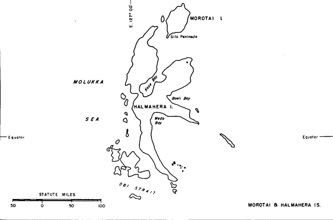
Halmahera
Between bouts of malarial fever in February 1858, on Ternate or perhaps on Halmahera itself, Alfred Russel Wallace wrote down the idea that would change biology forever. Natural selection: the survival of the fittest. He sent his letter to Darwin, and the rest is scientific history. But Wallace had come to these islands for a different reason. He was hunting the standardwing bird-of-paradise, Semioptera wallacii, which he would later call his greatest prize. The bird is endemic to Halmahera, a massive island shaped like a four-armed spider that sprawls across the equatorial sea east of the volcanic cones of Ternate and Tidore.
The Spider in the Sea
Halmahera is the largest island in the Maluku chain and the biggest in all of Indonesia outside the five main islands. Its distinctive shape, four peninsulas radiating from a mountainous core, is the product of tectonic forces that continue to shape the region. The island sits on a volcanic arc uplifted by the northward collision of the Australian continent and the subduction of the Pacific Plate. Active volcanoes punctuate the landscape: Dukono smokes at the northern tip, Mount Ibu rumbles on the northwest coast. Ultramafic rocks and ophiolites, fragments of ancient ocean floor thrust above sea level, form the bedrock of the eastern peninsula. Roughly half the island's population is Muslim and half Christian, a demographic balance that would prove tragically consequential at the turn of the millennium.
Four Kingdoms and a Forgotten Fifth
Halmahera's history has long been shaped by powers based on smaller islands offshore. The Maloko Kie Raha, the four great kingdoms of Maluku, consisted of the sultanates of Ternate, Tidore, Bacan, and Jailolo, the last of which was based on Halmahera itself. A fifth kingdom, the Loloda, dating to the 13th century and also based on northern Halmahera, was never recognized among the prestigious four. When the Dutch East India Company colonized the archipelago, it was these sultanates, not Halmahera's own scattered populations, that served as intermediaries. During World War II, the Japanese established a naval base at Kao Bay. The island's fortunes continued to be dictated by outside forces well into the modern era.
The People of the Forest
Two related but distinct peoples share Halmahera's landscape. The Tobelo, whose name translates roughly as "people who live outside of the forest," inhabit the coastal areas. In the island's deep interior, the semi-nomadic Togutil, the "people who live inside of the forest," number between 1,500 and 3,000 individuals. Within Aketajawe-Lolobata National Park, an estimated 300 to 500 Togutil live in near-complete isolation, sustaining themselves from the forest as their ancestors did. They are among the last uncontacted peoples in Indonesia. Their way of life now faces an existential threat from massive nickel mining operations that are consuming Halmahera's forests to feed the global demand for electric vehicle batteries.
Nickel and the New Colonialism
The Weda Bay Industrial Park in North and Central Halmahera hosts one of the world's largest nickel mining operations. Since Indonesia banned the export of unprocessed nickel ore in 2022, the raw material must be smelted on the island before shipping, requiring an expanding complex of processing plants. Eleven power plants have already been built, with three more under construction. The increased global demand for nickel, driven by the electric vehicle revolution, makes the park likely to grow further. For the Togutil people living in the surrounding forests, this represents a new version of an old pattern: outside powers extracting Halmahera's resources while the island's own inhabitants bear the costs. The colonial-era spice trade has given way to a battery-age mineral rush, but the fundamental dynamic remains.
Between Two Capitals
In 2010, the provincial government of North Maluku made a decision that reshuffled the region's geography of power. The capital moved from Ternate City, the volcanic island that had dominated the region for centuries, to Sofifi, a small settlement on the western coast of Halmahera. The logic was practical: Ternate is so small it can be driven around in forty-five minutes, with no room to expand. Halmahera has land, and Tobelo, the largest town on the island, is growing rapidly since electing its first directly chosen bupati. Yet the shift is symbolically striking. For five hundred years, Halmahera's fate was determined by the tiny islands off its coast. Now, slowly, the balance is tilting toward the giant spider in the sea.
From the Air
Halmahera is centered at approximately 0.70N, 127.84E and is unmistakable from the air: its four spider-like peninsulas make it one of the most distinctive island shapes on Earth. Active volcanic peaks include Dukono (north) and Mount Ibu (northwest). The Weda Bay Industrial Park is visible on the east coast as a cleared area with industrial facilities. Aketajawe-Lolobata National Park covers the mountainous interior. The nearest airports are Sultan Babullah Airport (WAMN) on Ternate to the west and Kuabang Kao Airport (WAMK) on northern Halmahera. Best viewed at 25,000-35,000 feet to appreciate the full spider shape of the island.
Nearby Stories
- Makian 47 km away
- Aketajawe-Lolobata National Park 61 km away
- The Ocean's Hidden Crossroads 95 km away
- USS Shark (SS-174) 97 km away
- Morotai Island 158 km away
- The Sea That Swallows Itself 223 km away
- Japanese Submarine Ro-41 235 km away
- Bitung 248 km away