
Harry's Walls
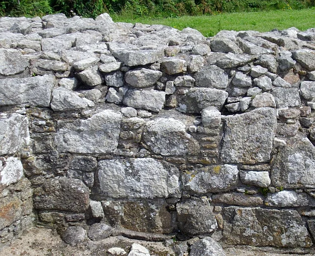
Edward VI was thirteen years old when his government began building Harry's Walls in 1551. He would be dead before it was abandoned. The fort his ministers commissioned to guard the new harbour at Hugh Town was meant to be the most advanced piece of military engineering in England, an Italianate star fort with arrow-headed bastions and curved orillons that no English mason had ever built before. The work stopped in 1554, before the walls reached their full height. Only the south-western corner stands now, two squat bastions and a low curtain of granite, waiting for an army that never came. The name is wrong, too. The locals long credited the fort to Edward's father, the great wall-builder Henry VIII, and called the ruin Harry's Walls. The mistake stuck.
A Boy King's War Scheme
When Henry VIII died in 1547 he left a nine-year-old heir and a council of nervous adults. Edward Seymour, the Duke of Somerset, took the regency. His brother Thomas inspected the Isles of Scilly and reported them under-defended, sitting as they did on the sea road between Europe, Ireland and Scotland. Work began on Tresco first. Somerset fell from power in 1549, was eventually executed, and Captain William Tyrrell was sent down to look again. In May 1551, John Killigrew, then captain of Pendennis Castle in Falmouth, received the order to build a fort on St Mary's. The instructions specified the position with peculiar 16th-century precision: upon the little hill betwixt the freshe water and St. Marie Roode. Lead would be shipped for the roof that summer. A brewhouse and a mill were on their way from South Wales.
The Most Advanced Fort in England
The plans show ambition disproportionate to a small Atlantic harbour. The fort would have been a square enclosure with four arrow-headed bastions at its corners, each protected by orillons, the curved stone shoulders that allowed defenders to shelter inside while firing flanking shots along the curtain walls. This was Italianate design, the cutting edge of Continental military architecture. Henry VIII had introduced it in fragments at Portsmouth's Southsea Castle and at Yarmouth Castle on the Isle of Wight, but nothing on this scale had been attempted in England. The historian Andrew Saunders called the intended design the most advanced piece of military engineering for its date to be seen in this country. By 1554 two sakers, light artillery pieces, sat installed in what walls did exist.
Why the Walls Stopped
Construction halted. The walls never reached their full height; the south-west bastion stands 2.3 metres tall today, the curtain wall 1.7 metres. For centuries the locals blamed the siting. The antiquary William Borlase, who visited in 1752, said the fort had been begun injudiciously, placed too far inside the headlands to command anything that mattered. John Troutbeck, writing at the end of the 18th century, agreed that the position commanded none of the sounds to any effect. More recent research is gentler. The fort may have been designed to work in concert with another planned site; no single position can adequately defend St Mary's complicated coastline anyway. The likelier killer was money. Edward's regents spent an unsustainable 35,228 pounds on fortifications during his short reign. When the French invasion threat faded, so did the will to keep paying.
Forty Years Later, Star Castle
The Isles of Scilly were not left undefended. In 1593, Queen Elizabeth's government built Star Castle on the higher ground of the Garrison, a properly star-shaped structure that still stands and now operates as a hotel. Harry's Walls were left to crumble. In the 17th and 18th centuries the abandoned foundations were used as a tip; rubbish piled inside the unfinished bastions. The site was eventually scheduled as an ancient monument. English Heritage took it on in the 21st century, opened it to visitors free of charge, and stabilised what remains. The granite blocks and rubble of the south-west curtain are well-preserved despite four centuries of weather. From the walls there is a clear view of the harbour that the fort was meant to guard.
What a Ruin Teaches
Harry's Walls is not a story of defeat in battle. It is a story of a state that ran out of money before it could finish what it had started. The Tudor government tried to project power into a remote Atlantic archipelago using techniques borrowed from Italy, and the project collapsed under its own cost. The two surviving bastions are useful precisely because they were never improved or completed; you can see exactly how an Italianate fort was meant to be built, which capstones meant to align with which slabs, where the orillon was supposed to curve. Most English forts of this era were either finished into oblivion by Victorian gunners or absorbed into later defences. Harry's Walls froze in the middle of a sentence. The sentence reads: Edward VI's regents wanted to build the future, and the future did not arrive.
Flight Context
Coordinates: 49.9183°N, 6.3067°W. The walls sit on a low rise on the north side of Hugh Town, about 400 metres inland from St Mary's Pool. From the air at 2,000 feet the granite outline is visible as a pale L-shape on the heath above the harbour. St Mary's Airport (EGHE) is roughly 2 kilometres east. The ruin pairs naturally with a wider view of the Garrison peninsula, where Star Castle, the fort that replaced this one, dominates the western headland.
From the Air
Coordinates: 49.9183°N, 6.3067°W. The walls sit on a low rise on the north side of Hugh Town, about 400 metres inland from St Mary's Pool. From the air at 2,000 feet the granite outline is visible as a pale L-shape on the heath above the harbour. St Mary's Airport (EGHE) is roughly 2 kilometres east. The ruin pairs naturally with a wider view of the Garrison peninsula, where Star Castle, the fort that replaced this one, dominates the western headland.
Nearby Stories
- Penlee Lifeboat Station 5.5 km away
- Black Swan Project 20 km away
- Tater Du Lighthouse 25 km away
- The Brisons 31 km away
- 1979 Fastnet Race 54 km away
- SM U-27 110 km away
- HMS Affray 149 km away
- Tower of Hercules 700 km away