.JPG)
Helmond
Brandevoort should not work. Drop a brand-new neighbourhood into the meadows on the edge of an industrial Dutch city, design the streets to look like a Brabantine market town from three hundred years ago, give the buildings white shutters and brick gables and tight little squares, and any sensible planner will tell you that the result will feel like a theme park. Brandevoort feels like a town. Cyclists ride home from work along streets that meander as if they had grown there. Children play in courtyards that look like they belong in a painting. The eighteen thousand people who live in this district of Helmond got their version of an old Dutch place precisely because it never existed, and the project, built between 1993 and 2017, has become one of the most studied New Urbanism experiments in Europe.
The Helmet on the Shield
The name is older than anyone really knows. Helmond's coat of arms first appears in 1241, a helmet against a shield, the kind of visual pun that medieval heralds loved - helm meaning helmet in Dutch. The actual etymology is probably less elegant: hel from a Proto-Germanic word for low-lying ground, mond for higher ground or a secure place. A settlement of streams that gradually silted into solid land, then rose into a small dry place between them. By the year 1000 a village had grown west of the present city centre, and a wooden hall called 't Oude Huys - 'the old house' - stood at what would later become Helmond Castle. The first documented Lord of Helmond, Hazelo, turns up in records from 1108.
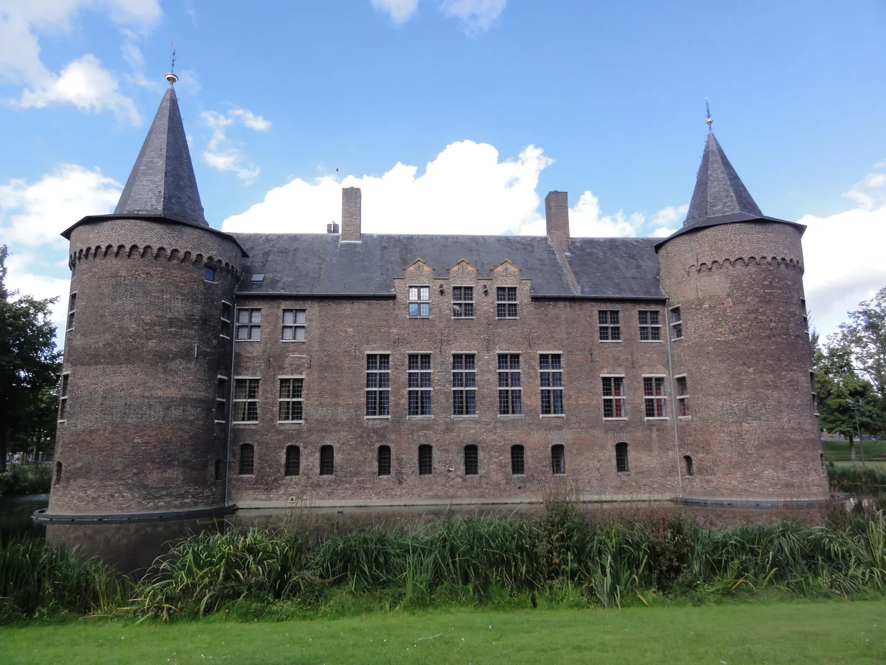
Maria's Town and a Stone Keep
In 1225, Henry I of Brabant founded the town in something like its modern form, and Helmond received its town privileges in 1232. When Henry died, the territory passed to his daughter Maria of Brabant, the Holy Roman Empress, who spent considerable time at 't Oude Huys and founded the nearby Binderen Abbey, an act that anchored Helmond's medieval growth. In 1325, Jan II Berthout van Berlaer began the stone keep that became Helmond Castle, the moated square fortress of squat round towers that still dominates the old city centre. By 1400 the town had its full ring of ramparts. By 1389, seven guilds were authorized to operate, and Helmond's weavers were selling wool and linen across Brabant. Then came the wars - the instability of the Duchy of Guelders, Maarten van Rossum's brutal sack in 1543 - and the city's first big arc of medieval prosperity ended in fire.
Weavers, Plague, and the Long Recovery
Helmond's loyalty to Philip II of Spain put it on the wrong side of the Eighty Years' War. Dutch Republic armies captured and lost the city twice; only the castle held out. The plague of 1636 finished what the war had started, and most of the surviving weavers fled north to Haarlem. The peace of 1648 let Helmond rebuild, and the weavers it had lost became its salvation - they formed a partnership with the Haarlem merchants and resumed sending textiles into the new Dutch economy. Catholics, suppressed during the Republic, came back into city government only after the French Republic invaded in 1793 and Patriot reformers swept aside the old constitution. By 1798 the institutional framework of the Dutch Republic was gone. Universal male suffrage arrived here three years earlier than in much of the country.
The Canal, the Cocoa, and the EDAH
Steam changed everything. The 1826 opening of the Zuid-Willemsvaart canal cut a navigable line through the city and brought coal, raw cotton, and finished goods within easy barge reach of the Antwerp and Rhine trades. The 1866 railway station accelerated growth again. By 1900, Helmond had branched out from weaving and dyeing into cotton printing, into metalworking - machines, wires, hardware - and into a curiously domestic industrial menu of a cocoa factory, a margarine factory, and the EDAH grocery chain that grew into a national name. The Vlisco textile mill on the canal bank, founded in 1846 and still in operation, became famous for the bold wax-printed fabrics it exports across West Africa, where Vlisco patterns are a cornerstone of everyday and ceremonial dress.
Occupation, Liberation, and the Future Town
In May 1940 the Wehrmacht took Helmond, and its city administration was handed to NSB collaborators - the Dutch fascist movement that ran much of the country's wartime civil bureaucracy on Berlin's behalf. The British Army liberated the city on 24 and 25 September 1944, in the broader push that followed Operation Market Garden. Post-war Helmond rebuilt fast: industry returned, the Cube Houses arrived as one of the country's earliest commitments to architectural surrealism, and by 1999 the city had passed eighty thousand residents. Then came Brandevoort - the conscious decision, made in the early 1990s, to grow not as another grid of cul-de-sacs but as a planned old town. It is the kind of thing Dutch planners do well: take a heritage they did not quite have, build it carefully, and live in it as if it had always been there. From the air, you can see exactly where modern Helmond ends and Brandevoort begins. From the ground, increasingly, you cannot.
From the Air
Helmond lies at 51.48°N, 5.66°E in southeastern North Brabant, about 14 km east-northeast of Eindhoven. From the air, the city is identifiable by the Zuid-Willemsvaart canal cutting through its centre, by the dark moated square of Helmond Castle in the old town, and by the very distinctive crescent-and-grid plan of the Brandevoort district on the southwestern edge - a deliberately old-looking new town with a roughly circular outer ring of houses around a tighter historic-style core. Nearest major airport: Eindhoven (EHEH), about 17 km west-southwest.
Nearby Stories
- Aldendriel Castle 1.2 km away
- Rheindahlen 2.4 km away
- Ted Swales 4.5 km away
- Maaseik 5.7 km away
- Fort Crevecoeur 6.2 km away
- Haldern Pop 15 km away
- Bismarck Tower (Viersen) 17 km away
- City Hall of Tilburg 20 km away