.jpg)
Fort Crevecoeur
The name translates to heartbreak. Crève-coeur. The Dutch did not love their fort sentimentally, and the citizens of nearby 's-Hertogenbosch certainly did not love it at all - which may be precisely the point. Built in 1587 on the spot where a Dutch officer had just been killed and his Spanish opponent mortally wounded, Fort Crevecoeur sat at the mouth of the small Dieze river like a tollbooth manned by enemies. For more than three centuries it would do what no army alone could do: it bent water against a city.
Born From a Battle
The Eighty Years' War was barely a generation old in the summer of 1587 when Philip of Hohenlohe, leading the Dutch States' army, met Claude de Berlaymont near the village of Engelen. Berlaymont's Spanish-Catholic force was larger - 42 companies of foot, 25 squadrons of cavalry - but it was Berlaymont who took the wound, carried back to 's-Hertogenbosch where he died on 14 July. On that same battlefield Hohenlohe began building. The new fortification sat astride the Dieze where it joins the Meuse, a position the Dutch chose for one simple reason: their navy could supply a fort by water faster than any Spanish army could reach it by land. Once the walls went up the river belonged to whoever held them.
Drowning a City Without Drawing a Sword
Crevecoeur changed hands repeatedly in those first decades, but the trick the Dutch perfected there had nothing to do with cannon. On 29 June 1593 a Spanish army under Count Mansfeld approached. The Dutch garrison threw a dam across the Dieze, the river backed up over the fields, and the surrounding country turned to a shallow sea. Mansfeld broke off the siege and went home. The same weapon worked again and again. By controlling the locks at Crevecoeur the Republic could flood the polders around 's-Hertogenbosch on demand, making the great Catholic city, in the words of one observer, resemble an island. The fort never had a civilian population - just soldiers, lock-keepers, and a small church - and it never needed one. Its purpose was the water gate.
Why the Heartbreak Name
Nobody is certain why someone wrote Crève-coeur on a map in the early 1600s. The romantic explanation was that the fort caused heartbreak to the citizens of 's-Hertogenbosch, cut off from the Meuse upstream. A more pragmatic guess: the constant flooding broke the heart of the farmland. A third theory points to taxes - the Dutch eventually levied duties one-third higher on goods bound for the Spanish-held city, a chokehold that lasted until 1625. The name itself was not unique. Other fortresses across Europe bore variations of it, suggesting that besieging engineers everywhere shared a grim sense of humor about places designed to ruin somebody's day.
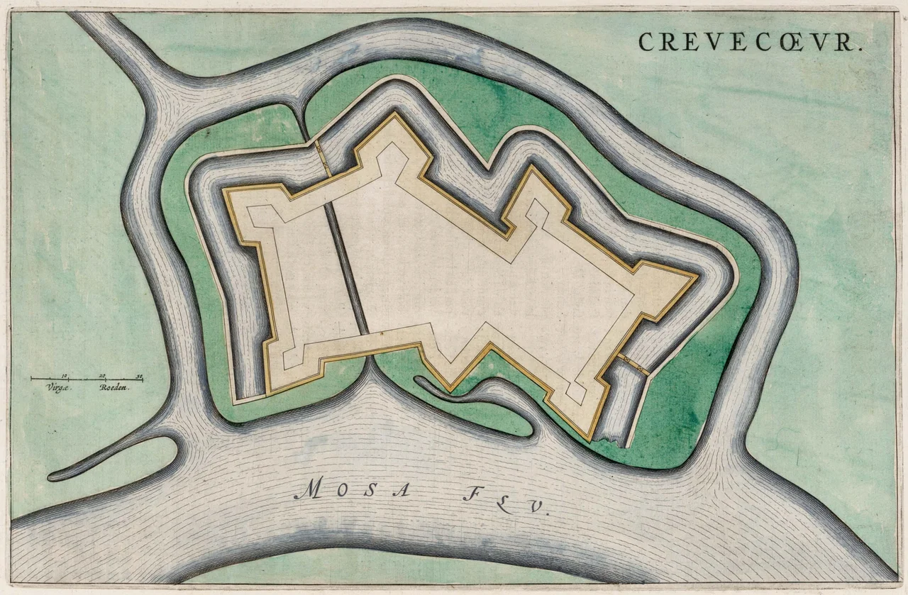
The Coehoorn Rebuild
The French wrecked the original fort in 1673, blowing up the powder magazine with 500 pounds of gunpowder packed into its foundations, and the Dutch decided the ruin was not worth fixing. By 1701 they had changed their minds. The great military engineer Menno van Coehoorn drew up a seven-bastion design, and by 1735 a smaller version of it stood at the river mouth. The bastions had names that read like a regional roll call - Empel, Heel, Maase, Boeckhoven, Henriette, Engelen, Dies. Locks built inside the fort allowed peacetime shipping to pass straight through; in wartime the gates closed and the Dieze flooded the city again. During the War of the Austrian Succession the system worked beautifully. Then in 1794 a French army arrived, and the fort's commander, Colonel Tiboel, surrendered after a brief siege. He was court-martialed and acquitted: there had been no oven for bread, no cartridges for the muskets, and the soldiers slept in the open air.
What the River Still Carries
The army decommissioned Crevecoeur in 1926. Eleven years later, road builders sliced off the two eastern bastions to lay the new highway from Hedel into 's-Hertogenbosch. In December 1944 Canadian troops captured what remained from German occupiers who had used it as a flak battery. The Dutch Corps of Engineers took the grounds after the war and during the Cold War kept pontoon-bridge equipment there in case the Hedel Bridge was destroyed by an enemy nobody named aloud. Today the canal through the fort is filled in. A modest weir built where the Dieze splits controls most of the water level in eastern North Brabant - still, after everything, a place where moving water decides what happens on the land. A fish ladder built in 2012 winds south of the weir, returning to the river something it had been denied for centuries: a way through.
From the Air
Fort Crevecoeur sits at 51.73 N, 5.26 E, where the Dieze river joins the Meuse a few kilometers north of 's-Hertogenbosch. Cruise at 2,500 feet for the clearest view of the star-shaped earthworks - bastion outlines remain visible against the surrounding farmland. The A2 motorway runs east of the site; Eindhoven Airport (EHEH) lies 30 nm south. The flat polder landscape around the fort, often partially flooded in winter, gives a vivid sense of why water was the region's master weapon.
Nearby Stories
- Helmond 3.4 km away
- Ravenstein 3.7 km away
- Utrecht tram shooting 5.5 km away
- Zoetermeer 6.2 km away
- Essen, Belgium 8 km away
- Barendrecht 9.5 km away
- Baarle-Nassau 13 km away
- Hoge Veluwe National Park 13 km away