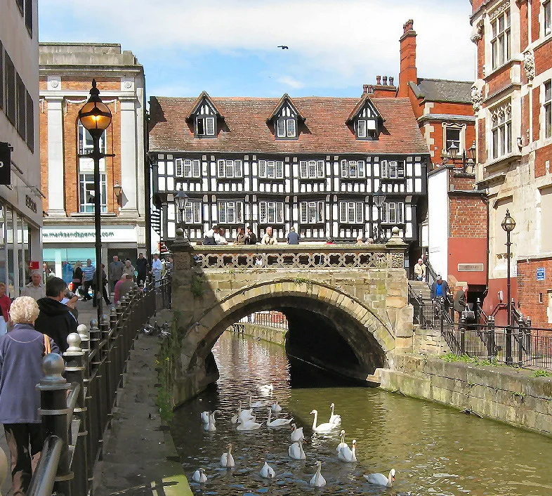

High Bridge, Lincoln
Once upon a time medieval bridges all over Europe carried buildings - the bridges were valuable real estate, after all, with constant foot traffic and limited supply of frontage - and Old London Bridge was the most famous example, lined with houses and shops, even a chapel in the middle, that stayed in place for six hundred years before the whole structure was finally demolished in the 1830s. Almost all the others went the same way: knocked down to widen the river for shipping, or to ease the flow during floods, or because the buildings on top finally became too dangerous to maintain. High Bridge in Lincoln is the only one in the United Kingdom that survived. The bridge itself dates to around 1160. The half-timbered shops perched on top of it date to about 1550. They are, together, the only intact medieval bridge-with-buildings still functioning in Britain - and a tea shop has been operating in the one on the corner since 1937.
The Glory Hole
Boaters call it the Glory Hole, a name that probably has nothing to do with what you might be thinking. The phrase has been used by Witham bargemen for centuries to describe the narrow, dark, slightly menacing arch through which they had to thread their boats. After heavy rain the bridge becomes effectively unnavigable - the water rises, the arch shrinks, and the gap between hull and stone narrows toward zero - and in 2023 a holiday boat got firmly stuck under it and had to be rescued by the fire service in a minor news story that made the national papers. The arch is a single span about 22 feet wide. Its narrowness limits the size of every boat that can cross from Brayford Pool, at the head of the Foss Dyke Roman canal, down the Witham to Boston and out to the sea. That limit has shaped Witham navigation for nearly nine centuries. Lincoln Castle controls the limestone ridge above; High Bridge controls the river below.
Built in 1160, More or Less
The bridge was constructed around 1160, in the reign of Henry II, on a site where some kind of bridge probably already existed. The ribs of the original 12th-century structure still survive inside the present masonry - five barrel-vaulted ribs running across the span - making High Bridge possibly the second-oldest masonry arch bridge in Britain (after the Norman bridge at Bow in London) and certainly the oldest that still carries buildings. The original bridge was 33 feet long at the centre and supported only its own road surface. Around 1235, builders extended the bridge downstream to accommodate a small bridge chapel - dedicated to Thomas Becket, the most fashionable English saint of the period - with quadripartite vaulting underneath the new section. Bridge chapels were a particular medieval institution: a small church on the span itself where travellers could pray for safe passage, leave alms, and where in return the priest would maintain the bridge. The arrangement worked well for three centuries.
Shops Instead of a Chapel
The Reformation ended the bridge chapel in 1549 - the same wave of dissolution that broke up the Greyfriars and Whitefriars in Lincoln. With no priest to maintain the bridge, the corporation took it over directly. In the 1540s, the upstream side of the bridge was extended with a flatter arch specifically designed to support timber-framed buildings, and around 1550 the present row of jettied shops was built on that platform. Two upper storeys overhang the lower storey on timber brackets, and at the corners are carved figures of angels - one of those small medieval architectural jokes that took particular pleasure in putting holy figures in unholy places. The original bridge chapel was demolished outright in 1762 and replaced with a stone obelisk that served as a public conduit, supplying water to the surrounding streets. The obelisk was itself removed in 1939 when it became an obstruction to traffic crossing the bridge. The medieval shops survived all of this. They were partly dismantled and re-erected around 1901-02 by the Lincoln architect William Watkins to stabilise the timber frame, but the building visitors see today is essentially the same one Elizabethan merchants stocked and traded from.
Stokes Coffee
The shop on the corner has been Stokes Tea & Coffee since 1937, and the same family-owned company has been there ever since. R. W. Stokes & Sons started roasting coffee in Lincoln in 1902 and took over the High Bridge corner shop thirty-five years later. The coffee shop occupies the medieval ground floor - low ceilings, exposed timbers, the river-arch visible through windows on the river side - and the smell of roasting beans drifts down the High Street whenever the door opens. The fact that the building is constantly inhabited and properly maintained is the single biggest reason it has survived. Empty medieval buildings rot quickly. Lived-in ones, even ones perched on a 12th-century bridge over a periodically flooding river, can last almost indefinitely if the people inside them care enough to fix the small things before they become big ones. Stokes have been caring enough for eighty-nine years.
Walking the Bridge
The High Street through Lincoln was pedestrianised in 1971, after a bypass took the modern traffic away from the city centre. The pedestrianisation gave the bridge back to walkers, and you can now stand on it and look down through the Glory Hole arch at the slow brown Witham flowing eastward toward Boston and the Wash. The William Jessop scheme of the 19th century - which would have rerouted the Witham south of the city centre, presumably with the demolition of High Bridge in mind - was never built. Most of the comparable buildings-on-bridges in Europe were demolished or remodelled out of existence: the Krämerbrücke in Erfurt and the Pont des Marchands at Narbonne are among the few survivors. England has only High Bridge. Stand on it on a wet November afternoon and you can hear the Witham slapping the stonework and see your breath in the air through the timbered windows of the shops above. The river has been running under this arch since the second year of Henry II's reign. It will probably still be running under it long after the rest of us are gone.
From the Air
High Bridge spans the River Witham at 53.2285°N, 0.5407°W in central Lincoln, just south of the Stonebow on the pedestrianised High Street. From the air the bridge appears as a narrow stone arch with a row of half-timbered buildings on its west side, immediately upstream of the wider water of Brayford Pool. The site is in the lower town, below the limestone ridge that carries Lincoln Cathedral and Castle, about a quarter-mile south of those landmarks. Recommended viewing altitude is 1,500 to 2,500 feet AGL. The Witham's slow east-flowing line through the city is unmistakable and helps anchor any visual approach. Nearby airfields include RAF Waddington (EGXW) about five nautical miles south, RAF Scampton (EGXP) seven nautical miles north-northwest, and Humberside Airport (EGNJ) twenty-six nautical miles north-northeast. The Foss Dyke Roman canal joins the Witham at Brayford Pool just southwest of the bridge and runs west toward the Trent, providing another clear navigation line in clear weather.
Nearby Stories
- Louth Navigation 2.9 km away
- Major Oak 3.6 km away
- Grantham Rail Accident 8 km away
- South Yorkshire Aircraft Museum 9.3 km away
- Gotham, Nottinghamshire 11 km away
- Alford Windmill 16 km away
- RAF Binbrook 21 km away
- Wisbech 29 km away