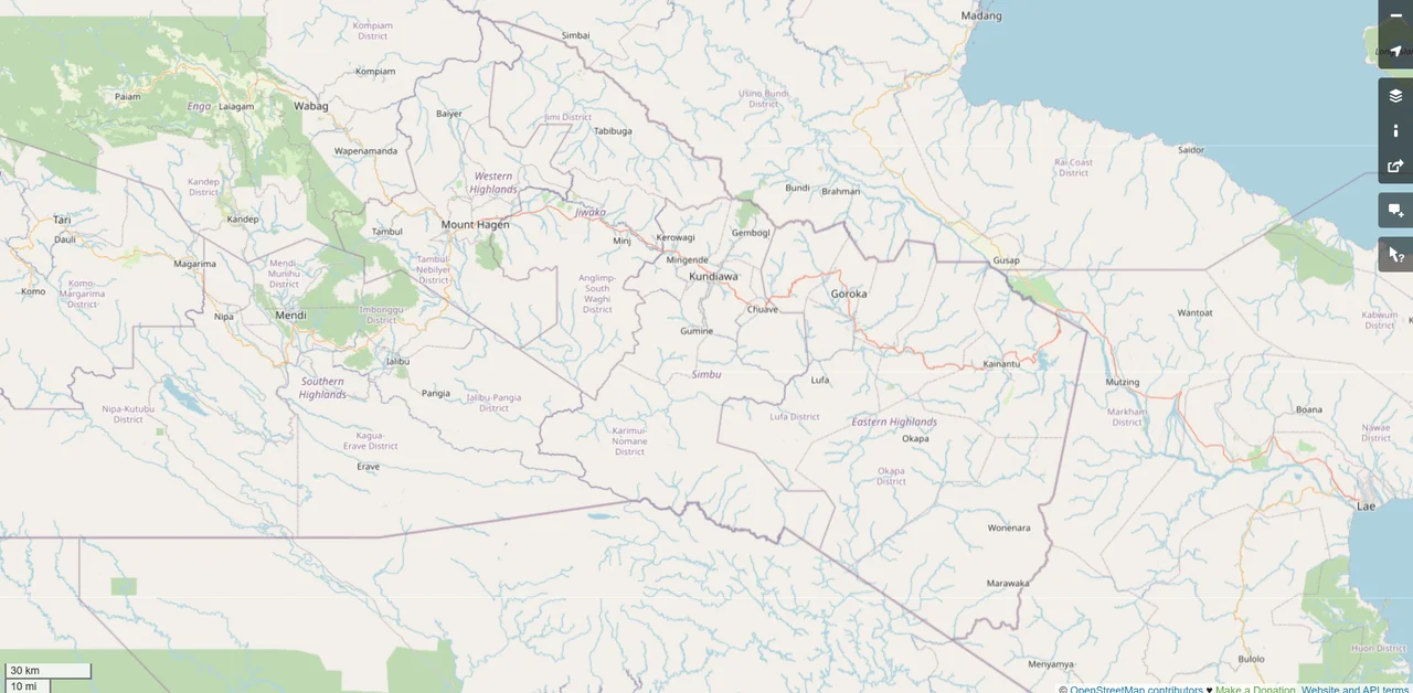
Highlands Highway
There is really only one road in Papua New Guinea that matters, and it climbs. The Highlands Highway - sometimes called the Okuk Highway after a former deputy prime minister - begins at the port of Lae on the Huon Gulf and winds inland for hundreds of kilometres through some of the most densely populated highland country in the world. It is a two-lane road for nearly all its length, often hindered by potholes, landslides, and armed robberies committed by bandits the country knows as raskols. It is also the sole overland lifeline feeding fuel, rice, cement, and mining equipment to more than a million people living above 1,500 metres. When it closes, the Highlands close with it.
From the Huon Gulf to the Watershed
From Lae the road heads west up the Markham Valley through Morobe Province - a broad, dry, grassy corridor that is the easiest stretch of the entire highway. At the Markham Valley turn-off, a branch continues north as the Ramu Highway through the Ramu Valley into Madang Province, ending at the coastal town of Madang. The main highway turns left, though, and climbs over the Kassam Pass at roughly 1,500 metres into Eastern Highlands Province. It crosses the wall of the Yonki Dam, runs through Kainantu and Henganofi, and arrives at Goroka. Past Goroka the grade steepens again, the switchbacks tighten, and the road climbs to its highest point: the Daulo Pass at 2,478 metres, where the cold comes off the ridges even on hot days.
Over the Daulo and Into the West
Over the Daulo the highway drops into Simbu Province and its capital, Kundiawa, then continues through the Wahgi Valley - the heart of highlands agriculture, where sweet potato gardens climb every slope - into Western Highlands Province. At Mount Hagen, the largest city in the highlands, it picks up more traffic than any stretch behind it. Just past Hagen, at a village called Togoba, the road forks. A southern branch runs to Mendi, the capital of Southern Highlands Province, then on to Tari in Hela. The other branch climbs north and west into Enga Province, reaching Wabag and ending at Porgera, the gold-mining town where the pavement runs out. The Porgera mine, one of the largest in the Pacific, has for decades been both the highway's biggest single user and its most reliable maintainer.
Bridges, Aid, and Roadblocks
Keeping the highway open is a running negotiation between weather, geology, and money. In 2006 the Australian government's AusAid programme resurfaced the eastern section from Lae to Goroka. Japanese and Taiwanese projects have rebuilt key bridges. The Porgera Joint Venture spends heavily on its own stretch, particularly from Mount Hagen to the mine, upgrading cuttings, bridges, and culverts to handle the consumables and equipment moving up from Lae port. None of this makes the road safe in the way a driver in Europe or North America would recognise. Armed hold-ups remain common enough that convoys sometimes run with police escorts. Breakdowns can become vulnerabilities. The road is a public utility that also carries private risk.
When the Mountain Wins
Landslides and washouts are not rare events on the Highlands Highway; they are a routine feature of it. In April 2008, three separate points along the Simbu Province section became impassable at different times. The worst of those failures destroyed a 150-metre stretch of roadway at Gera village, ten kilometres east of Kundiawa, on 11 April - cutting off the upper Highlands provinces from all road transport for days. Fuel ran short. Stores emptied. Then, on 24 May 2024, the Enga landslide at Kaokalam buried six villages and also washed out a section of the highway in Enga Province. More than 670 people died in that slide. The road itself could be rebuilt. The villages could not.
A Country That Depends on Two Lanes
Most roads in Papua New Guinea are local, short, and seasonal. There is no rail network of consequence. The Highlands Highway is the one continuous overland thread binding the country's second-largest port to its most populous highland provinces, and nearly everything that moves between them moves along it. That single ribbon of asphalt and gravel crosses three mountain passes, threads half a dozen river valleys, and carries the weight of national economies. When it is good - on a clear morning in the Markham Valley, with the Finisterre Range rising to the north - it is one of the great drives in the Pacific. When it is bad, it is a reminder that in Papua New Guinea geography still writes most of the rules.
From the Air
The Highlands Highway's highest point, the Daulo Pass at 2,478 metres, sits at roughly 5.55 degrees south, 143.80 degrees east between Goroka and Kundiawa. From altitude the highway traces a visible line across the highlands - Lae (AYNZ / LAE) on the coast to Goroka (AYGA / GKA), Mount Hagen (AYMH / HGU), Wapenamanda (AYWD / WBM) in Enga, and ending at Porgera. The Kassam Pass (about 1,500 metres), Daulo Pass (2,478 metres), and the steep climb past Porgera all produce visible ridgelines and road cuts. Expect rapidly changing mountain weather, heavy afternoon buildups, and raw landslide scars on slopes above and below the roadbed, including the large 2024 Enga landslide scar near 5.37 degrees south, 143.39 degrees east.
Nearby Stories
- 2024 Enga Landslide 19 km away
- Mount Hagen 29 km away
- Southern Highlands Province 42 km away
- Territory of New Guinea 64 km away
- Mount Wilhelm 67 km away
- Goroka 103 km away
- 2024 East Sepik Earthquake 130 km away
- Sepik 171 km away