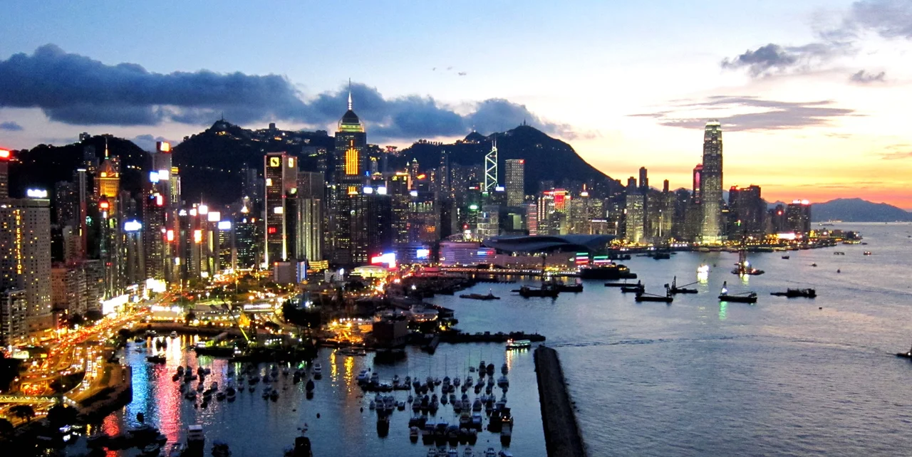

Hong Kong Island
When British forces arrived in January 1841 and raised the flag on what they called Possession Point, they found an island of perhaps 3,000 people scattered across a dozen fishing villages. The territory had human settlement going back 6,000 years — Neolithic artefacts have been found at Stanley — and had been changing hands among Chinese dynasties since the Qin absorbed the region in 214 BC. None of that history seemed to matter much to the colonial administration that followed, which set about building a city from the northern shore with considerable energy and very little local consultation. The island the British named Hong Kong — from the Cantonese *Heung Gong*, meaning 'fragrant harbour' — had been known simply as Hong Kong before it became a colony. The name now refers to everything else.
Six Thousand Years Before the Harbour
The standard story of Hong Kong begins in 1842, with the Treaty of Nanking and the formal cession of the island to Britain following the First Opium War. But the island had been inhabited and commercially active long before any empire arrived with treaties. Song dynasty copper coins — the universal currency of transregional trade in their era — were unearthed where the Royal Hong Kong Yacht Club now stands, on what was Kellett Island before land reclamation connected it to the Causeway Bay shore in 1969. The implication is clear: this was a place of commerce and connection centuries before Victoria Harbour acquired its name. The Ming dynasty clearance order of 1661, which forced coastal residents inland to prevent them supplying Ming loyalists in Formosa, temporarily emptied the area. Piracy filled the gap. By the time the British arrived, the island's population was again concentrated, mostly fishing, mostly poor.
The City the British Built
Victoria — named for the queen, as colonial cities invariably were — grew fast along the northern shore, where deep water allowed large trade ships to anchor directly offshore. Government House rose on the slope above Central. The legislative, judicial, and financial institutions of the colony stacked up in the Central district, which remains the political and commercial core of Hong Kong to this day. What the British built was a functioning entrepôt — a trade port that made money by standing between Chinese goods and global markets. The city's success depended on the harbour and on the willingness of Chinese merchants to work within British legal frameworks. By the early 20th century, Hong Kong Island was the established heart of a prosperous colonial territory, its skyline already unmistakable from the water.
Black Christmas
On 8 December 1941, eight hours after the attack on Pearl Harbor, Japanese forces began their assault on Hong Kong. British, Canadian, and Indian troops — with the Hong Kong Volunteer Defence Corps — fought alongside each other for 18 days. The defence of the Wong Nai Chung Gap, a strategically critical pass across the island's mountainous spine, was particularly brutal. Canadian Winnipeg Grenadiers held the gap under sustained attack; Japanese casualties there were approximately 600. But the defenders were ultimately overwhelmed. On 25 December 1941, Governor Mark Young surrendered in person at the Peninsula Hotel across the harbour. Hong Kong's residents still call that day 'Black Christmas.' The occupation that followed lasted until 1945 and brought hyperinflation, food rationing, forced repatriation, and a population drop from 1.6 million to 600,000.
A City Layered Over Itself
After 1945, Hong Kong Island grew in ways the colonial planners could not have anticipated. The Communist revolution on the mainland sent waves of refugees southward; the population expanded rapidly. Quarry Bay, North Point, Shau Kei Wan, Aberdeen — districts that had been industrial or undeveloped — urbanised quickly. When Hong Kong's manufacturing economy gave way to finance and services, former industrial districts like Wan Chai and Causeway Bay became new commercial centres, their cheaper rents attracting businesses that couldn't afford Central. The result is a city of legible strata: the colonial formality of the Central waterfront, the dense residential towers of the Mid-Levels, the older neighbourhood fabric still visible in Sheung Wan and parts of Wan Chai, the beaches and country parks of the southern coast. The island is 78.59 square kilometres, of which 6.98 were reclaimed from the sea.
Scale, Movement, Altitude
The Central-Mid Levels Escalator — the longest outdoor covered escalator system in the world, opened in 1993 — runs 800 metres horizontally and 135 metres vertically, connecting Queen's Road Central to Conduit Road through a corridor of restaurants and shops. The Peak Tram, a funicular dating to 1888, hauls visitors and residents up to Victoria Peak, where the views across the harbour to Kowloon are among the most photographed in Asia. The island's MTR connections cross the harbour through underwater tunnels to Kowloon and the New Territories; its tram network runs east to west along the northern shore in a straight line from Kennedy Town to Shau Kei Wan. On 1 July 1997, sovereignty transferred to the People's Republic of China, ending 156 years of British rule. The island kept its name, its legal system, its skyline, and its habit of looking outward across the harbour at everything arriving from elsewhere.
From the Air
Hong Kong Island sits at approximately 22.25°N, 114.15°E, forming the southern shore of Victoria Harbour. The island spans roughly 11 km east to west and 8 km north to south. From cruising altitude, it is immediately identifiable by the dense cluster of skyscrapers along its northern shore and the sharp green ridgeline of the mountains running east to west through the interior — Victoria Peak (552 m) is the highest point, prominent on the western end. Hong Kong International Airport (VHHH) lies approximately 35 km to the west on Lantau Island. On approach from the east at 3,000–6,000 feet, the island's southern beaches (Repulse Bay, Stanley, Shek O) contrast strikingly with the urban density of the north shore. The airport's ICAO code is VHHH; Shek Kong Airfield (VHSK) lies to the northwest in the New Territories.
Nearby Stories
- Lok Ma Chau Loop 2.3 km away
- Portas do Cerco 2.3 km away
- Kweilin Incident 17 km away
- Wanshan Archipelago Campaign 34 km away
- Nanxiong Formation 115 km away
- Battle of Nanpeng Island 148 km away
- Heyuan 169 km away
- Cape Maobitou 632 km away