
Humaitá
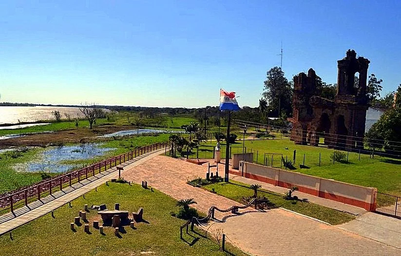
The roofless church says everything. Its brick walls still rise above the riverbank at Humaitá, the windows open to the sky, the nave long since gutted by cannon fire. San Carlos Borromeo was inaugurated on January 1, 1861, and contemporaries called it one of the most beautiful churches in the Americas. Seven years later it was a ruin. Today the people of this small town on the Paraguay River fish its waters and raise their cattle in the shadow of those broken walls - the last great relic of a stronghold that once held an entire war in check.
The Gibraltar of South America
Geography made Humaitá formidable. Here the Paraguay River doubles back on itself in a tight horseshoe bend, and on the low cliff above it the Paraguayans built a sequence of gun batteries that could pour converging fire onto any ship trying to pass. A great chain boom could be raised across the channel to halt enemy vessels and trap them beneath the guns. The fortress controlled river access to the capital, Asunción, 275 kilometers upstream, which made it the cork in the bottle of the entire country. Foreign observers gave it a nickname that stuck: the Gibraltar of South America. Begun under President Carlos Antonio López, it became the linchpin of Paraguay's defense.
A War of Annihilation
The Paraguayan War of 1864 to 1870 set landlocked Paraguay against the combined might of Brazil, Argentina, and Uruguay - the Triple Alliance. It became the deadliest conflict in the history of South America, and for Paraguay it was nearly the end. Scholarly estimates are staggering: a prewar population of roughly half a million was reduced to around 221,000 by 1871, with the loss of well over half the people. Among the survivors, women vastly outnumbered men, so many of the country's males had died in combat, of disease, of hunger, and of exposure. This was not a war Paraguay could win; it was a war it barely survived as a nation.
Two Years That Held a War
Humaitá frustrated the allied advance for more than two years, and the fighting around it produced some of the war's most terrible days. At Curupayty, just downriver, dug-in Paraguayan defenders shattered an allied assault in September 1866, inflicting thousands of casualties at almost no cost to themselves - a victory so lopsided it stalled the invasion for nearly a year. But the alliance had numbers and time, and slowly the fortress was encircled. When Humaitá finally fell in 1868, it was not stormed so much as strangled, its starving garrison forced out. Up to 24,000 troops had once sheltered behind these works; in the end, the town was left wrecked by the very war it had been built to stop.
What the River Kept
Humaitá's name comes from the Guaraní words yma and itá - "ancient stone" - and the description fits a place that now lives mostly in memory. Portions of the old earthworks still scar the ground, and the gutted church draws students from across Paraguay and visitors from far beyond, come to stand among the vestiges of the war. The Cuartel de López, a museum in the former barracks of the Paraguayan commander Francisco Solano López, keeps the small relics of the fighting: bullets, cannon, stirrups, spurs, swords. The rest of the town has returned to a gentler rhythm. Fishermen pull surubí and dorado from the river, and life goes on quietly above the bones of the Gibraltar that once was.
From the Air
Humaitá lies at approximately 27.07 degrees south, 58.50 degrees west, on the left (western) bank of the Paraguay River in the Ñeembucú Department of southern Paraguay. From the air, the defining feature is the river itself - and specifically the tight horseshoe bend that made the fortress so deadly, still clearly visible from altitude. The flat, low-lying floodplain around it turns to marsh and standing water after heavy rain. There is no significant airport at Humaitá; the nearest town with services is Pilar to the south, while the region's main air gateway is Asunción's Silvio Pettirossi International Airport (ICAO: SGAS), about 275 kilometers upriver. Across the border, Argentina's Formosa International (ICAO: SARF) lies to the southwest. Best viewing is from a few thousand feet in the dry winter season, when the river's serpentine path stands out sharply against the green and gold of the surrounding land.
Nearby Stories
- Battle of Estero Bellaco 26 km away
- Corrientes 38 km away
- Chaco National Park 62 km away
- Ypoá National Park 107 km away
- Ibera National Park 120 km away
- Concepcion de Buena Esperanza 141 km away
- Pilcomayo River 175 km away
- Campo del Cielo 264 km away