-P1000532.JPG)
Huoyan Mountain
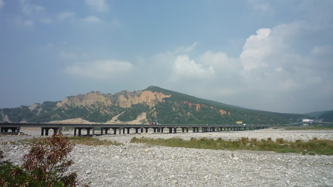
The name does not require translation. Huoyan — Fire Mountain — announces itself the moment the landscape comes into view. Where the surrounding hills are forested and green, this one burns red. Bare laterite cliffs catch the light and throw it back in shades of rust, ochre, and deep crimson. No fire, no volcanic activity — just geology doing something extraordinary with iron-rich soil, tectonic uplift, and the relentless erosive force of Taiwan's typhoon rains. Huoyan Mountain looks like a wound in the earth, and it has been looking that way since the Pleistocene.
What Makes the Mountain Burn
Huoyan Mountain sits at the border of Sanyi and Yuanli townships in southern Miaoli County, rising on the north bank of the Da'an River. Geologically, it belongs to the Toukeshan Formation, a Pleistocene-era geological unit laid down between roughly 2.6 million and 11,700 years ago. What makes Huoyan distinctive is the combination of forces acting on it: tectonic uplift has pushed iron-rich laterite soils toward the surface, while the underlying rock has poor shear strength — it fails easily under stress. Add Taiwan's heavy monsoon and typhoon rainfall, and the result is a mountain that erodes dramatically and continuously. Vegetation cannot establish itself fast enough on the steep, unstable slopes. The red rock stays exposed, baking in the sun, giving the mountain its fire-colored appearance year-round. The summit reaches approximately 602 meters.
Badlands Between Two Counties
Huoyan stands at a geographic and administrative boundary. To the north, Miaoli County; to the south, Taichung. The mountain marks the edge of the Sanyi area and anchors the northeastern boundary visible to travelers on the old and new mountain railway lines that thread this terrain. From the train window, the red cliffs emerge suddenly as a visual shock — a bare, jagged ridge above the tree line, with gullied ravines carved into its flanks. The effect is especially dramatic in afternoon light, when the western-facing slopes glow against the darker greens of the surrounding forest. County Highway 140, which links the coastal lowlands with the mountainous interior of Miaoli, passes along the mountain's south side. The highway was historically vulnerable to landslides triggered by typhoon rains; in 2006, a tunnel was constructed to protect the road from repeated blockages — infrastructure bending around the mountain's instability rather than trying to stabilize the mountain itself.
Protected and Promoted
Taiwan's Forestry and Nature Conservation Agency has placed Huoyan Mountain under protection, recognizing the landscape as both ecologically unusual and visually irreplaceable. The bare laterite slopes support a specific ecology adapted to hot, dry, nutrient-poor conditions — hardy shrubs, grasses, and pioneer species that most mountains in Taiwan's humid climate never develop. Conservation here means accepting the erosion rather than fighting it, preserving the dramatic bareness as part of what the mountain is. At the same time, Huoyan has been embraced as a recreational destination. It appears on Taiwan's list of the 'hundred little mountains' (臺灣小百岳), a Sports Administration initiative promoting accessible, rewarding hikes at shorter summits. The designation has made Huoyan a standard entry on Taiwanese hikers' checklists.
On Foot to the Summit
Two hiking trails climb to the triangulation point at the main summit. The routes are not long — Huoyan is a little mountain, promoted as such — but they are steep, and the exposed laterite underfoot can be slippery when wet. Trekking poles earn their keep here. The trail experience combines dense subtropical forest on the lower slopes with the sudden openness of the bare upper ridges, where the red soil stretches away and the views extend across the Da'an River valley toward the coast. The north peak of Huoyan stands slightly higher than the main summit but is not accessible by the maintained trails. It remains as the mountain reserves something for itself — visible, but not reachable by the usual routes. The Huoyan Mountain Ecology Museum near the base offers context for what visitors see on the slopes: the geology, the ecology, the slow drama of a mountain that refuses to stand still.
From the Air
Huoyan Mountain is located at approximately 24.370°N, 120.724°E, on the Miaoli-Taichung border. From the air at 4,000 feet, the mountain's signature bare red laterite cliffs are unmistakable against the surrounding green terrain — a natural landmark visible for many kilometers in clear weather. The Da'an River shows as a braided channel to the south. Nearest major airport: RCMQ (Taichung International), approximately 28 km to the southeast. The old and new mountain railway lines threading the valleys below are useful orientation references. Mountain weather can develop quickly in this terrain; afternoon visibility is often reduced by haze or low cloud along the ridges.
Nearby Stories
- Wufeng Lin Family Mansion and Garden 6.5 km away
- Tapung Old Fort 9.4 km away
- 1991 Miaoli Train Collision 9.7 km away
- Taroko National Park 20 km away
- China Airlines Flight 204 21 km away
- Taiwan Strait 38 km away
- Taixi, Yunlin 43 km away
- China Airlines Flight 611 69 km away