.jpg)
Jade Bight
Most bays were carved out by rivers. The Jade Bight was carved out by storms. Two centuries of catastrophic floods - in 1219, in 1362, in 1511 - tore an 180-square-kilometer hole in the Frisian coast, swallowed villages, and connected what had been inland marsh to the open North Sea. So little freshwater drains into it that geographers won't even call it an estuary; it is, technically, a bay. But the bay is misleading. What the storms left behind, just where the bight narrows toward the sea, was the deepest natural channel anywhere along Germany's North Sea coast - and that fact would, six centuries later, redraw the map of European naval power.
Three Centuries of Storms
Look at a 12th-century map of the Frisian coast and you will not find the Jade Bight. The North Sea coastline ran further out then, the land flatter, drier, denser with villages. Then the floods came. Saint Marcellus' flood of 1219, the Second Marcellus flood of 1362, the Saint Anthony's flood of 1511 - each of them killed thousands, drowned settlements that vanished forever, and pushed the sea further inland. By the 14th century the new bay was joining eastward to the river Weser through three permanent channels and a flood bed, briefly forming an estuarine delta. The free Frisian territories of Rüstringen, Bovenjadingen, Butjadingen, and Stadland were fragmented, some of them turned into islands for centuries. The Frisian community, weakened by water, never fully recovered. The Counts of Oldenburg moved in to fill the political vacuum.
The Long Work of Holding the Line
What the sea takes, people sometimes take back. From the early 16th century, the counts of Oldenburg organized a sustained dike-building campaign across the Jade region. The Lockfleth - the largest channel between the Weser and the Jade - was dammed at Ovelgönne in 1515. The Ellenser Damm, the main western dike, was raised between 1596 and 1615 against the objections of the County of East Frisia, who held the other shore. The New Hoben-Dike followed in 1643. The work was slow, dangerous, and often undone in a single bad winter. South of the New Hoben-Dike, the reclaimed land turned to mossy bog, and dikes built on bog proved fragile. But over centuries, the coastline stabilized. The bay stopped growing. The Frisian farms that survived turned their attention back to cattle and grain.
A Channel Worth a Kingdom
In 1853 the Kingdom of Prussia bought a strip of the western shore from Oldenburg. Prussia had no proper North Sea naval base, and the Jade Bight had something irreplaceable: tidal flows so strong they kept the entrance channel scoured to depths nothing else on the German coast could match. The Prussians named their new port Wilhelmshaven, after King Wilhelm I, and built the navy that would one day clash with the British at Jutland. The Imperial High Seas Fleet - the *Hochseeflotte* - was based here through World War I. After 1945, with the navy gone, Wilhelmshaven reinvented itself as Germany's main petroleum import terminal. The same deep channel that floated battleships now floats supertankers.
The Wadden Edge
Beyond the dikes that line the modern shore, the foreshore of the Jade Bight becomes something else again: a section of the Wadden Sea National Park, a UNESCO World Heritage Site shared with the Netherlands and Denmark. The mudflats expose at low tide and refill twice each day, supporting one of the most productive coastal ecosystems on Earth. Seals haul out on sandbars. Migrating shorebirds stop here by the millions on their way between the Arctic and Africa. The bay that storms made is now, on its quieter days, one of the great wildlife sanctuaries of Northern Europe - the violence of its creation softened, but never quite hidden.
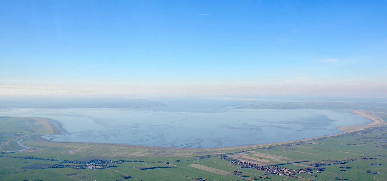
From the Air
The Jade Bight is centered at approximately 53.48°N, 8.20°E - a roughly circular bay about 15 km across, opening northward to the North Sea through a narrow neck. Wilhelmshaven sits on the western shore, the Butjadingen peninsula on the eastern. Recommended viewing altitude FL060-FL100 for the full bay shape and surrounding dike pattern. Nearest airports: Wilhelmshaven-Mariensiel (EDWI) on the western shore, Bremen (EDDW) ~50 km south. Coastal stratus is common in winter and spring.
Nearby Stories
- Broetje-Automation GmbH 4.4 km away
- Taktisches Luftwaffengeschwader 71 "Richthofen" 5.1 km away
- German Trawler V 1101 Preussen 6.6 km away
- Jümme 7.4 km away
- Großer Knechtsand 7.8 km away
- Wöbbelin Concentration Camp 180 km away
- Gardelegen Massacre 194 km away
- Lilleø 214 km away