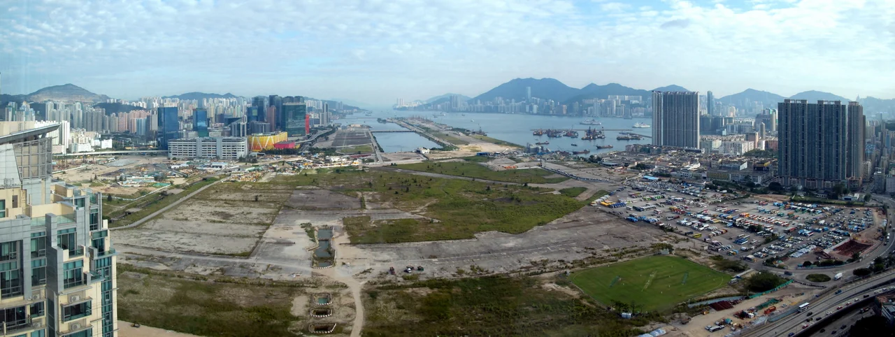

Kai Tak Airport
At roughly 650 feet, the autopilot was disconnected. The pilot watched for Checkerboard Hill — a small rise painted in aviation-orange and white squares above Kowloon Tsai Park — and then made a 47-degree right turn, descending through 140 feet to line up with the runway. The runway was surrounded on three sides by Victoria Harbour. On the fourth side, six-storey buildings rose just across a multi-lane road. Passengers could see television sets through apartment windows. At less than 150 feet, the aircraft was lower than a Boeing 767's wingspan is wide. Airline crews called it the Hong Kong Turn. Passengers called it the Kai Tak Heart Attack. It was, for 40 years, the standard instrument approach to one of the busiest airports in the world.
A Failed Investment Becomes an Airfield
The name comes not from the airport but from the people who lost money before it existed. In 1912, businessmen Ho Kai and Au Tak formed the Kai Tak Investment Company to reclaim land in Kowloon for development. The scheme failed. The government acquired the land instead and converted it into an airfield. In 1924, Harry Abbott opened the Abbott School of Aviation there. By 1928, it was a proper grass strip used by the RAF and several flying clubs — precursors to the Hong Kong Aviation Club, which still operates today. During the Japanese occupation from 1941 to 1945, prisoners of war were forced to build concrete runways on the site. In the process, the historic wall of the Kowloon Walled City and the 45-metre Sung Wong Toi — a memorial for the last Song dynasty emperor — were destroyed for building materials.
The Runway in the Harbour
The defining physical feature of Kai Tak was made by filling in Victoria Harbour. In 1958, a new runway was completed on reclaimed land, extending into Kowloon Bay at a southeast-northwest orientation. It was 2,529 metres at opening and grew to 3,390 metres by the time the airport closed in 1998. The surrounding geography made every operation a calculation. Less than four kilometres to the north and northeast, a range of hills reaches 2,000 feet. Hong Kong Island's peaks to the south rise to 2,100 feet. The runway jutted into the harbour like a pier, its northern end flanked by apartment blocks, its southern edge in open water. The noise was relentless. Buildings in Kowloon had height restrictions because of the approach path. A night curfew ran from 11:30pm to 6:30am. The airport and the city had grown into each other over decades, and neither could escape the other.
The Checkerboard Turn
No approach in commercial aviation history has been more discussed, simulated, and mourned than Runway 13 at Kai Tak. The Instrument Guidance System installed in 1974 was offset 47 degrees from the runway heading — technically a localizer-type directional aid rather than a full ILS, because a standard instrument landing system was impossible given the required turn. Inbound aircraft flew a wide arc from the southwest, lined up on the IGS guidance beam, descended to 2,500 feet before disconnecting autopilot, then dropped below 1,000 feet approaching Checkerboard Hill. Upon spotting the painted hill, the crew made the visual right turn. Entry at approximately 650 feet, exit at 140 feet, runway ahead. During typhoons, crosswinds from the northeast made the final turn genuinely dangerous. The wind changed direction as the aircraft rotated, shifting a headwind into a crosswind mid-turn. Plane spotters gathered on the rooftops of Kowloon City to watch. The approach was used most of the time because of prevailing winds. There was no alternative.
131 Deaths, One Airport
The geography that made Kai Tak dramatic also made it deadly. From 1947 to 1994, crashes killed 131 people. The deadliest was on 24 August 1965, when a US Marine Corps C-130 Hercules crashed shortly after takeoff from Runway 13, killing 59 of the 71 on board. A Thai Airways Caravelle went into Victoria Harbour on 30 June 1967 in a rainstorm; 24 people died. On 4 November 1993, a China Airlines Boeing 747-400 overran the runway in typhoon conditions and ended up submerged beyond the runway end — all 396 passengers and crew sustained only minor injuries, a near-miracle. The airport never had a catastrophic midfield collision or a runway incursion fatality. What it had was an approach that demanded everything a crew could give, every single time.
Goodbye Kai Tak
On 6 July 1998, the director of civil aviation Richard Siegel gave a brief speech in the control tower and ended with: 'Goodbye Kai Tak, and thank you.' He dimmed the lights, then turned them off. The last commercial departure had been Cathay Pacific CX251 to London Heathrow, a Boeing 747-400, which lifted off Runway 13 at 12:02am. A ferry flight to Chek Lap Kok followed at 1:05am. The new airport opened the same morning. The terminal later served as a go-kart track, a bowling alley, a mall, and a snooker hall before being demolished in the mid-2000s. On the reclaimed runway, a cruise terminal opened in 2013 at the runway tip. A Kai Tak MTR station opened in 2020. The Kai Tak Sports Park, built on the former airport land, opened in March 2025 with a 50,000-seat stadium — the largest sports venue in Hong Kong. The runway number, 13, is painted on the park's ground. On 30 March 2025, Cathay Pacific flew a commemorative flight — CX8100 — over Victoria Harbour to mark 100 years since Kai Tak's history began.
From the Air
Kai Tak Airport was located at 22.318°N, 114.202°E on the eastern side of Kowloon Bay, in what is now the Kai Tak Development Area of Kowloon. The former Runway 13/31 runs southeast-northwest (134/314 degrees true). The airport's ICAO code was VHHH (now reassigned to Hong Kong International Airport at Chek Lap Kok, 30 km to the west-southwest). From the air, the site is easily identified by the former runway peninsula jutting into Kowloon Bay, now occupied by the Kai Tak Cruise Terminal at its tip and the Kai Tak Sports Park stadium to the northwest. The Checkerboard Hill visual reference point is above Kowloon Tsai Park, north of the former runway threshold. Recommended viewing altitude 2,000–4,000 ft for context across the full Kowloon Bay site and the surrounding urban density.
Nearby Stories
- Lok Ma Chau Loop 2.3 km away
- Portas do Cerco 2.3 km away
- Kweilin Incident 17 km away
- Wanshan Archipelago Campaign 34 km away
- Nanxiong Formation 115 km away
- Battle of Nanpeng Island 148 km away
- Heyuan 169 km away
- Cape Maobitou 632 km away