
Koumbi Saleh
A single word in an old manuscript sent archaeologists into the desert. In 1913 a French scholar reading a 17th-century African chronicle came across the name of a vanished capital: Koumbi. The chronicle pointed northeast, toward a stretch of southern Mauritanian scrub where there was no rain for most of the year and no surface water at all. There, beneath low grass and thorn, lay the stone bones of a city - one that may once have been the seat of the Ghana Empire and home to twenty thousand people, though the proof that would settle the question has never been found.
The City al-Bakri Described
Five centuries before the diggers arrived, the Moorish geographer al-Bakri had already described Ghana's capital - or believed he had. Writing around 1068 from Muslim Spain, drawing on travelers' reports, he sketched a capital of two towns six miles apart. One was a Muslim merchant town, large and prosperous, with twelve mosques and wells of sweet water for growing vegetables. The other, called Al-Ghaba, was the king's town - a walled compound of domed dwellings and a palace, with sacred groves nearby where the keepers of the older religion lived. Between the two stretched continuous habitation. It is one of the most vivid portraits of any West African city of its age. The trouble is matching it to the ground.
What the Diggers Found
The ruins were first reported in 1914, and French archaeologists have returned to them across a century - Thomassey and Mauny around 1950, Robert in the 1970s, Berthier in the 1980s. What they uncovered was a substantial stone town on a low hill. The houses were built of local schist, packed close along narrow streets, many of them two storeys, their rooms kept narrow because the treeless plain offered no long timbers for roofing. A broad avenue up to twelve meters wide ran east to west across the town, and on it stood a great congregational mosque - 46 meters long, its mihrab facing due east. Two large cemeteries flanked the settlement, the sign of a place lived in for a very long time. Radiocarbon dates from charcoal near the mosque span from the late 5th to the 14th century, with the city at its height between the 11th and 14th.
Coins From Baghdad
The objects pulled from the soil told the story of a place wired into the whole medieval world. Islamic coins surfaced in numbers, along with ceramics and glassware - and some of those coins had been minted in Baghdad, four thousand kilometers and a desert away. Gold, iron, salt, ivory, and other goods had all passed through here. The French archaeologist Raymond Mauny estimated that the town once held between 15,000 and 20,000 people, then caught himself in the margin: an enormous figure, he wrote, for a Saharan town with so little water. That tension - a great city in a place that can barely sustain one - is exactly what makes Koumbi Saleh extraordinary, and what trade alone could overcome.
The Missing Inscription
And yet the identification is not certain. In recent decades scholars have grown more cautious, because the one thing that would clinch the case is absent: no inscription has ever been found tying these ruins to the capital al-Bakri named. The king's town of Al-Ghaba has never been located at all. Al-Idrisi, writing in the 12th century, placed Ghana's royal city on a riverbank and dated its palace to 1116 or 1117 - which has led some to think the capital was later moved south, nearer the Niger. One scholar has even argued the site is not Ghana's capital but the Berber town of Awdaghost. The desert keeps its answer. Koumbi Saleh is almost certainly the capital of Ghana - and that almost has survived a hundred years of excavation.
A Site Still Waiting
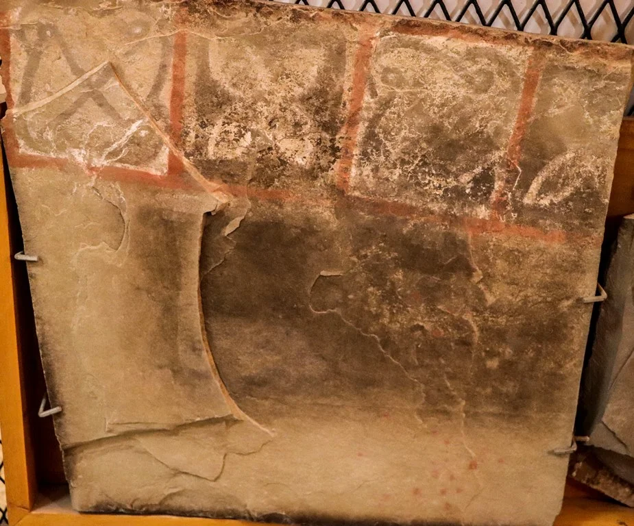
Today Koumbi Saleh sits 30 kilometers north of the Malian border, far from any city, on a plateau of grass and acacia that floods briefly in the July-to-September rains and lies parched the rest of the year. A modern commune of some eleven thousand people shares the name. The ruins themselves were placed on UNESCO's World Heritage Tentative List in 2001, recognition of a site that holds answers about one of the earliest states in West African history. The mosque still stands in outline, its painted slate slabs once carved with geometric and floral designs now studied in the National Museum in Nouakchott. The hill is higher than it was a thousand years ago, raised by the accumulated rubble of the city itself - a place that, even ruined, keeps rising slowly out of the plain.
From the Air
Koumbi Saleh lies at 15.756°N, 7.971°W in southern Mauritania, about 30 km north of the Malian border, 57 km south-southeast of Timbedra and 98 km northwest of Nara in Mali. From altitude, look for a low isolated hill - roughly 15 m above an otherwise flat plain of grass, thorn scrub, and scattered acacia - rising amid two large cemetery fields and the faint geometry of a buried town; seasonal depressions hold water only in the July-September rains. There is no airport at the site; nearest scheduled service is Nema Airport (GQNF) to the northeast, with Bamako-Senou (GABS) far to the south. Best seen in clear dry-season light; winter Harmattan haze frequently reduces visibility over the Sahel.
Nearby Stories
- Néma 70 km away
- Nioro du Sahel 124 km away
- Oualata 173 km away
- Boucle du Baoulé National Park 186 km away
- Great Mosque of Niono 201 km away
- Niono 222 km away
- Aoukar 222 km away
- Aoudaghost 282 km away