![Photo: [2] | CC BY-SA 2.0](https://commons.wikimedia.org/wiki/File:HK_Kowloon_Panorama_2009.jpg)
Kowloon
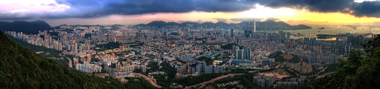
The name carries a legend. Kowloon — 九龍 in Chinese — means "Nine Dragons," and the count refers to eight surrounding mountains plus a boy emperor: Bing of Song, the last ruler of a dynasty in collapse, who stood on this peninsula in 1278 and counted the peaks around him. He reckoned eight dragons. His attendants reminded him that emperors are themselves dragons. Nine, then. He would be dead within a year, drowned at sea as the Mongols closed in. The mountains he named still stand, Lion Rock looming above the city that grew beneath them, and the name he bestowed on a few hills on the edge of a harbour now belongs to one of the most densely populated places on Earth.
From Tiger Country to Colony
When Britain acquired the southern part of Kowloon under the Convention of Peking in 1860, the peninsula was sparsely settled and, by colonial accounts, used mainly for tiger-hunting expeditions. The northern section, New Kowloon, followed in 1898 as part of the 99-year lease of the New Territories under the Second Convention of Peking. Development was slow at first. What changed everything was the railway: the Kowloon-Canton Railway opened in 1910, linking the peninsula to mainland China and transforming Tsim Sha Tsui into a proper gateway. Then came the refugee waves. Japan's invasion of China in 1937 sent 750,000 people into Kowloon and its surroundings between 1937 and 1939 alone, many of them without shelter or legal residence. The city compressed itself to accommodate them, and never fully decompressed.
A Skyline Shaped by a Flight Path
For decades, a peculiar constraint governed Kowloon's architecture: the old Kai Tak Airport sat in Kowloon Bay, and planes on approach had to thread between apartment blocks, descending steeply over rooftops before touching down on a runway that jutted into the harbour. Building heights across much of Kowloon were capped to keep the flight paths clear. The result was a low, dense, horizontal city that looked nothing like the vertical drama of Hong Kong Island across the water. Kai Tak closed in 1998. The height restrictions are gone. The skyline is still catching up with its own possibilities, though the memory of planes skimming the rooftops has become part of Kowloon's mythology.
The Walled City and Its Ghost
Within New Kowloon, a small enclave once occupied a category of its own. The Kowloon Walled City was a former Qing military outpost that fell into an extraordinary legal limbo under British colonial rule — neither fully British nor fully Chinese — and became over decades a densely packed labyrinth of ungoverned tower blocks, home to tens of thousands of people in conditions of genuine deprivation. Dentists, doctors, and small industries operated in the shadows. It was demolished in 1993 and replaced by a garden. The area is now called Kowloon City. The garden is pleasant. The Walled City's absence is as much a part of Kowloon's story as its presence ever was.
Density and Dailiness
Over two million people live in Kowloon today, across five districts: Kowloon City, Kwun Tong, Sham Shui Po, Wong Tai Sin, and Yau Tsim Mong. About 94 percent identify as ethnically Chinese, and roughly 86 percent use Cantonese as their primary language. The peninsula holds universities — Hong Kong Polytechnic, Baptist, City — alongside night markets, mosques, temples, public housing estates, and the neon-lit density of Mong Kok. Three MTR lines and two road tunnels connect Kowloon to Hong Kong Island under the harbour. No bridges. The water between them remains, as it always has, a genuine divide — crossed millions of times a day but never quite bridged.
The Lion and the Light
Lion Rock defines the northern horizon of Kowloon in the way that a single peak can define a whole city's sense of itself. The silhouette — a couchant lion in outline against the sky — is visible from street level across much of the peninsula, a natural landmark that has become a cultural one. Hikers climb it on weekends. In the evenings, from certain streets in Wong Tai Sin or Kowloon Tong, the last light catches the ridge and turns it amber. Victoria Harbour glitters to the south. Between the rock and the water lies the entire human weight of Kowloon, stacked and layered and perpetually in motion.
From the Air
Kowloon sits at approximately 22.317°N, 114.183°E, occupying the peninsula directly north of Victoria Harbour. From the air at 3,000–6,000 feet, the dense urban grid of Tsim Sha Tsui is visible at the southern tip, with Mong Kok and the airport site (Kai Tak) stretching northeast. Lion Rock (495 m) marks the northern boundary. Victoria Harbour separates the peninsula from Hong Kong Island to the south. Primary nearby airport: Hong Kong International (VHHH), approximately 28 km west on Lantai Island. The former Kai Tak Airport site is in Kowloon Bay on the eastern side of the peninsula.
Nearby Stories
- Lok Ma Chau Loop 2.3 km away
- Portas do Cerco 2.3 km away
- Kweilin Incident 17 km away
- Wanshan Archipelago Campaign 34 km away
- Nanxiong Formation 115 km away
- Battle of Nanpeng Island 148 km away
- Heyuan 169 km away
- Cape Maobitou 632 km away