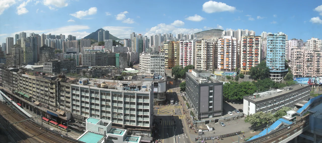

Kwun Tong
The name has changed its character but not its sound. Kwun Tong — 觀塘 — used to be written 官塘, meaning "Mandarin's Pond," a reference to the Koon Fu salt yards established during the Song dynasty when the coastline here, stretching toward Kowloon Bay and To Kwa Wan, was among the most productive salt-producing territory in the region. Koon Fu was one of the four largest salt beds in Dongguan province. When the government moved to control the trade and sent troops to enforce its monopoly, the crackdown turned violent: many islanders were killed. Salt and blood, centuries before the factories came.
First of the New Towns
When Hong Kong began its post-war industrialization in earnest, Kwun Tong was one of the first places chosen for systematic development as a "new town" — a planned community built from near-scratch to house and employ a rapidly growing population. Factory construction began in the 1950s. Textile mills, plastics manufacturers, and light industry filled the flatlands reclaimed from the harbour's edge. Workers came from across the colony and from the Chinese mainland, filling public housing estates that went up alongside the factory blocks. The industrial area eventually spread to Kowloon Bay and Yau Tong. At its peak, Kwun Tong was Hong Kong's manufacturing heartland, the kind of place that supplied the goods that made Hong Kong rich, even as the wealth itself tended to accumulate elsewhere.
Golden Street and the Man with the AK-47
Every district has its local landmarks, and Kwun Tong's Mut Wah Street — nicknamed Golden Street for the ten or so jewellery shops that once crowded it — earned its notoriety in 1992. Yip Kai-Fuen, who became one of Hong Kong's most wanted criminals, walked into the street armed with an AK-47 assault rifle and robbed five of the jewellery shops in a single armed raid. The audacity of the crime lodged it in collective memory. The street still exists. The jewellery shops thinned out. Yue Man Square, the central square that served as the commercial heart of Kwun Tong for decades, is currently being demolished and rebuilt as a shopping centre by the Urban Renewal Authority — one of several redevelopment projects that have been rewriting the district's face in recent years.
The Industrial Reckoning
As Hong Kong's manufacturing sector shifted to the Chinese mainland through the 1980s and 1990s, the factories that had defined Kwun Tong emptied out. Many were demolished; commercial towers began filling the gaps. The government recognized the pattern and responded with a formal plan: the Kowloon East regeneration initiative, which designated Kwun Tong and the adjacent Kai Tak development area as the city's "second central business district." International banks followed. Citibank (Hong Kong) placed its headquarters at One Bay East on the waterfront. Link REIT, the largest real estate investment trust listed in Hong Kong, anchored itself here too. The promenade along the coast near Kwun Tong Pier — where ferry passengers once waited for the North Point boat — has become a waterfront park.
Between Lion Rock and the Sea
Kwun Tong's geography gives it a particular sense of enclosure. To the north, the ridge that includes Lion Rock closes off the horizon. To the south and east, Victoria Harbour and Lei Yue Mun open toward the sea. The former Kai Tak Airport runway — a long spit of reclaimed land that juts into the harbour to the west — now anchors a cruise terminal that opened in 2013. The MTR's Kwun Tong line threads the district together, its station directly above the main road. More than two million people call greater Kowloon home, and Kwun Tong is one of the peninsula's most densely inhabited corners — a place shaped by salt, industry, and relentless reinvention, where the past is being demolished and replaced fast enough that the present can barely keep up with what it is becoming.
From the Air
Kwun Tong is located at approximately 22.313°N, 114.226°E on the eastern flank of the Kowloon Peninsula. From the air at 2,000–5,000 feet, the district is recognizable by its dense commercial and residential grid east of the main Kowloon urban mass, bounded by Lion Rock ridge to the north and the harbour to the south. The former Kai Tak runway is visible as a narrow promontory extending west into the harbour. Nearest major airport: Hong Kong International (VHHH), approximately 30 km west-southwest. The Lei Yue Mun strait, at the eastern approach to Victoria Harbour, is visible to the southeast.
Nearby Stories
- Lok Ma Chau Loop 2.3 km away
- Portas do Cerco 2.3 km away
- Kweilin Incident 17 km away
- Wanshan Archipelago Campaign 34 km away
- Nanxiong Formation 115 km away
- Battle of Nanpeng Island 148 km away
- Heyuan 169 km away
- Cape Maobitou 632 km away