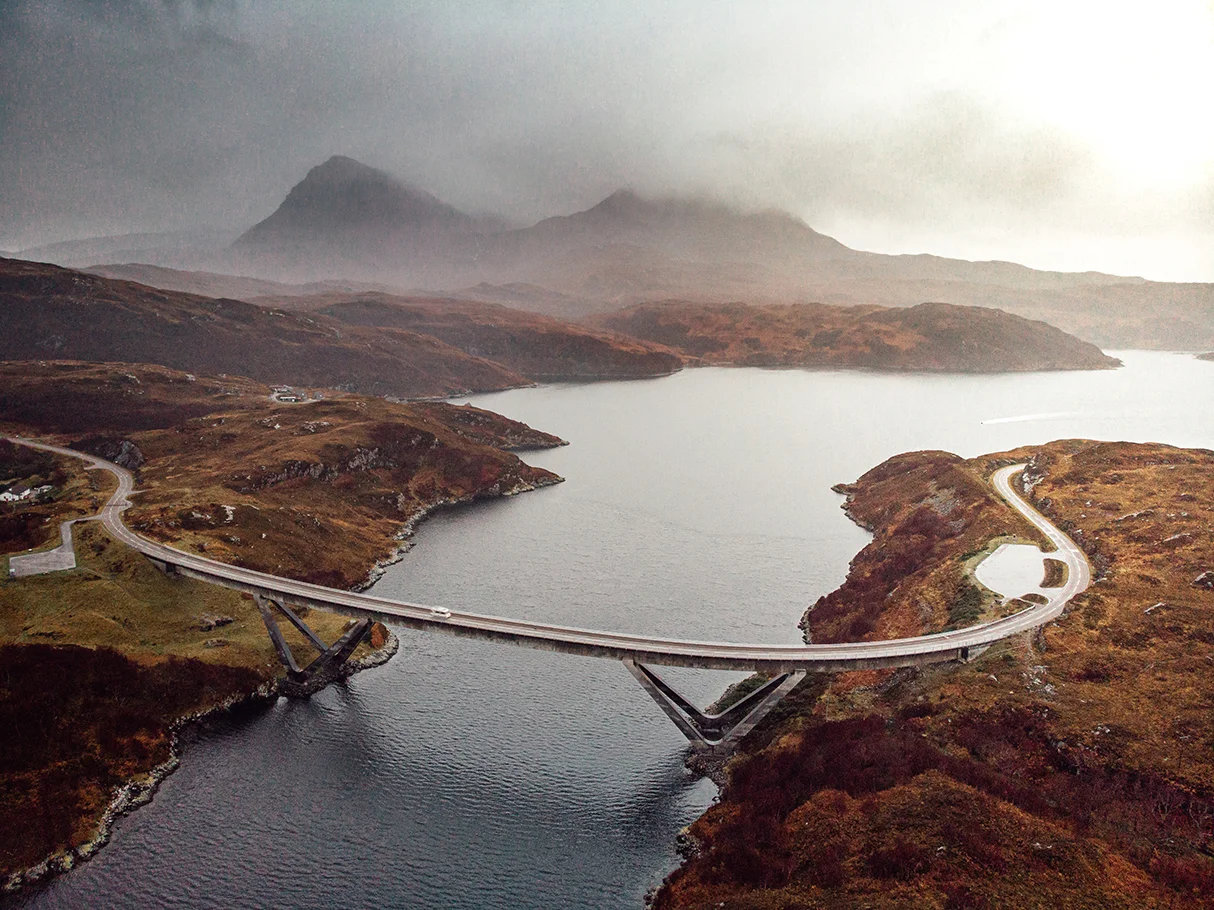

Kylesku Bridge
From the air, the bridge does something most bridges don't: it curves. Most engineers like a bridge to go straight from one bank to the other - it's stronger, cheaper, simpler. The Kylesku Bridge curves because the engineers at Ove Arup decided in 1979 that a curve fitted the landscape better than a straight line would. The result is one of the most photographed bridges in Scotland, the elegant signature of the North Coast 500 driving route, and - as of 2019 - a Category A listed structure recognised by Historic Environment Scotland as 'visually striking and technically innovative'. It cost £4 million in 1984 money. It replaced a ferry that had crossed the strait for centuries.
Caolas Cumhann, the Narrow Strait
The water beneath the bridge is called Caolas Cumhann - Gaelic for 'narrow strait', pronounced approximately 'Kyles Cuan'. It connects Loch Glencoul and Loch Glendhu inland with Loch a' Chairn Bhain that opens onto the Minch. The channel is about 120 metres wide and up to 25 metres deep, which produces fast tidal currents that change direction four times a day. The ferry that the bridge replaced ran about 400 metres east of the present bridge site, between the small villages of Kylesku on the south side and Kylestrome on the north. In rough weather or at peak tides, the ferry would stop. For a remote part of Sutherland with no alternative road, this was a recurring problem.
The Engineering Choice
In June 1978 Highland Regional Council asked Ove Arup & Partners Scotland to study whether a bridge made sense. By March 1979 the feasibility study was complete. The engineers settled on a curved concrete box girder design with V-shaped inclined piers. The curve allowed the approach roads to follow the contours of the land rather than carve new cuttings through the hillsides. The V-shaped piers - eight inclined legs in total - reduced the length of the main span and balanced their lateral forces so that the total force on the foundations pointed straight down. The bridge is 276 metres long with a 79-metre main span. The deck sits 24 metres above high water to give navigation clearance for ships entering the lochs. The legs are reinforced concrete, the deck prestressed concrete tensioned to forces up to 52,200 kilonewtons.
The Build
Approach roads cost £4 million and began in summer 1981. The bridge itself started in August 1982. The main contractors were Morrison Construction and Lehane, Mackenzie and Shand. The total bridge cost £4 million against an initial budget of £2.75 million - an overrun of about 45 percent, modest by the standards of public works of that era. Construction had to deal with high winds, fast tidal currents, and the practical challenge of casting curved sections over deep water in a remote part of Scotland. The bridge opened to traffic in July 1984. Queen Elizabeth II formally opened it on 8 August 1984.
Listed in 2019
In 2019, Historic Environment Scotland did something unusual: it Category-A listed a bridge that was only 35 years old. Category A is the highest grade of architectural protection in Scotland, normally reserved for buildings of national or international significance. The citation called Kylesku 'visually striking and technically innovative' - rare praise for late-twentieth-century infrastructure. At the same ceremony, the bridge was officially renamed by its Gaelic title, Drochaid a' Chaolais Chumhaing. The listing recognises something the engineers had aimed for from the start: that a bridge designed to be sympathetic to its setting could, after a generation of weathering, become part of that setting rather than an intrusion on it. Today the curve is one of the iconic images of the North Coast 500 driving route, photographed thousands of times each summer.
From the Air
Kylesku Bridge crosses Caolas Cumhann at 58.257°N, 5.024°W on Scotland's far northwest coast. From the air it appears as a graceful concrete curve spanning a narrow strait between two larger sea lochs. Nearest airport is Inverness (EGPE), 80 nm to the southeast. Recommended viewing altitude 1,500-3,000 ft to take in the bridge, the meeting of Loch Glencoul and Loch Glendhu inland, and Loch a' Chairn Bhain opening westward toward the sea. The bridge sits within the North West Highlands Geopark and is a navigation landmark for the North Coast 500 driving route.
Nearby Stories
- Sandwood Bay 2.1 km away
- Coigach 5.6 km away
- German submarine U-905 8.9 km away
- Loch Naver 11 km away
- Falls of Shin 11 km away
- Rua Reidh Lighthouse 20 km away
- HMS King Edward VII 29 km away
- Tiumpan Head Lighthouse 30 km away