La Macarena
In La Macarena, the day of rest is not Sunday. The town sits at the edge of Colombia's eastern plains, where cattle herders called campesinos come into town on weekends to buy supplies, so Sunday cannot be the local sabbath. The town picked Wednesday instead. Walk down the main street on any Wednesday and you will find ninety percent of the businesses closed. The local population is under four thousand people. The town exists for one reason: to serve as the only practical gateway to Cano Cristales, a small river in the Serranita de la Macarena that botanists call the Liquid Rainbow.
The River of Seven Colors
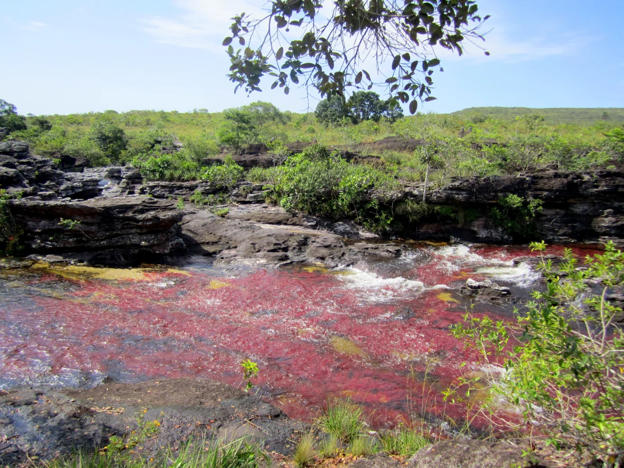
Cano Cristales is not wide. It is not long. For most of the year, it is not even particularly colorful, a clear stream running through a stone-bed canyon in one of the most biodiverse hectares on Earth. But between July and November, the stream's riverbed erupts into reds, yellows, greens, blues, and blacks. The color comes from an aquatic plant called Macarenia clavigera, which grows directly on the rock bed of the river. When sunlight hits the plant in shallow, clear water, it flushes a deep red. Other species contribute their own pigments. Together they make what travel writers have called the most beautiful river in the world. For a spectacular display of color you also need sunny weather, most likely between September and February. The four-month bloom defines the region's entire tourism calendar.
The Serrania, and Its Dangers
The river lives inside the Serrania de la Macarena, a plateau that rises out of the flatness of Los Llanos, the eastern plains. Colombia declared it a natural reserve in 1948, its first, and it is now a national park. The Serrania is possibly the single most biodiverse spot on Earth measured per hectare. Its altitude ranges bring scrub grasslands, dense jungle, and borderline Andean habitats together, all under temperatures that stay between twelve and twenty-five degrees Celsius year-round because of the equatorial location. Anteaters, jaguars, cougars, deer, eight species of monkeys, 550 species of birds, 1,200 species of insects, and more than 100 species of reptiles live inside it. The park is threatened, however, by slash-and-burn agriculture practiced by poor colonos trying to survive in Los Llanos, and by coca cultivation in its remote corners. Government fumigation of coca fields has contributed to the ecological damage it was meant to prevent.
El Refugio, DMZ, National Park
The Serrania's indigenous Guayabero people lived here since prehistoric times. The first non-Indigenous settlement came in the 1950s, when colonos, the Colombian term for frontier settlers, arrived from the department of Caqueta and founded a town they called El Refugio. The name fit. Between 1999 and 2002, during the Colombian peace negotiations, La Macarena and its surroundings became part of El Caguan, a demilitarized zone granted to the FARC guerrilla movement as sole authority during talks. Locals who volunteer their opinions describe those years, and the years just before and after, as frightening. The national military did not have full control of the area. Since the peace agreement and the ongoing disarmament of the FARC, La Macarena has become safer, protected by visible military presence in the town and around the tourist trails. The town's new career as a tourism gateway is part of the peace's dividends.
Getting In, and What It Costs
There is one safe way to reach La Macarena, and it is by airplane. Satena, the state airline, runs flights from Bogota into a small airstrip that looks more like a backyard than an airport. Overland travel is possible, but the roads are bad enough to be impassable in rainy season. Most visitors book a complete package tour from Bogota. For three full days, including flights, accommodation, food, and all park activities, the price runs roughly 1,200,000 to 1,400,000 Colombian pesos. Cano Cristales is one of the rare destinations that is both easier and cheaper to visit through a tour than on your own. Guides are mandatory inside the park, partly to protect the river. Tour prices within the park run 250,000 to 350,000 pesos per day. No sunblock or insect repellent is allowed in the park, because they damage the delicate aquatic plants. Long sleeves and long pants become essential.
The Walk to the Color
Getting to Cano Cristales from town starts with a boat across the Guayabero River, then a jeep, bicycle, motorcycle, or horse for most of the way in. The final approach is on foot. Guides lead groups through the savanna to the river's different sections, some of which have nicknames: Cristalitos, the little crystals, and Cano Piedra, stone river. A typical three-day package covers Cano Cristales on one day and alternate sites on the others. The best memories for most visitors are the swims in the natural pools below the waterfalls. The water has the exact temperature you want it to have, cool enough to refresh, warm enough to stay in as long as you like. You can touch the Macarenia clavigera gently in the river. Do not kick it or grab it. Tourism is the town's new economy, and the plants are how the town earns its living.
A Sleepy Town at the Edge
When you are not walking to the river, La Macarena is a very quiet place. The town's population lives around a single main square with a church and a park. Pool halls on the corners of Calles 6 and 7 stay open late, serving Aguila and Poker beers. Restaurants offer simple food at low prices, with a large number of panaderias selling arepas. A traditional Llanero music and dance show runs every evening at 7 PM to welcome new arrivals. Hotel San Nicolas, around the corner from the airport, hosts the longer version. The internet is famously slow. The ATM is run by Banco Agrario, charges high fees, and sometimes cannot be stocked because of power outages. Bring cash. Bring malaria medication. Get vaccinated against yellow fever more than ten days before you travel. This is lowland Colombia. The safety within the town is good. The isolation, and the river at the end of it, is what you came for.
From the Air
Located at 2.18 degrees North, 73.79 degrees West, in the southern part of the Meta department, Colombia. La Macarena sits at roughly 240 meters elevation along the Guayabero River, at the base of the Serrania de la Macarena. The Serrania rises to roughly 2,200 meters, an isolated plateau south of the Andes and east of the central mountain range. Nearest airport: La Macarena Airport (SKNA), a small airstrip with limited commercial traffic (Satena). El Dorado International (SKBO) at Bogota is the regional hub, roughly 250 km northwest. Recommended viewing altitude: FL100 to FL180 for the Serrania set against the vast flatness of Los Llanos extending east to the Venezuelan border. The color of Cano Cristales is not visible from cruising altitudes; the river is narrow and requires ground-level observation. Best aerial weather: clear days during September-February when the region has the most sunshine.
Nearby Stories
- San Vicente del Caguán 66 km away
- Operation Jaque 120 km away
- Villavicencio 187 km away
- Tolima Department 213 km away
- San Agustín culture 234 km away
- Cuyabeno Wildlife Reserve 333 km away
- Sun Temple of Sogamoso 362 km away
- Great Depression in Latin America 409 km away