The Lake That Swallowed a Valley
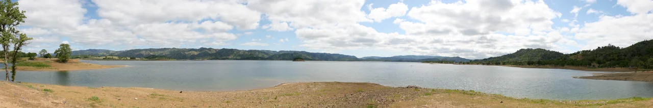
There is a hole in Lake Berryessa that swallows water whole. Near the southeast shore, a concrete funnel 72 feet across opens its mouth to the sky, and when the reservoir fills past capacity, water pours over the lip and drops 200 feet straight down before narrowing into a 28-foot pipe and vanishing underground. They call it the Glory Hole, and in 1997, a woman swimming nearby was pulled into its current and killed. But the Glory Hole is only the most visible of the lake's appetites. Beneath these 20,000 acres of water lies an entire valley -- farmland, orchards, roads, and the town of Monticello, all deliberately drowned in the 1950s to create Napa County's largest reservoir.
Death of a Valley
The land that became Lake Berryessa was Pomo territory long before it carried a Spanish name. The Berryessa family received Rancho Las Putas from the Mexican government in 1843, and for a century afterward the valley was an agricultural region whose soil was considered among the finest in the state. Families farmed it, towns grew in it, and a community called Monticello anchored its civic life. Then the Bureau of Reclamation came. Construction of Monticello Dam began in 1953, and by 1958 the concrete wall stood 304 feet high across Putah Creek. Residents were relocated. Buildings were demolished or left to the rising water. Photographers Dorothea Lange and Pirkle Jones documented the displacement in their 1960 work "Death of a Valley," published in Aperture magazine -- images of empty farmhouses and uprooted lives that remain some of the most haunting records of what reservoir construction costs the people who lived there.
The Reservoir That Skeptics Doubted
Some predicted the dam would fail and the valley would never fill. They were wrong. By 1963, the reservoir had reached capacity, creating what was then the second-largest in California after Shasta Lake. The Solano Project, as the system of dams and distribution infrastructure is called, began supplying water and hydroelectricity to the North Bay region of the San Francisco Bay Area. Governor Edmund G. Brown soon proposed the "Greater Berryessa Project" -- a 600-foot dam capable of holding ten times the water, which would have tripled the lake's size and flooded productive farmland far beyond the original footprint. The plan's purpose was to store northern water for southern California, a perennial California conflict. It was never built. The existing lake, with its 304-foot dam and its Glory Hole spillway rated for 48,000 cubic feet per second, proved sufficient. A 1986 study found that the probability of the water level reaching 450 feet was one percent -- a once-in-a-century event. The highest level ever recorded was 446.7 feet.
The Zodiac at Lake Berryessa
On the evening of September 27, 1969, Pacific Union College students Bryan Hartnell and Cecelia Shepard were picnicking on a small island connected by a sand spit to Twin Oak Ridge when a man approached them. He wore a black executioner-style hood with clip-on sunglasses over the eye holes and a bib bearing a white cross-circle symbol. Claiming to be an escaped convict from Montana, he forced Shepard to tie Hartnell's hands, then tightened the bonds himself and stabbed them both repeatedly with a knife. Afterward, the killer walked to Hartnell's car and drew his cross-circle symbol on the door with a felt-tip pen, writing the dates and locations of his previous crimes beneath it. He called the Napa County Sheriff from a pay phone 27 miles from the scene, and when officers traced the call, they found the receiver still dangling. They lifted a palm print but never matched it. Hartnell survived. Cecelia Shepard died two days later, never regaining consciousness. The case remains unsolved.
A Contested Shore
For decades, seven lakeside resorts operated under 50-year concession contracts with the Bureau of Reclamation, and some 1,300 long-term trailers lined the shores. When those contracts expired in 2009, federal rules against exclusive occupancy of public recreation land forced the trailers out. The resorts closed or scaled back, and visitation dropped by more than half. A 2015 open bid for new concession operators attracted no successful proposals. The lake that had once buzzed with waterskiers, houseboats, and weekend anglers grew quieter. Day-use areas at Oak Shores and Smittle Creek remained open, and the Narrows -- the narrow stretch nearest the dam -- still draws boaters on summer weekends. Seaplanes land on designated areas of the lake surface, though a small airstrip on one of the larger islands was shuttered in the early 1970s after an FAA safety review.
Wild Edges
The lake's eastern shore holds a 2,000-acre Wildlife Management Area where mountain lions, black-tailed deer, golden eagles, and osprey share habitat with western rattlesnakes and wild turkeys. Adjoining the reservoir is the Cedar Roughs Wilderness, 6,350 acres of terrain so thickly covered with Sargent's cypress that hiking without trails borders on bushwhacking. The cypress -- the second most widely distributed in California, named for Charles Sprague Sargent, founder of Harvard's Arnold Arboretum -- covers 3,000 acres in stands so genetically pure that botanists study them as a baseline for the species. It is a landscape of contradictions: a man-made lake surrounded by genuinely wild country, a drowned valley ringed by undisturbed wilderness, a place where the Bureau of Reclamation's concrete and the Bureau of Land Management's roadless acres exist side by side.
From the Air
Located at 38.57N, 122.24W in the Vaca Mountains of Napa County, California. Lake Berryessa is a prominent elongated body of water oriented roughly north-south, approximately 15 miles long, easily identifiable from altitude. The Monticello Dam is visible at the southeastern end, and the Glory Hole spillway appears as a dark circle in the water near the dam. The lake sits in a valley between rolling oak-covered hills. Nearby airports include Napa County Airport (KAPC) approximately 20nm southwest, Nut Tree Airport (KVCB) approximately 15nm southeast, and University Airport (KEDU) near Davis approximately 25nm southeast. The Cedar Roughs Wilderness borders the lake's northeast shore. Seaplane operations occur on the lake surface.
Nearby Stories
- Yolo Causeway 2.3 km away
- Eight Acres for a Plant That Exists Almost Nowhere 2.9 km away
- The Stone Chapel That Survived Everything 9 km away
- Where Carlin Took His Last Bow 11 km away
- Locke: The Town They Built But Could Not Own 14 km away
- Rico Harris 14 km away
- The Fence That Ran to the Sea 20 km away
- Sutter Hock Farm 22 km away