Lands End (San Francisco)
The trail follows the old railbed, which is the first thing you need to understand about Lands End. This windswept promontory at the mouth of the Golden Gate was never meant to be walked. It was built to be ridden, on the narrow-gauge cars of the Ferries and Cliff House Railway, which once carried Victorian-era pleasure seekers along these cliffs to the Sutro Baths below. The railway is gone, the baths are ruins, and the Yelamu Ohlone people who lived here before any of it arrived left no structures at all. What remains is the raw edge of a city that has always been defined by its relationship to the sea.
Rails Along the Precipice
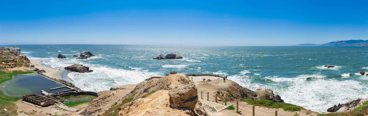
The most traveled path in Lands End is the Coastal Trail, a section of the California Coastal Trail that follows the railbed of the old Cliff House Railway. The trail is wheelchair-accessible to Mile Rock Overlook and bikeable to the Eagles Point steps. Beyond that, a spur trail descends to Mile Rock Point and Mile Rock Beach, where the views of the Golden Gate are unobstructed and the wind can knock you off balance. The San Francisco Crosstown Trail terminates here, meaning you can walk from one end of the city to this dramatic finish. Hikers pass the ruins of the Sutro Baths, the skeletal remains of Adolph Sutro's massive saltwater swimming complex that burned in 1966. Shipwrecks are visible at low tide from the Coastal Trail, their rusting hulls emerging from the surf like warnings about the rocks that claimed them.
Coal, Ghosts, and Ohlone Memory
The Yelamu Ohlone tribe lived at Lands End before Spanish settlement began in 1776. No structures survive, but the landscape they knew, the wind-sculpted cypress, the surge channels, the rocky coves, has not fundamentally changed. In 1891, a miner named Charles Jackson announced he had discovered bituminous coal under the cliffs at Dead Man's Point, on land belonging to Adolph Sutro. Sutro had a tunnel dug two hundred feet under the railroad track and confirmed the find, but the mine was never exploited. The coal still lies beneath the cliffs, alongside the bones of ships and the memory of a people who needed neither coal nor railways to call this place home.
The Geography of Approach
Lands End sits within the Golden Gate National Recreation Area, adjacent to Lincoln Park with its city-owned golf course and the Legion of Honor museum. Fort Miley, now largely occupied by the San Francisco VA Medical Center, flanks the eastern side. The Coastal Trail connects the wealthy Sea Cliff neighborhood at 32nd Avenue to Point Lobos Avenue, where the park meets Sutro Heights and the Cliff House. Several promontories along the coast have been critical navigation landmarks for ships approaching the Golden Gate. Point Lobos, sometimes called Parallel Point after a schooner shipwrecked there in 1887, sits on the far west side. Tunnels that once delivered seawater to the Sutro Baths are cut through its headland. The geography is deceptively complex: what looks from a distance like a smooth coastline reveals itself, on foot, as a maze of coves, headlands, and surge channels.
The Vanishing Labyrinth
In 2004, local artist Eduardo Aguilera constructed a stone labyrinth along the Coastal Trail, overlooking the Golden Gate Bridge. It was not authorized by the park service. It was vandalized repeatedly. It was destroyed in August 2015 and rebuilt a month later by Aguilera and roughly 200 volunteers. As of 2021, the labyrinth has ceased to exist. Its impermanence was, perhaps unintentionally, its most honest statement about Lands End. Everything here is temporary: the railways, the baths, the ships, the labyrinths. The cliffs remain, shaped by the same Pacific waves that shaped them before the Yelamu arrived. The visitor center, Lands End Lookout, opened in 2012 and offers the most accessible views. But the real experience is farther along the trail, where the city falls away and there is nothing between you and the Farallon Islands except thirty miles of cold ocean.
From the Air
Located at 37.79°N, 122.51°W on the northwestern tip of the San Francisco Peninsula, at the mouth of the Golden Gate. The rocky promontory and adjacent Lincoln Park are visible from altitude as a green headland between the Pacific Ocean and the entrance to San Francisco Bay. Nearest airports: SFO (KSFO, 14 nm south), Oakland (KOAK, 16 nm east). The Golden Gate Bridge is approximately 1.5 nm to the northeast.
Nearby Stories
- The Nonprofit That Saved Marin's Movie Palaces 0.8 km away
- Alviso, San Jose 2.2 km away
- From Ammunition Bunkers to Cattle Country 2.9 km away
- Purisima Creek 9.2 km away
- Niles Canyon Railway 15 km away
- Cordell Bank: The Invisible Island 30 km away
- The Hole in the Head 67 km away
- ʻAkaka Falls State Park 3665 km away