_-_closeup.jpg)
Landsborough's Blazed Tree (Camp 69)
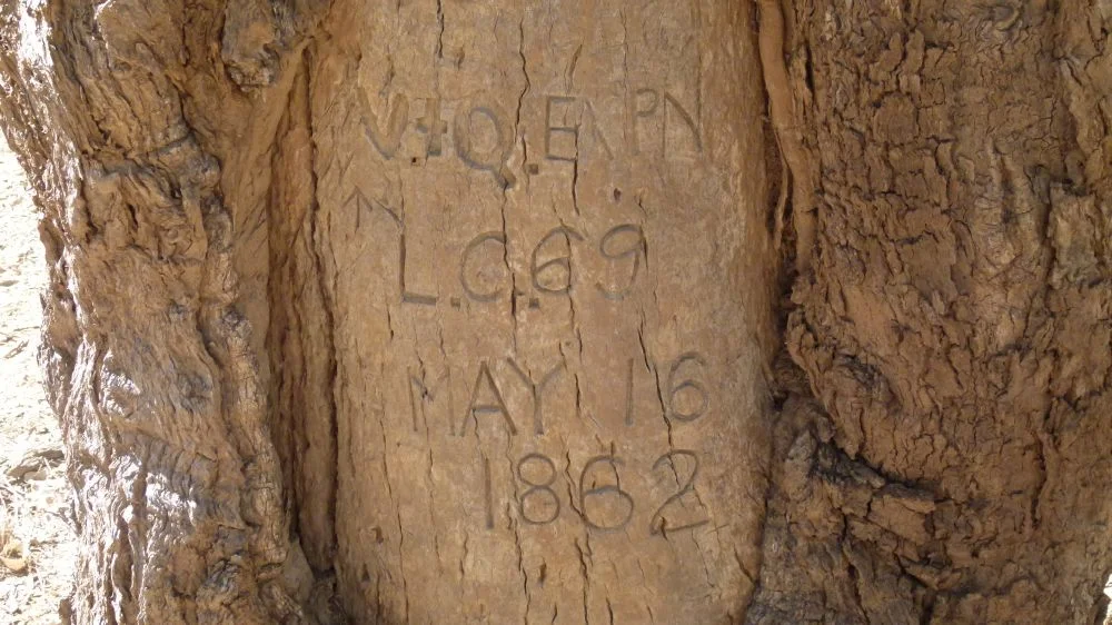
Out near Bakers Bend, 29 kilometres south of Charleville, a coolibah tree stands in grazing country with a story carved into its bark. Cut into the trunk are the letters and numbers V.+Q. EXP, N.L., C.69, MAY 16 1862. The lettering changes halfway through, the broad strokes of the V and Q giving way to a finer hand, as though one man began the blaze and another finished it. The mark was made on an existing Aboriginal scar, a wound the tree had already grown around once. On the evening of 15 May 1862, a starving party of six men and twenty horses made camp on the bank of a creek here. By the time they rode out the next morning, they had left this tree to remember them, and against every odd, it has.
The Men Sent to Find the Dead
The blaze belongs to William Landsborough, a Scottish clergyman's son turned bushman, and to a search that had already become a recovery. Robert O'Hara Burke and William Wills had set out from Melbourne in August 1860 to cross the continent from south to north; by June 1861 they were reported missing. Four relief expeditions fanned out to find them. Landsborough's was appointed in Brisbane, sailed for the Gulf of Carpentaria in the brig Firefly, and was nearly lost when the ship wrecked in September 1861, the party rescued three days later. Unknown to Landsborough, another searcher, Howitt, had already learned the men's fate in September 1861. The news simply could not reach the expeditions already in the field. Landsborough would search for the living long after they were dead.
South Across a Continent
From a depot on the Albert River, Landsborough turned his party south on 10 February 1862. The southern expedition was a small one: Landsborough in command, his deputy George Bourne, the sailor-turned-cook Gleeson, and three skilled bushmen on whom everything would depend, Jemmy, a Native Police trooper from Deniliquin, and the Aboriginal guides Jacky and Fisherman. It was Fisherman's job to blaze the trees at each camp. They followed the river systems south for months, averaging just over twenty miles a day, and as Landsborough later wrote, the marking of trees could not be overrated: the marks should be made on strong, healthy trees, at conspicuous points, the directions unmistakably clear. Camp 69's coolibah was one in a long chain of such signposts, a route home cut into living wood across half of Queensland.
The Knowledge That Kept Them Alive
Landsborough crossed the continent and was feted in Melbourne as the first to do so from north to south. But the expedition's survival was not his alone. His own journal admits it plainly: he rarely travelled without Aboriginal guidance, and his pages fill with local people leading the party to water, showing the best route, reading a country the Europeans could not. The proof came in the negative. Near here, in mid-May 1862, Landsborough struck out south-east from the Warrego without local guides. The horses went 72 hours without water and travelled 120 miles before water was found, and the party came close to perishing. Jemmy, who had rolled into a campfire and badly burned his back, was nursing the injury when they reached this creek on 15 May. The men who carved this tree were starving, scorched, and alive only because of knowledge that was not their own.
What the Tree Remembers
Six days after leaving Camp 69, the party reached a station and learned the truth: Burke and Wills had perished. Both Landsborough and Bourne recorded their surprise, having found the country so well watered. Landsborough's reports of good pastoral land set off a rush for the Gulf country and soon a rumour that he had cared more for finding grass than for finding men, a charge he denied to the end, never claiming a lease on the land he had crossed. He died at Caloundra in 1886. Of the trail of blazes he left from the Gulf to the Warrego, almost none survive; fire, flood, termites and clearing took the rest. Only two are known in the Charleville district, at Camp 67 and here at Camp 69, their lettering still sharp. The tree was added to the Queensland Heritage Register on 18 June 2009, a relic that grew through a wound and kept the date legible for more than a century and a half.
From the Air
Landsborough's Blazed Tree (Camp 69) stands at approximately 26.68 degrees south, 146.16 degrees east, on a grazing leasehold near Bakers Bend off the Mitchell Highway, about 29 km south of Charleville. The tree is a single coolibah near a tributary of the Warrego River system, impossible to identify from the air against surrounding scrub, so navigate by the larger features: the Mitchell Highway running south from Charleville and the pale threads of the Warrego catchment. The nearest airport by far is Charleville (YBCV, elevation about 1,003 ft) just to the north; Roma (YROM, about 1,027 ft) lies further east. Terrain is low, flat mulga and grazing country. Clear, dry conditions give the best view of the highway and creek lines; afternoon heat haze is common in summer.
Nearby Stories
- Cooladdi 8.5 km away
- Bowra Sanctuary 39 km away
- Koroit opal field 80 km away
- Yapunyah waterhole 158 km away
- Augustus Charles Gregory 198 km away
- Carnarvon Gorge 217 km away
- Hornet Bank Massacre 296 km away
- Jimbour Homestead 459 km away