Lanyang Museum
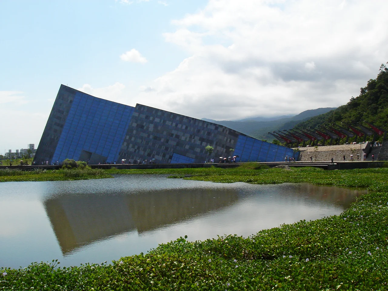
The building looks like it is falling into the earth. Tilted at a sharp angle beside Wushi Harbor in Toucheng Township, the Lanyang Museum rises from a wetland like a geological formation that decided to become architecture. Its sloping walls echo the cuesta landforms - angled rock outcrops created by differential erosion - that characterize the northeast Taiwan coast just meters away. The architect, Kris Yao of Artech, did not design a building that sits on the landscape. He designed one that emerges from it, as if the museum had been there all along, waiting for someone to notice.
The idea for this museum began in 1989, when local Yilan officials proposed a repository for the region's cultural and natural heritage. It took twenty-one years, two name changes, and a planning process involving the National Museum of Natural Science and National Taiwan University before the doors finally opened to the public on October 16, 2010.
Two Decades in the Making
Institutions that take twenty years to build carry the weight of every delay. The museum began as a proposal called the Kailan Museum in 1989. By December 1992, the Yilan County Government had formed a preparatory committee and chosen the name Lanyang Museum - Lanyang being the historical name for the Yilan region, derived from the Lanyang River that bisects the plain. The site selection placed the museum near Wushi Harbor in Toucheng, where fishing boats still work the waters and the coastline curves dramatically between mountain and sea. A planning team from the National Museum of Natural Science and the Building and Planning Research Foundation of National Taiwan University spent from 1994 to 1995 developing the overall concept. Artech won the design and construction contract in April 2000. Groundbreaking finally came on July 31, 2004, and construction began the following day. The first phase opened on May 18, 2010, accepting only pre-booked group visits - a soft launch for a project that had tested the patience of an entire county.
Mountain, Plain, and Sea
The museum's permanent exhibitions organize Yilan's story along the same geographic logic that shapes daily life in the county: mountain, plain, and sea. Yilan County is defined by these three zones. To the west and south, the Xueshan Range and the Central Mountain Range create a dramatic wall of peaks that isolates the county from the rest of Taiwan. Between the mountains and the coast, the Lanyang Plain stretches flat and green, fed by rivers carrying snowmelt and monsoon rain. To the northeast, the Pacific Ocean meets the island in a coastline of rocky headlands, fishing harbors, and surf. The museum walks visitors through all three zones, using topographic models, artifacts, and multimedia to explain how geography determined everything from agriculture to architecture, from trade routes to typhoon survival. The collection includes 1,924 artifacts transferred from the Yilan County Cultural Affairs Bureau in 2001, supplemented by traditional boats - a Wangye Boat, a Bozai Boat, and a tri-wheeler - donated in a 2003 ceremony.
Architecture as Landscape
Artech's design for the Lanyang Museum is the kind of building that architectural publications notice. Arch Daily featured it in 2012, and Smithsonian Magazine listed it among ten essential museums across Taiwan. The structure's defining feature is its tilt - the main volume leans at an angle that mirrors the nearby cuesta formations, geological features created when layers of hard and soft rock erode at different rates, producing sloped surfaces. The building's exterior cladding plays with this geological reference, using patterns of stone and metal that suggest stratified rock layers. From a distance, particularly from the harbor or the nearby train line, the museum appears less like a constructed object and more like something the coastline produced on its own. The surrounding wetlands complete the illusion, blurring the boundary between building and ground. Water reflects the angular walls. Grasses grow close to the foundation. The parking lot and entrance road arrive almost apologetically, as if reluctant to interrupt the dialogue between architecture and terrain.
Harbor Light
Wushi Harbor, just steps from the museum, remains a working fishing port. The proximity matters - it grounds the museum's cultural narrative in present-day reality. Fishermen still launch from this harbor into the Pacific currents that have sustained the Yilan coast for centuries. Toucheng Station on the Taiwan Railway sits a short walk to the southwest, connecting the museum to Taipei and the rest of the island's rail network. For visitors arriving by train, the walk to the museum passes through a landscape that the museum itself explains: the flat plain giving way to the harbor, the harbor giving way to the tilted headlands of the coast, the coast giving way to open ocean. By the time you reach the entrance, the museum has already begun its lesson. Geography is not background here. It is the entire story.
From the Air
Located at 24.87°N, 121.83°E near Wushi Harbor in Toucheng Township, Yilan County, northeastern Taiwan. The museum's distinctive tilted angular form is visible from low altitude along the coastline. Wushi Harbor, a working fishing port, sits immediately adjacent. The museum is approximately 60km east-northeast of Taipei. Taipei Songshan Airport (RCSS/TSA) is about 55km to the northwest. Taiwan Taoyuan International Airport (RCTP/TPE) lies roughly 90km to the west. The northeast coast of Taiwan features dramatic headlands and cuesta rock formations that inspired the museum's architecture. Toucheng railway station provides ground access. The Lanyang Plain stretches to the south and west, backed by the Xueshan Range. Weather is often overcast with frequent rainfall, particularly during the northeast monsoon season.
Nearby Stories
- Daxi Wude Hall 0.9 km away
- National Museum of Marine Science and Technology 1.8 km away
- Suao 3.6 km away
- Mount Dabajian 16 km away
- 2022 Chinese Military Exercises Around Taiwan 82 km away
- Sinking of MV Sewol 1068 km away
- Yellow Sea 1128 km away
- Sibuyan Island 1356 km away