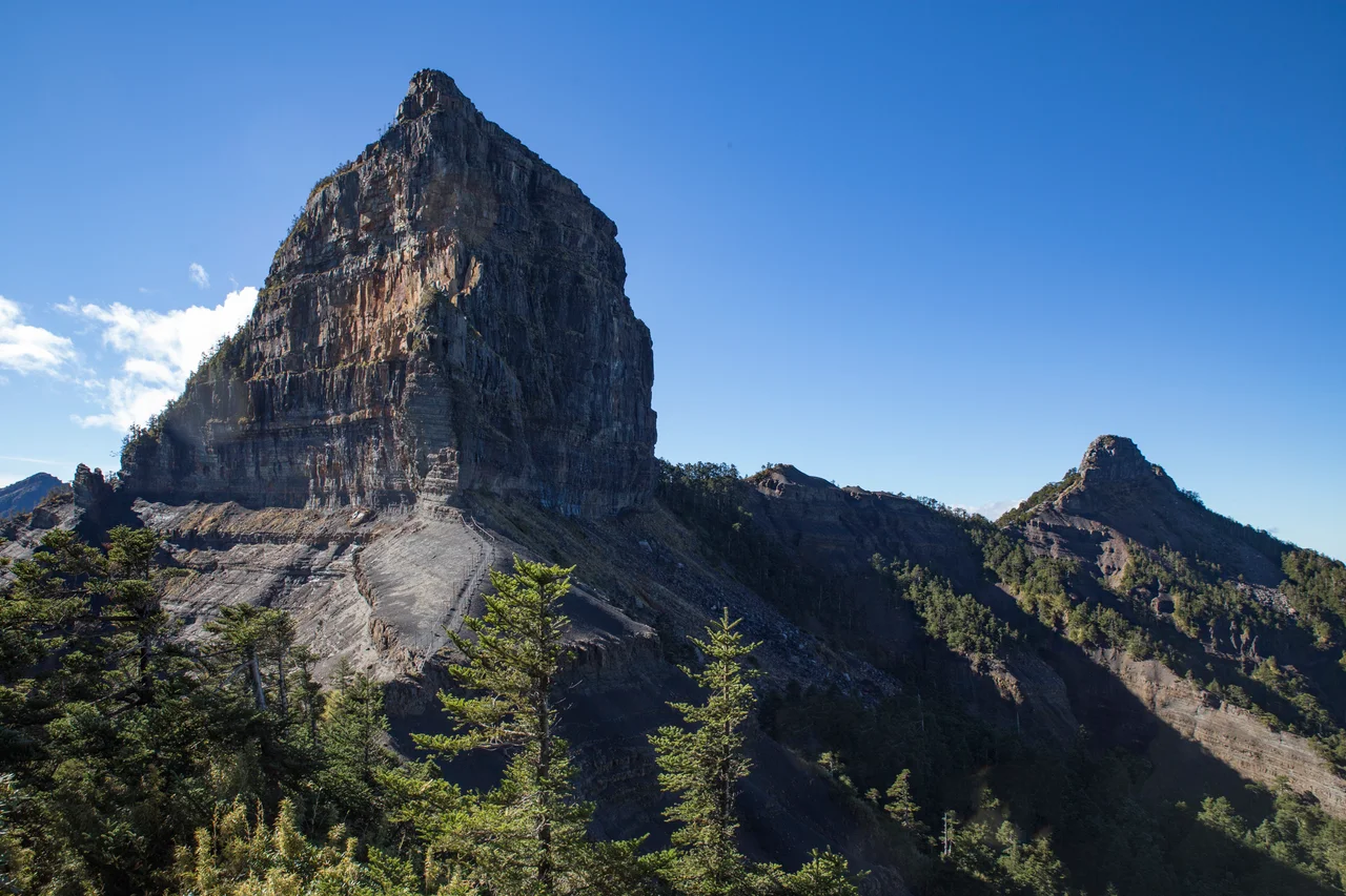

Mount Dabajian
You can see it from far away, and you cannot mistake it for anything else. Most mountains taper to a point. Dabajian ends in a wall. The lower half of the peak rises on a moderate slope like any high-country ridge, but then the mountain changes its mind. The upper portion becomes nearly vertical — a sheer rock face approximately 150 meters high and 100 meters wide, dropping on all sides. Japanese mountaineers who first saw it from a distance compared the silhouette to a Turkish fez. Taiwanese climbers call it the Marvelous Peak of the Century. The Atayal and Saisiyat peoples, for whom this mountain is far older than any of those names, regard it as something closer to the center of the world.
Ancestral Mountain
For the Atayal people, Mount Dabajian — which they call Papak Waqa, meaning 'rock split like an ear' — is not simply a landmark. It is where their ancestors originated. Their traditions hold that souls of those who lived well traveled through this mountain after death. Water flowing from Dabajian was understood as the source of all natural life. When Japanese mountaineer Numai Tetsutaro organized the first recorded ascent in 1927, his Atayal guides refused to participate. Tetsutaro reached the summit by evading them. That first ascent was not, in Atayal understanding, a triumph — it was a violation. The Saisiyat people hold a different but equally deep relationship. Their name for the mountain is Kapatalayan, meaning 'the place where the vessel got stuck.' In the Saisiyat flood creation myth, when a great deluge covered the world, two Saisiyat siblings survived by drifting to the summit in a weaving loom. When the waters receded, they descended and spread throughout the region. The mountain that saved them became the mountain that defined them.
Shape and Stone
The visual drama of Dabajian comes from its structure. The lower half rises at roughly 35 degrees — steep but hike-able, moving through forest and then into the high alpine zone. The upper half simply stops being a slope. The vertical face on every side is composed primarily of greywacke — dark, hard sedimentary sandstone and siltstone — shaped by millennia of wind erosion into its distinctive form. Neighboring Xiaobajian peak stands approximately 700 meters away and is similarly dramatic. Together, the two peaks resemble two ears or two brothers facing each other — which some accounts suggest influenced the Atayal name, since Papak Waqa can be read as referring to split or paired ears of rock. From a distance, their pairing creates a profile distinct from everything around them. At 3,492 meters, Dabajian is the ninth-highest peak in the Xueshan Range and sits near the northern end of Shei-Pa National Park, surrounded by Mount Nanhu, Mount Yize, Pintian, and Mutule.
The Decision to Close the Summit
Steel ladders were once bolted to Dabajian's vertical rock face to make the summit accessible. They were removed in 1991. In 2010, Shei-Pa National Park formalized what the ladder removal had begun: climbing to the actual summit was legally prohibited under Taiwan's National Park Law. The reasons given were multiple. The fragile geological formations on the upper face were being damaged. The route was dangerous for climbers. And the summit held sacred meaning for indigenous peoples whose relationship to the mountain predated every other claim on it by centuries. The ban addressed all three concerns simultaneously. Today, hikers attempting Taiwan's 100 Peaks challenge — which includes Dabajian on the list — receive credit by reaching a designated trail marker at the base of the vertical face. The summit itself, and the physical rock that means so much to the Atayal and Saisiyat, is left alone.
The Holy Ridge
Dabajian is the western anchor of one of Taiwan's most celebrated alpine routes. The Holy Ridge — 聖稜線, Shènglíng Xiàn — runs from Dabajian to Xueshan over approximately 15 kilometers of terrain that rarely drops below 3,000 meters. Numai Tetsutaro named it in a 1928 article, borrowing language that suited the sacred quality of the route: a razor-thin ridgeline connecting two of the range's most significant peaks, with sheer drops on both sides, sections of technical scrambling, the possibility of ice and snow in any month, and views across the entire northern Central Mountain Range in clear conditions. The complete traverse takes a minimum of four days. Those who have done it describe Dabajian's approach as the most technically demanding section — not the highest, but the most vertiginous, the most concentrated in its exposure. The mountain that anchors the western end of the Holy Ridge is, fittingly, the one that cannot be fully climbed.
The Banknote Mountain
In July 2005, the Central Bank of the Republic of China (Taiwan) issued a new NT$500 banknote. On the reverse, among the natural imagery chosen to represent the island, was Mount Dabajian. The choice acknowledged something that mountaineers and indigenous Taiwanese had long understood: this is one of Taiwan's most visually distinctive peaks, and it carries a weight of meaning beyond aesthetics. A mountain that cannot be climbed, that appears on currency, that figures in two peoples' creation stories, that gave its profile to a banknote carried by millions — Dabajian's significance is layered in a way that most mountains, even high and beautiful ones, are not. The rock face rises the same way it always has. What changes is the human understanding of what that rock face means and to whom it belongs.
From the Air
Mount Dabajian is located at approximately 24.47°N, 121.26°E in the northern section of Shei-Pa National Park, Hsinchu County. The peak stands at 3,492 meters (11,457 ft) and is one of the most visually distinctive mountains in the Xueshan Range, recognizable by its sheer upper rock face. From altitude, it is visible as a prominent dark peak near the northern end of the main ridge, roughly 35 km east-southeast of Hsinchu city. The nearest major airport is RCTP (Taiwan Taoyuan International Airport), approximately 65 km to the west-northwest. Minimum safe altitude over this terrain exceeds 13,000 feet; mountain weather in Shei-Pa National Park can change rapidly, with clouds forming on the summit face in minutes.
Nearby Stories
- 2021 Hualien Train Derailment 6.6 km away
- Cherry Orchard Cemetery 7.6 km away
- Leofoo Village Theme Park 8 km away
- Taichung Power Plant 12 km away
- Nanao (Taiwan) 18 km away
- Hehuanshan 19 km away
- Gaomei Lighthouse 24 km away
- 2022 Chinese Military Exercises Around Taiwan 53 km away