Hehuanshan
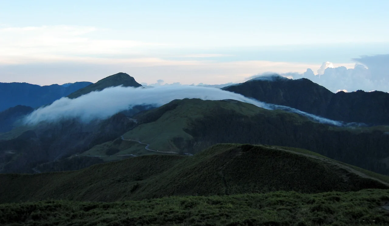
Somewhere above 3,000 meters, the subtropical vegetation gives way to alpine grassland, and Taiwan looks like an entirely different country. Mount Hehuan -- known in Chinese as "Joy Mountain" -- rises to 3,416 meters in central Taiwan, straddling the border between Nantou and Hualien counties within the western reaches of Taroko National Park. What makes it remarkable among Taiwan's high peaks is not its height (the east peak at 3,421 meters and north peak at 3,422 meters are both taller) but its accessibility. A wide, paved trail leads to the summit in roughly 90 minutes round trip, making Hehuanshan the rare 3,000-meter peak you can conquer in sneakers. On a clear day, the 360-degree panorama from the top encompasses the full sweep of the Central Mountain Range, one of the most dramatic geological formations in East Asia.
The Highest Road in Taiwan
Highway 14 climbs through some of the most spectacular terrain on the island, connecting the town of Puli through Wushe and Qingjing Farm to the Wuling pass, a saddle between the main peak and east peak of Hehuanshan. At 3,275 meters, Wuling is the highest point in Taiwan accessible by road. The highway is narrow, winding, and considered dangerous -- a reputation earned through hairpin turns, steep drops, and winter conditions that bring something rare to subtropical Taiwan: snow. When it snows on Hehuanshan, the road clogs with locals who have driven hours from the lowlands for the novelty of seeing their breath in the cold. Highway 14 is currently the only available road crossing the Central Mountain Range, connected to the famous Taroko Gorge on its eastern descent. The Central Cross-Island Highway, which once crossed the mountains north of Hehuanshan, was damaged beyond repair during the 1999 Jiji earthquake and remains closed indefinitely.
A Deadly Survey
In March 1913, a Japanese surveyor led an expedition to scale Hehuanshan and map the surrounding terrain. The mountains had other plans. A storm caught the party on the exposed slopes, and 89 Taiwanese members of the team perished -- the deadliest mountaineering disaster in Taiwan's history. Seven months later, in October 1913, another surveyor named Noro returned and completed the work, producing maps that would prove critical for the Japanese military during the Truku War against the indigenous Truku people of the region. The mountain's beauty has always been inseparable from its danger. Weather at these elevations shifts with startling speed, and the same clear skies that draw hikers can give way to whiteout conditions within hours.
The Ghost Ski Lift
Hikers on the east peak trail sometimes notice something unexpected: the rusting remains of a ski lift mechanism, half-hidden in the alpine grass. During Taiwan's martial law period, which lasted from 1949 to 1987, a ski area operated on the mountain's slopes -- but it was reportedly reserved for the island's political and military elite, inaccessible to ordinary citizens. The unreliability of snowfall eventually made the operation impractical, and the lift was abandoned years ago. Its remains are now a curiosity, a relic of an era when Taiwan's mountains served the pleasures of the powerful. A military training area was also built nearby, reinforcing the mountain's dual identity as both natural wonder and instrument of state control.
Dark Skies, Bright Stars
In 2019, Hehuanshan was designated an International Dark Sky Park, a recognition that its elevation, remoteness, and distance from major light sources make it one of the finest stargazing locations in East Asia. At the summit, a weather station sits where the trail ends, but the real draw after dark is overhead. The thin atmosphere at 3,400 meters reveals a density of stars invisible from Taiwan's coastal cities, where light pollution washes out all but the brightest objects. The Milky Way arcs across the sky with a clarity that can stop you mid-step. Hehuanshan offers something increasingly rare in densely populated Asia: genuine darkness. Combined with the ease of access -- you can drive to within an hour's walk of the summit -- it has become one of Taiwan's most popular destinations for astrophotography and naked-eye observation.
From the Air
Coordinates: 24.181°N, 121.281°E, on the border of Nantou and Hualien counties in central Taiwan. The peak is within the western part of Taroko National Park. Highway 14 is visible as a thin line winding up the mountain to Wuling pass (3,275 m). The summit weather station may be visible from lower altitudes. The Central Mountain Range extends north and south from the peak. Nearest airports: Taichung (RCMQ) approximately 70 km west, Hualien (RCYU) approximately 50 km east. Extreme caution advised due to mountain weather and high terrain -- peaks exceed 3,400 m in this area.
Nearby Stories
- 1951 East Rift Valley Earthquakes 6.1 km away
- 2021 Hualien Train Derailment 7.1 km away
- Beidou, Changhua 7.1 km away
- Changhua Roundhouse 11 km away
- Mount Dabajian 15 km away
- Nanao (Taiwan) 17 km away
- Formosan Aboriginal Culture Village 17 km away
- Taiwan Strait 79 km away