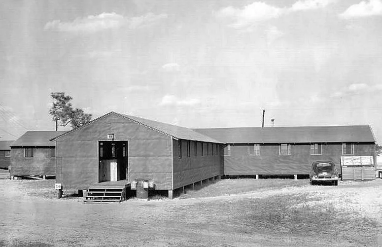

Laurinburg-Maxton Army Air Base
The glider had no engine. Eighty-three feet of wingspan, 4,000 pounds empty, plywood and steel tubing and doped canvas — and inside it, thirteen fully equipped soldiers, or a jeep with a four-man crew, or a 75mm howitzer with its ammunition. To fly it into combat, a C-47 Dakota tow plane connected by a 350-foot rope would haul the loaded glider over enemy territory, the pilot would release the rope, and then he would land in a field that may or may not exist, may or may not be cratered, may or may not have Germans waiting at the treeline. Then, because there was no taking off again, the pilot grabbed his M1 carbine and fought as infantry until the position was either taken or retaken. Between June 1944 and October 1945, more glider pilots were trained at Laurinburg-Maxton, North Carolina, than at any other base in the world.
A Town Asked for an Airfield
It began as a hopeful local petition. In December 1941, just after Pearl Harbor, citizens of Laurinburg and Maxton learned the federal government wanted to put a training airfield somewhere in the area. Local governments wrote to Washington begging for it. The deal that emerged in May 1942 was unusual: four local townships would buy 583 acres and lease the land to the War Department for the duration; afterward the property would revert to civilian use as a public airport. Construction was authorized April 20, 1942. Within six months — a pace impossible to imagine today — three 6,500-foot runways were laid out in a triangle, twenty miles of paved roads ran through the support station, water wells were sunk, a railroad spur built, and barracks, hangars, dining halls, a hospital, and chapel rose from longleaf pine country at a cost of more than ten million dollars. The base was designed for ten thousand men.
What They Trained For
Gliders are not romantic in 1944. They are expendable. The Waco CG-4A could fly a single mission and was often left in the field afterward, too damaged or too far from a runway to recover. The pilots were expendable in a related sense — they had no second chance, no go-around, no engine to power out of a bad approach. The course at Laurinburg-Maxton was eight weeks. Pilots learned to fly behind the C-47 tow plane, to release at altitude, to descend in dead silence to a field they had seen only on aerial photographs, and to land hard enough to stop before hitting whatever lay at the field's edge. They also trained to fight: M1 carbine, bazooka, sub-machine guns, mortars, hand grenades, tank-hunting, jungle reconnaissance, the study of Japanese small-unit tactics. By the end of the course they were dual-purpose: aircrew until touchdown, infantry from touchdown onward.
Snatch Pick-up at Lee's Mill
One technique trained here became famous. A glider on the ground — perhaps loaded with wounded soldiers — could be retrieved by a C-47 flying low overhead. The C-47 trailed a grappling hook on a long line; the line caught a loop strung between two upright poles in front of the glider; in an instant of violent acceleration the glider was airborne again. They practiced it at the airfield. They also practiced water ditchings — landings in Lee's Mill Pond, a millpond near the base where pilots learned to put a glider down in water and get the wounded out before the airframe sank. The first glider pilot training class began on June 2, 1944 — four days before the Normandy invasion. By war's end, more than forty Army and Air Force units had cycled through, including elements of the 82nd and 101st Airborne Divisions. Generals Eisenhower and Marshall both came to watch.
Quick Death, Quick Closing
By April 1945, the base population was around ten thousand. By the end of September — five weeks after Japan's surrender — it had fallen to 914. By October 30, 1945, the base was closed. The hangars stayed. The runways stayed. The pursuit-driving track that North Carolina Highway Patrol cadets used from the 1960s through the early 1990s ran on the old taxiways. Lee's Mill Pond is still there. The base chapel stands today as Skyway Baptist Church. The base hospital became Scotland Memorial Hospital before moving to a newer facility six miles southeast. The airfield is now Laurinburg-Maxton Airport (ICAO: KMEB) — still used occasionally by Fort Bragg airborne units doing exactly what their predecessors did here eighty years ago, training to drop into places they cannot otherwise reach.
What the Maps Don't Say
There is a tension in the postwar memory of the base that the official history acknowledges only briefly. The county is Lumbee country. The relationship between Lumbee people and the North Carolina Highway Patrol — the agency that used the airfield for pursuit-driving practice for thirty years — was poisoned by events including the 1958 Battle of Hayes Pond (when armed Lumbees broke up a Ku Klux Klan rally near Maxton) and a series of incidents in the 1960s and 1970s. Patrol cars parked at the airfield were repeatedly vandalized over the decades. The official base history mentions this in a single sentence and moves on. The full story belongs to the Lumbee histories of Robeson and Scotland counties, told in other places by other voices. What Laurinburg-Maxton remains is many things at once: the largest glider school in the world, a chapel that became a Baptist church, a runway where C-47s once practiced snatch pick-ups, and a place where local memory runs deeper than any single official narrative.
From the Air
Laurinburg-Maxton Airport (ICAO: KMEB; field elevation: 217 feet MSL) sits at 34.79°N, 79.37°W, about 6 miles east-northeast of Laurinburg, North Carolina, near the Scotland-Robeson county line. From altitude the original WWII layout is unmistakable: three 6,500-foot runways in a triangle pattern, with the support station to the east. Today the field is used for general aviation, occasional Fort Bragg airborne training, and as a glider hub. Nearby airports: Fayetteville Regional (KFAY) 40 miles east, Pope Field (KPOB) 35 miles northeast at Fort Bragg, Florence Regional (KFLO) 45 miles southwest. Look for the distinctive triangle runway pattern, Lee's Mill Pond just north of the field, and the surrounding sandy soils of the Sandhills region.
Nearby Stories
- Cheraw, South Carolina 8.6 km away
- Delta Force 17 km away
- Darlington County, South Carolina 20 km away
- Columbus County, North Carolina 23 km away
- Battle of Colson's Mill 32 km away
- Battle of Averasborough 33 km away
- 1958 Mars Bluff B-47 Nuclear Weapon Loss Incident 45 km away
- Sampson County, North Carolina 46 km away