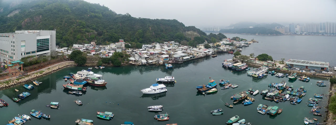

Lei Yue Mun
The name translates as Carp Gate, and at its narrowest, the channel is barely wide enough to feel like a gate at all — just a slim corridor of grey-green water where the South China Sea squeezes between Kowloon and Hong Kong Island. Lei Yue Mun has been the eastern entrance to Victoria Harbour since the first trading ships felt their way in from the open ocean, and it has held two entirely different lives on its opposite banks ever since: fortifications on one side, fishing villages on the other.
Two Shores, Two Worlds
Stand at the water's edge in Sam Ka Tsuen and Victoria Harbour opens before you, wide and silver in the haze. Behind you, a tangle of low buildings clings to the hillside — the fishing village of Lei Yue Mun, which spreads across four sub-villages: Ma Pui Tsuen, Ma San Tsuen, Ma Wan Tsuen, and Sam Ka Tsuen. These communities grew from the sea outward, built by families who pulled their living from the same waters the colony's merchants and warships used. On the opposite shore, barely 500 meters away, the Hong Kong Island side kept a different face: fortifications, barracks, the Lei Yue Mun Fort that once commanded the harbour mouth. The fort is now the Hong Kong Museum of Coastal Defence; the barracks became the Lei Yue Mun Park and Holiday Village. The guns are gone. The fishing boats remain.
Carp Gate and Its Names
British cartographers and sailors spent years wrestling with the Cantonese pronunciation, leaving a trail of creative spellings: Ly-ce-moon Pass, Ly-ee-moon Pass, Lymoon, Lye Moon Passage. None of them captured what the name actually meant — Lei Yue Mun, meaning Carp Gate, pronounced Lei5 yu4 mun4 in Cantonese. The carp was a fish of good fortune in Chinese tradition, and the gate was the passage that gave ships access to one of Asia's great commercial harbours. That combination of luck and commerce shaped everything that followed on the Kowloon side. A Tin Hau temple in Ma Wan Tsuen, built in 1753 and completely reconstructed in 1953, has watched over the fishing community for generations — dedicated to the goddess of the sea, practical patron of people who depended on it.
Tanks of Live Seafood Along the Path
The walk from the ferry pier through Sam Ka Tsuen has a particular quality that cannot be replicated in a restaurant: you choose your dinner while it is still alive. The seafood market and restaurants that have made Lei Yue Mun famous are built right into the village lanes, with tanks of live fish, lobster, crab, and shellfish lined up outside modest storefronts. Visitors carry their purchases a few steps to nearby restaurants, hand them over, and wait for the kitchen to do the rest. The ferry from Sai Wan Ho on Hong Kong Island costs HK$9 per adult — a crossing that takes minutes but lands you in a place that feels genuinely separate from the city on the other shore. The short distance is part of the appeal: the harbour crossing is real enough to feel like a journey.
Layers of History in Stone
Before the seafood trade, before the fishing villages expanded, Lei Yue Mun was quarried. The Old Quarry Site Structures on the Kowloon side are listed as Grade III historic buildings — remnants of the stone extraction that supplied Hong Kong's building boom during the colonial period. Loading ramps and cut faces in the hillside record an earlier economy, one based on what the land could give rather than what the sea could. A lighthouse still marks the channel. A Wish Tree stands nearby. These things persist alongside the MTR station at Yau Tong, the shopping malls, the public housing estates — layers of different centuries stacked into a few square kilometers of reclaimed and natural ground.
The View from the Water
The ferry crossing between Sam Ka Tsuen and Sai Wan Ho is one of the shortest in Hong Kong and one of the most instructive. From the middle of the channel, the city arranges itself in a way that no map conveys: Kowloon's dense grid pressing down to the water on one side, Hong Kong Island's peak rising steeply behind the waterfront on the other, and the channel between them busy with container ships, pleasure craft, and the occasional squid-fishing boat heading out as the light falls. Lei Yue Mun is where the harbour's eastern gate still stands — quieter now than in the era of warships, but no less essential to understanding how this city relates to the sea that made it.
From the Air
Lei Yue Mun sits at 22.2847°N, 114.238°E, marking the eastern entrance of Victoria Harbour between Kowloon and Hong Kong Island. At 2,000–3,000 feet, the narrow channel is visible as a distinct gap in the coastline, with the Sam Ka Tsuen Typhoon Shelter identifiable as a sheltered bay on the Kowloon side. The nearest major airport is Hong Kong International Airport (VHHH), approximately 35 km to the west on Lantau Island. The Sai Wan Ho waterfront on the Hong Kong Island side provides a clear visual reference point. In clear conditions, the channel is one of the sharpest navigation features in the harbour approach.
Nearby Stories
- Lok Ma Chau Loop 2.3 km away
- Portas do Cerco 2.3 km away
- Kweilin Incident 17 km away
- Wanshan Archipelago Campaign 34 km away
- Nanxiong Formation 115 km away
- Battle of Nanpeng Island 148 km away
- Heyuan 169 km away
- Cape Maobitou 632 km away