Liemers
The Romans drew their northern frontier across what is now the Liemers, and almost two thousand years later a Dutch household-goods chain drew its catchment area across roughly the same line. The name Liemers, scholars argue, comes from Limes - the Latin word for the border of the Roman Empire, which ran along the Rhine here, with the legions south of the river and Germanic tribes to the north. The frontier moved on. The region kept the name, kept the river, and now keeps something of its old border-zone character: too small to be a province, too distinct to be just another corner of Gelderland, sandwiched between Arnhem and the German line, with a flat-pack furniture warehouse where a fort used to be.
The Island and the Furniture Hub
The Liemers consists, depending on how strictly you count, of four or five municipalities: Duiven, Westervoort, Zevenaar, Rijnwaarden (which has since merged into Zevenaar), and Montferland - the last of which is not officially Liemers but is generally treated as such by people who actually live there. Duiven is the regional shopping hub. Almost nobody comes to Duiven for the cityscape. They come for the Makro, the IKEA, the MediaMarkt, and the Intratuin garden center, the kind of cluster that gathers along Dutch motorways at predictable intervals. Rijnwaarden, before it merged with Zevenaar, was sometimes called Het Gelders Eiland - the Guelders Island - because rivers surround it on every side: the Rhine, the Old Rhine, and the Pannerdensch Canal. The land in the middle is mostly agricultural and quietly beautiful, and Germans cross the border to spend weekends on it.
Montferland's Hill
Compared to the rest of the Netherlands, Montferland is hilly - which in Dutch terms means that it has slopes you actually notice while pedaling. The municipality was created on January 1, 2005, by merging Bergh and Didam. Bergh, probably named for its castle, was the seat of the counts of Bergh and has always looked toward Doetinchem for cultural orbit. Didam was older - much older. Where the town now stands was a Germanic settlement in Roman times, and the loose Roman coins still turning up in fields nearby, including a fourth-century coin hoard, mark out a place that was lived in continuously long before the modern Netherlands existed. The Didam Castle - Berghvrede - stood from around 1100 until a fire in 1503; its tower lingered until 1606, and the moat was filled only at the end of the nineteenth century. In 2012 archaeologists found the castle again under modern Didam. Bergh's forested terrain has become a favorite of off-road cyclists, hikers, and horseback riders who appreciate gradients.
The Cyclone of 1925
On August 10, 1925, a cyclone - in Dutch the Stormramp van Borculo - tore through the eastern Netherlands and destroyed most of the historic center of Didam. The same storm leveled large parts of Borculo, gives the disaster its Dutch name, and remains one of the most damaging tornadic events in the country's modern history. Whatever medieval streetscape Didam had preserved into the early twentieth century went down that afternoon. The settlement rebuilt, in the practical Dutch way, but the architectural layer that the cyclone took out was never put back. It is a small reminder that even a country famous for managing water has been shaped, in places, by weather it could not predict.
Westervoort's Bridge
Westervoort, on the west edge of the Liemers, is mentioned in a 726 document, which makes it the oldest known settlement in the region. It belonged to the Bergh lands until 1735, when the city of Arnhem bought it. For most of its history, getting to or from Westervoort meant taking a ferry across the IJssel - a single veer was the only crossing until 1855, when the first railway bridge was built. A road bridge followed in 1901, and on May 10, 1940, that road bridge was destroyed in the opening hours of the German invasion of the Netherlands. The demolition counts as the first act of the Second World War on Dutch soil. Westervoort itself came through the war without major damage and slowly suburbanized into Arnhem's eastern edge during the 1980s, the way small towns on the outskirts of bigger ones almost always do.
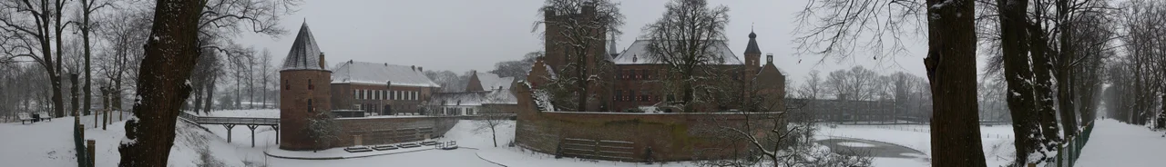
The Achterhoek's Front Porch
Geographically and culturally, the Liemers sits in a hinge. The west of the region connects easily to Arnhem and Nijmegen, the two big Gelderland cities. The north opens onto the Achterhoek, the deeply rural eastern Netherlands - Doesburg with its medieval walls, Doetinchem with its three windmills and one football team, Bronckhorst with its improbable density of castles, Oost Gelre with the Zwarte Cross festival. The east opens onto Germany: Bocholt, Emmerich am Rhein, and Kleve are all a short hop across the border, and Duisburg is barely an hour away. Huis Bergh in 's-Heerenberg is the standout sight: one of the largest castles in the Netherlands, with a moat, a collection of late medieval Italian paintings, and the long quiet feeling of a fortified country house that has been lived in continuously for centuries. It is, in many ways, what the Liemers itself is: small, layered, watched by rivers, easy to overlook, and rewarding when you don't.
From the Air
The Liemers region lies at approximately 51.94 N, 6.14 E in Gelderland province, the eastern Netherlands, bounded by the Rhine, IJssel, and Oude IJssel rivers and by the German border. Arnhem is immediately to the west; Doetinchem just to the northeast. The nearest commercial airports are Niederrhein/Weeze (EDLV) 35 km southeast in Germany and Dusseldorf (EDDL) 90 km south. Recommended viewing altitude 5,000-8,000 ft to take in the full sweep: the Rhine's split at the Pannerdensch Canal, the Gelderse Poort wetland where the Rhine enters the Netherlands, the hilly Montferland forest, and Huis Bergh's moated bulk at 's-Heerenberg.
Nearby Stories
- Winterswijk 3.6 km away
- St Nicholas Church, Deventer 5.1 km away
- Putten 5.8 km away
- Weeze 6.6 km away
- Twickel Castle 7 km away
- Assault on Nijmegen 8.4 km away
- Sint-Oedenrode 17 km away
- Landschaftspark Duisburg-Nord 23 km away