.jpg)
Linhares
The town was founded on August 22, 1800, by Europeans pushing their way into the Doce River country. Nine years later, the Botocudo people - whose land the settlers had occupied - destroyed the town in a war that left the forest to grow back over what little the founders had built. Linhares was refounded and slowly rebuilt. Two centuries later it is the largest municipality by area in the entire state of Espírito Santo, sprawling across 9,501 square kilometers - larger than some small countries - and holding 69 freshwater lakes, kilometers of beach, and some of the last large tracts of Atlantic Forest anywhere in Brazil.
A Landscape of Sixty-Nine Lakes
Linhares is a country of water. The town sits on the Doce River amid a scattering of 69 freshwater lagoons, some of them vast. The Juparanã Lagoon, 26 kilometers long and up to 5.5 kilometers wide, is the second-largest in water volume in all of Brazil. Others - Japaranã-Mirim, Palmas, Durão, Palminhas, Aguiá, Monsarás - fill the flat coastal plain in patterns that read, from the air, like ponds left behind by a river that changed its mind many times. The landscape is so remarkably level that rain accumulates into lakes rather than running to the sea. Freshwater surrounds freshwater, threaded together by marshes and low forest. Local fishermen know each lagoon by its depth and its fish.
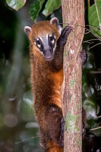
The Last Atlantic Forest
Linhares is home to one of the largest remnants of Atlantic Forest left in Brazil. The Sooretama Biological Reserve covers 27,858 hectares, created in 1982 when two older reserves were merged into one strictly protected unit. The Comboios Biological Reserve adds 785 hectares of fully protected coast. The Goytacazes National Forest, created in 2002, covers another 1,424 hectares. Most remarkable of all, the Vale Natural Reserve - owned by the mining company Vale - is the largest private Atlantic Forest reserve in the country. It is the only place in the world where a rare and endangered tree called Buchenavia pabstii is still found. Less than ten percent of the original Atlantic Forest now remains in Brazil, and a substantial fraction of what survives is in Linhares.
The Botocudo and What Came After
Before the Europeans arrived, the Doce River country was Botocudo land. The Botocudo had resisted Portuguese intrusion for centuries, and when settlers established a town here in 1800, the war was short. In 1809 the Botocudo destroyed the settlement, an act that was both military and in some sense a refusal to be colonized. The town was refounded, and the colonial grind continued. In 1860 Emperor Dom Pedro II himself visited the area, stepping briefly onto an island in one of the lagoons. That island is still called Ilha do Imperador - Emperor's Island - a name that has outlasted the empire itself. The municipality was named in honor of Rodrigo de Souza Coutinho, Count of Linhares, a Portuguese minister who helped shape Brazilian government in the early 19th century, but the Count never set foot here.
The Turtles and the Surf
The Linhares coastline is still wild. Three beach communities - Pontal do Ipiranga, Povoação, and Regência - draw visitors for the surf and the deep-sea fishing. Regência, in particular, has become a fixture on the Brazilian surf map for its river-mouth waves where the Doce meets the Atlantic. Seven kilometers south of Regência, the Comboios Biological Reserve contains the main unit of the Projeto TAMAR, Brazil's sea turtle conservation program. TAMAR has been working this coast since the 1980s, marking nests, protecting hatchlings, and teaching coastal communities that the turtles are worth more alive than as the food-source they had long been. Sixty kilometers east of the town proper is Barra Seca, an officially designated nudist beach - Brazil has only a few of these, and this is among the quietest.
Oil, Cattle, and a Count's Name
Linhares became its own municipality in 1945, when it was detached from Colatina. Today, the economy runs on commerce, agriculture, cattle, and offshore oil - petroleum reserves not far off this coast form part of the broader Espírito Santo-Campos Basin operations. The town is served by Antônio Edson de Azevedo Lima Airport. The population is about 177,000, making it one of the larger municipalities in Espírito Santo despite the vast amount of its territory that remains protected forest or freshwater lake. Walk Regência's beach at dawn and you can see almost the entire arc of what Linhares is: an empty strand, the river meeting the sea, an egret in the shallows, and beyond the headlands the faint outlines of the forest that has survived two centuries of clearing to be here still.
From the Air
Located at 19.40°S, 40.07°W on the Doce River in northern Espírito Santo, Brazil, 135 km north of Vitória. The municipality covers 9,501 km², the largest in the state. Best viewed from 4,000-6,000 ft AGL to pick out the 69 freshwater lagoons scattered across the coastal plain and the vast dark canopy of the Sooretama Biological Reserve inland. Juparanã Lagoon, the second-largest by water volume in Brazil, is a major visual landmark. Nearest commercial airports are Antônio Edson de Azevedo Lima Airport (SNLN) in town and Eurico de Aguiar Salles Airport (SBVT) in Vitória. The coast here includes major sea turtle nesting beaches.
Nearby Stories
- São Mateus, Espírito Santo 50 km away
- Serra, Espírito Santo 65 km away
- Pedra Azul State Park 102 km away
- Mutum, Minas Gerais 114 km away
- Governador Valadares, Minas Gerais 163 km away
- Caraíva 263 km away
- Central Atlantic Forest Ecological Corridor 296 km away
- Roncador Field 564 km away