Serra, Espírito Santo
The state of Espírito Santo has a strange demographic fact embedded in its geography. The capital, Vitória, sits on an island in the harbor, hemmed in by water and unable to expand. The city immediately north of it, Serra, has no such constraint, and as a result Serra has grown larger than the capital it borders. The 2022 census counted 520,653 residents in Serra, making it the most populous municipality in the state. The name comes from a single mountain - Mestre Álvaro - that juts out of the surrounding coastal lowlands and looked enough like a mountain range to the early Portuguese settlers that they called the place serra, the word for range. The mountain is alone. The city is not.
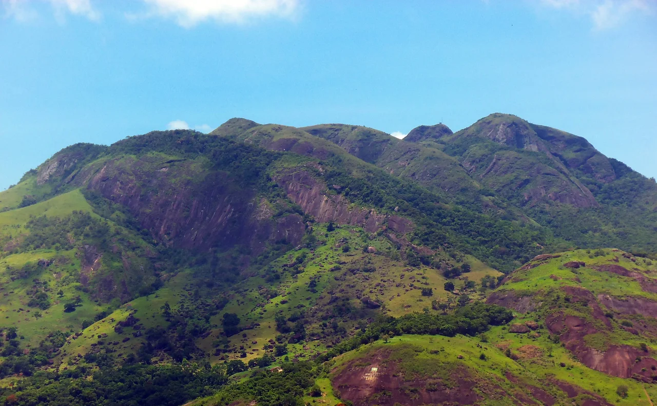
One Mountain, One Name
Mestre Álvaro stands north of the municipal seat of Serra, rising in isolation from the flat coastal plain that surrounds the Vitória metropolitan area. The Portuguese settlers who moved into this region in the sixteenth century had a naming convention for geographic features: anything that rose visibly from the lowland and suggested a line of peaks was a serra. Mestre Álvaro, strictly speaking, is a single mountain rather than a chain, but its mass and its profile were striking enough that the surrounding territory took the name anyway. The colonial settlement at its base inherited the name. The municipality, when it was formalized, inherited the name. Now the fifth-largest city by population in the Southeast Region of Brazil - ahead of Vitória, ahead of many better-known state capitals - carries the name of a single hill whose actual visual prominence is what locals take for granted and visitors tend to notice.
The City That Outgrew Its Capital
Serra sits on the mainland north of Vitória's island. When the Greater Vitória metropolitan area began its rapid industrial expansion in the 1960s and 70s, anchored by the Tubarão steelworks and the port complex that handles iron ore exports from the Minas Gerais mines, the working-class neighborhoods expanded where there was room to build. That room was Serra. Districts like Carapina, Jardim Limoeiro, and the long list of Laranjeiras subdivisions filled with families moving for industrial employment. The current municipality has five distritos - Serra-Capital, Carapina, Calogi, Nova Almeida, and Queimado - divided into 118 bairros. The list of neighborhoods reads like a directory of postwar Brazilian urbanism: André Carloni, Bicanga, Feu Rosa, Hélio Ferraz, Manoel Plaza, Novo Porto Canoa, São Diogo I, II, and III, the numbered Serra Douradas and Taquaras and São Marcoses. Each was built as a planned subdivision in a particular decade. Together they hold more residents than the capital across the bay.
The First Woman in Brazilian Politics
The Serra Historical Museum opened in 2007 in a mansion that once belonged to the family of Judith Leão Castello Ribeiro - who holds the distinction of being the first woman elected as a representative in Brazil, elected to the Espírito Santo state legislature in 1934. The museum's collection includes documents, furniture, tobacco pipes, binoculars, mirrors, and works of art associated with the history of the municipality and its notable residents. The Casa de Congo, also in Serra, was inaugurated in 2000 by the state Secretariat of Culture to bring together the collection and memory of Congo music and dance traditions in Espírito Santo - a cultural form with deep Afro-Brazilian roots, centered on specific rhythms, costumes, and ritual observances that connect the state to the broader African diaspora across the Americas. The municipality operates two municipal libraries, the Municipal Council library, a mobile library, and two community-based libraries that operate independently of both state government and private sector funding.
The Surfers at Jacaraípe
Twenty kilometers north of Vitória along the coast sits Jacaraípe, one of the most important urban zones within the municipality of Serra. The beach there has become the regional focal point for surfing championships, thanks to the consistent swell that reaches this stretch of Atlantic coast. Weekend traffic from Vitória fills the beach and the restaurants behind it. Smaller fishing villages like Manguinhos remain within day-trip distance and draw visitors looking for something less developed. The Costa das Algas Environmental Protection Area, established in 2010, covers 112,545 hectares of coastline and offshore waters, protecting the algae beds - the costa das algas, literally, the coast of algae - that sustain the fishery and the reef ecosystem. This stretch of Espírito Santo's Atlantic coast is less famous than the beaches of Rio de Janeiro to the south or Bahia to the north, but the surfers who compete at Jacaraípe have made a case that the waves here deserve attention in their own right.
Industrial Base, Metropolitan Periphery
The economy of Serra runs on steel and ports. The CST-Arcelor Mittal Tubarão plant on the Vitória side of the bay sends its iron ore exports out through the Ponta de Tubarão terminal, which processes some of the largest vessels in the world's iron ore fleet. The logistics infrastructure that supports those exports - warehouses, trucking companies, chemical industries that use steel and port byproducts - is concentrated in Serra. This industrial base, combined with the cheaper housing on the mainland, is why the municipality has grown so fast. It is also why Serra carries some of the same urban challenges common to Brazilian metropolitan peripheries: rapid population growth outpacing infrastructure, uneven public services between the older central districts and the newer subdivisions, traffic pressure on the bridges connecting to Vitória island. The city is growing. The mountain that gave it its name is unchanged. Most residents drive past Mestre Álvaro every day on their way to work, and the isolated peak that the Portuguese settlers once mistook for a range still stands where it always has.
From the Air
Serra is located at 20.13 degrees south, 40.31 degrees west, immediately north of Vitória on the Espírito Santo coast. The municipality wraps around the isolated peak of Mestre Álvaro mountain, which reaches about 833 m elevation and stands out prominently from the surrounding coastal lowlands. Recommended viewing altitude 3,000-5,000 ft AGL. The urban area spreads from the coast inland, with the Tubarão port complex and steel industry visible just across the bay on the Vitória side. Jacaraípe beach is on the coast about 20 km north of downtown Vitória. Nearest airport is Vitória/Eurico de Aguiar Salles (SBVT) about 15 km south. BR-101 runs north-south through the municipality.
Nearby Stories
- Pedra Azul State Park 25 km away
- Guarapari 40 km away
- Linhares 55 km away
- Mutum, Minas Gerais 69 km away
- Feliciano Miguel Abdala Private Natural Heritage Reserve 118 km away
- Itaúnas 160 km away
- Petrobras 36 187 km away
- Caraíva 374 km away