Mutum, Minas Gerais
At the top of Pedra Pirraça, inside a small masonry church that has been destroyed by wind and rebuilt twice, a spring runs. It is considered holy. It never dries up. The carpenter Teófilo Belmiro built the original wooden chapel here, dedicated to Our Lady of Montserrat, and when wind took it down, the community rebuilt. When time took it down again, they rebuilt once more in stone. The hill it stands on marks something geologically interesting - the place where the lowlands of the Rio Doce valley give way to the foothills leading up to the Serra do Caparaó. This is the municipality of Mutum, 1,256 square kilometers of collision between two landscapes, home to 27,635 people who take their water from a spring that refuses to quit.
Where Two Landscapes Meet
Mutum occupies a specific geological moment - the transition between the flat Rio Doce basin and the mountainous Serra do Caparaó region that peaks at Brazil's third-highest summit. The valley side holds lagoons and seasonal wetlands. The mountain side holds ridges that break 1,000 meters above sea level in districts like Roseiral, Humaitá, and Imbiruçu. The municipal seat itself sits at 240 meters, positioned on the low side of the divide, at 19°49' south and 41°26' west. Three rivers wind through - the São Manoel, the Mutum itself, and the José Pedro - watering coffee plantations and dairy pastures. The drive in from Lajinha on MG-108 shows the full topographic story in a few hours: river valley, rolling cerrado, the first granite outcrops, the rising peaks beyond.
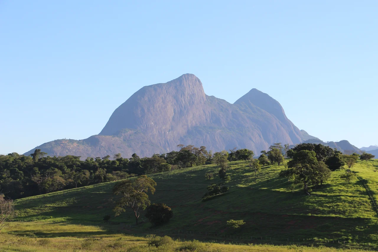
The Stones with Names
Three rocks define the local imagination. Pedra do Gaspar. Pedra do Facão, the knife. And especially Pedra Invejada - the Envied Rock - considered one of the most beautiful landscapes in the interior of Minas Gerais. A waterfall tumbles off the São Manoel River flanks nearby. The rocks have been climbing destinations for locals for generations, never reaching the scale of the more famous national park walls but drawing a steady trickle of hikers and rappellers who know where to look. Whoever named Pedra Invejada understood something about how rural beauty works: the rocks are not envied by strangers, who have mostly never heard of them. They are envied by the neighboring towns that wish their own hills carried names this good.
Coffee and the Mist That Sells It
The mountainous districts of Roseiral, Humaitá, and Imbiruçu specialize in coffee. The altitudes exceed 1,000 meters. The mornings bring fog that wraps around the ridges and burns off slowly, giving the beans the cool nights and mild days they need. In June the fog sits deep in the valleys while the sun catches the peaks first, turning the horizon gold. Brazilian coffee country is full of these scenes, but specialty buyers in São Paulo and abroad have increasingly learned that altitude and specific microclimate matter more than volume - and Mutum's geography gives it a small but real claim on quality. The terra roxa soils, rich in iron and fertile enough to have fed four centuries of Atlantic Forest before it was cut, still support sugarcane, corn, rice, and beans alongside the coffee.
Dairy, Rodeo, Identity
Beyond coffee, Mutum runs on milk and cattle. Laticínios Porto Alegre, Mutumilk, Laticínios Lito, and Laticínios São Roque - four dairy factories in one interior municipality give a sense of the scale of the operation. Every July, the town hosts ExpoMutum - the Exposição Agropecuária - an agricultural fair with rodeos, food stalls, amusement parks, and a traditional bingo that pulls in visitors from across the region. It is the kind of annual event that small inland cities depend on to mark the calendar and fuel the local economy. For a few days the population of the center doubles. For the rest of the year, the town is quiet, the dairy trucks move at dawn, and the rodeo arena sits empty between seasons.
The Eucalyptus Question
The predominant vegetation here is Atlantic Forest, or was - peroba, cedar, jacaranda, heart of palm, Brazilwood, yellow ipê. The tallest trees still reach 25 to 30 meters, vines and epiphytes threading through the canopy. But eucalyptus plantations have been advancing, displacing native forest, pushing out traditional cattle farming and smallholder coffee in favor of pulpwood monoculture. The Wikipedia article on Mutum puts it bluntly: the municipality is increasingly invaded by eucalyptus. This is the quiet argument of rural Minas Gerais, the one that gets fought in land-use meetings and at kitchen tables. Mutum has not decided how it will end. The holy spring at the top of Pedra Pirraça, meanwhile, keeps flowing regardless of what the humans below settle on.
From the Air
19.80°S, 41.44°W. Mutum lies in eastern Minas Gerais at the transition between the Rio Doce valley and the Serra do Caparaó foothills, with the municipal seat at 240 meters but ridges to the east exceeding 1,000 meters. Recommended viewing altitude 3,500-5,000 m AGL to see both the valley floor and the rising mountain wall. Nearest airports: SBIP (Ipatinga) 120 km west, SNVC (Valença, in Rio de Janeiro state) 350 km south. Morning fog in the mountain districts is seasonal; prefer midday flights after lifting.
Nearby Stories
- Serra, Espírito Santo 50 km away
- Pedra Azul State Park 51 km away
- Vila Império 71 km away
- Rio Doce State Park 75 km away
- Vitória School Attack 76 km away
- Linhares 76 km away
- Governador Valadares, Minas Gerais 100 km away
- Robert Quayle (1814 ship) 109 km away