Long Island, Madang Province
The islanders called it the Time of Darkness. Sometime in the late 17th or early 18th century, the volcano at the heart of Long Island tore itself apart, and the sun went out. Ash blotted the sky as far away as the Rai Coast and Astrolabe Bay, more than a hundred miles across the water, where oral traditions still describe the day the world turned gray. The eruption erased virtually all life on the island itself. Nearly every plant, every insect, every bird - gone. Then, over the centuries that followed, life crept back. Scientists who visit today are watching that return in real time.
An Island Starts Over
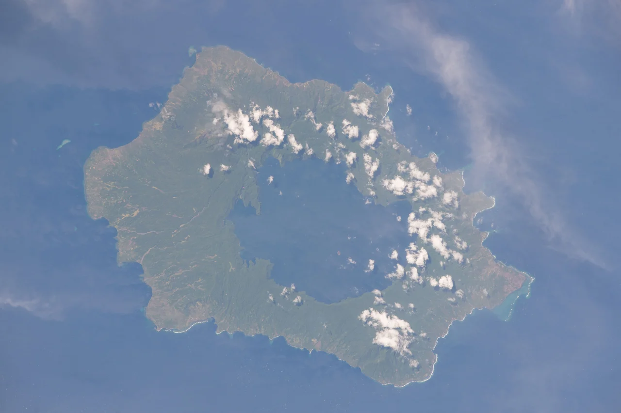
Long Island sits 55 kilometers north of the New Guinea mainland, separated by the Vitiaz Strait. Two stratovolcanoes rise from its body - Mount Reaumur and Cerisy Peak - the collapsed summits of a much larger complex that has exploded at least three times in the past 16,000 years. The 1660 eruption was the big one. Pyroclastic flows and ashfall estimated at 11 cubic kilometers, possibly as much as 30 according to the Global Volcanism Program, made it comparable to or larger than the 1991 eruption of Mount Pinatubo in the Philippines. What remained when the ash settled was a caldera roughly six miles across, now filled by one of the most peculiar lakes in the Pacific: Lake Wisdom, named for Brigadier General Evan Wisdom, the Australian administrator of Papua New Guinea from 1921 to 1933.
A Lake Inside a Lake
Lake Wisdom plunges 360 meters into the caldera floor, and yet even in its deepest reaches, there is oxygen. Researchers have found chironomid larvae and mollusks living at the very bottom, in water where, by every usual rule of tropical crater lakes, nothing should survive. The surface holds steady at 28 degrees Celsius. Sunlight penetrates unevenly, depending on rainfall and on what the volcano is doing that week. Because there is a volcano. Inside the lake, poking up from the water, sits Motmot Island - a new cone that rose in eruptions during 1953, 1954, and 1968, and last spoke in 1993. An island on a lake in a caldera on an island. Papua New Guinea does not do understatement when it comes to geology.
Recolonization
Scientists call this kind of landscape a natural laboratory. When nearly everything dies at once, and then a known amount of time passes, you get to watch the sequence of return. On Long Island the pioneers were plants that could float or fly their seeds across the strait - *Barringtonia asiatica*, with its big buoyant fruits, became one of the most common trees here, precisely because ocean currents could deliver it. Insects, birds, and bats followed. So did the people. According to the oral tradition of the islanders, Long Island was inhabited before the 1660 eruption, and the ancestors read the volcano's warnings well enough to flee to surrounding islands before the mountain blew. Their descendants came back. Today the villages of Malala, Bok, Poin Kiau, Kaut, and Matapun sit along the coast, their houses built in the vernacular style - timber frames, thatched roofs, everything shaped by what the forest provides. Near Bok someone long ago carved a human figure from stone. Nobody knows how old it is.
Charts, Cargo, and Radar
In 1643 the Dutch navigator Abel Tasman sailed past and sketched Long Island onto his charts as part of the New Guinea mainland - an understandable mistake, given the scale of the place and the cloud cover over the strait. Later European visitors filed their own reports. In 1897, a German colonial journal recorded one version of the islanders' creation story, a foundation myth that anthropologists would later connect to the broader tradition of cargo cult belief across Melanesia. During World War II the island's quiet geography turned strategic. The Imperial Japanese forces used Long Island as a barge staging area for operations along the north coast of New Guinea. On December 26, 1943, as Marines hit the beaches 160 miles east at Cape Gloucester, D Company of the 592nd Engineer Boat and Shore Regiment landed on Long Island with orders to set up a radar station. The Royal Australian Air Force's No. 338 Radar Station went operational at Matfum Point on April 6, 1944, and watched Japanese aircraft movements until March 1945.
Flying Over Long Island
From the air, the island reads like a geology textbook cross-section. The outer rim is forest and village; the center is lake; the lake holds a cone; the cone still smokes on quiet days. The population is small, scattered in coastal villages accessible mostly by boat. For pilots crossing from Madang to New Britain, Long Island and its neighbor Crown make an unmistakable pair - William Dampier named them both when he sailed through in 1700, and his names stuck. Beneath the thick canopy on the volcano's flanks, forest ecologists are still counting which species have made it back and which have not.
From the Air
Long Island sits at 5.35 S, 147.12 E in the Vitiaz Strait, north of the New Guinea coast. The island is roughly 22 km long with the prominent Lake Wisdom caldera visible from the air. Cruising altitude 8,000-12,000 ft gives a clean view of the caldera and Motmot Island cone within. Nearest airports: Madang (AYMD) on the mainland about 55 nm southwest, Kimbe (AYKI) on New Britain about 170 nm southeast. Expect scattered convective buildups in the afternoon, particularly during the northwest monsoon (December-February).
Nearby Stories
- Landing at Saidor 33 km away
- Dampier Strait (Papua New Guinea) 66 km away
- Markham, Ramu and Finisterre Campaigns 68 km away
- Karkar Island 87 km away
- Battle of Wareo 93 km away
- Naval Base Alexishafen 147 km away
- Vitu Islands 188 km away