Karkar Island
In 1979 an eruption on Karkar Island killed no locals. It killed the two volcanologists who had gone up to study it. Robin Cooke and Elias Ravian are still on the mountain somewhere, their deaths a reminder that this symmetrical green oval in the Bismarck Sea is an active stratovolcano with nested calderas and a habit of killing the people who look at it too closely. Seventy thousand people live on the outer slopes anyway, growing cacao and coconuts in the fine volcanic soil, sending their children to one high school, trusting the road that circles the island and the single hospital run by rotating German Lutherans.
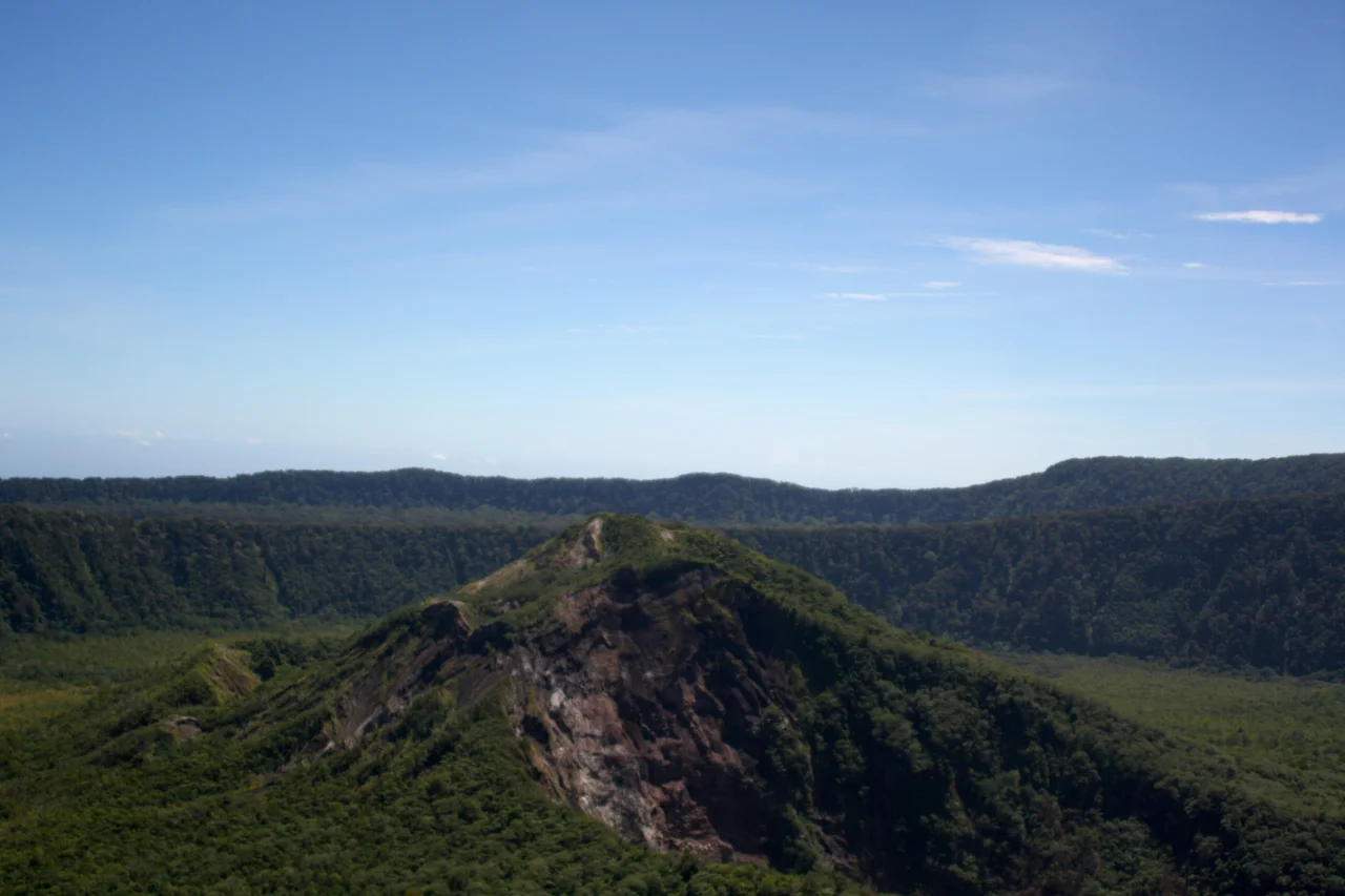
A Nested Caldera
From the air Karkar is an almost perfect oval, twenty-five kilometers long and nineteen wide, set seventy-four kilometers off the New Guinea coast across the Isumrud Strait. The symmetry is a lie. Inside the outer rim, a second caldera nests inside the first. Both were formed by explosive collapse. In the 1974-1975 eruption, lava flows covered nearly 70 percent of the inner caldera's floor, building fresh rock over the old scars. The andesitic lavas weather into exceptionally fertile soil, which is why the island's population is so much denser than its geology would suggest. The earliest recorded European sighting was by the Spanish navigator Iñigo Órtiz de Retes on 10 August 1545, aboard the carrack San Juan during a failed attempt to sail east from Tidore to New Spain. Willem Schouten and Jacob le Maire later called it "High island." Abel Tasman passed by in 1643. William Dampier probably landed in 1699. Then the volcano erupted in 1895, and again in 1974, and 1979, and most recently on 26 February 2013.
Waskia and Takia
The island has two indigenous languages and, remarkably, no serious conflict between them. Waskia is an Austronesian-adjacent Papuan language; Takia is an Oceanic Austronesian language. They evolved in proximity for so long that linguists study them as a case of intense mutual influence. Most islanders speak both, plus Tok Pisin, plus the English taught in schools. The 70,000-strong population is overwhelmingly Christian, split between Lutheran and Catholic congregations that trace back to the German missionary presence of the late 1800s. The single road that loops around the island is the circulatory system: minibuses and trucks run it constantly, moving produce, children, and people who need to reach Karkar Secondary School, the only high school on the island, or Gaubin Hospital on the western coast.
Cacao and Coconut
Karkar's two main exports grow in the same soil, using the same labor, but at different elevations. Coconuts thrive on the lower slopes, where the salt air and the hot sun favor the palms. Cacao grows higher up, where it is cooler and wetter, under the shade of other trees. The plantations are mostly family-owned rather than corporate, a pattern that has held through colonial administration and into independence. The island is also famous across the country for betel nut, mustard plant, and lime, the three ingredients of the chew that reddens mouths throughout coastal Papua New Guinea. The view from the high rim is one of the reasons people visit: on clear mornings you can see across the Bismarck Sea to Madang town, forty-odd miles south, the coast of New Guinea stretching away in both directions.
A Hospital Run By Germans
Gaubin Hospital, known formally as the Edwin and Tabitha Tscharke Memorial Hospital, sits on the western shore of Karkar. It is operated by the Lutheran Health Service and staffed by a rotating group of German doctors who come for tours of six months or a year. The hospital trains community health workers for the surrounding villages, a decentralized model of care that has held together even as the national health system has struggled. This is how Karkar keeps functioning: a hospital funded from abroad, two languages shared between neighbors, a volcano that lets its residents live on it most of the time, and plantations passed down through families who have been reading the soil for generations.
From the Air
Karkar Island lies at approximately 4.63°S, 145.97°E in the Bismarck Sea, 74 km north of the Madang coast across the Isumrud Strait. The volcanic peak rises to 1,839 meters (6,033 ft); maintain clearance accordingly. The symmetrical oval shape makes it a highly recognizable waypoint. There is a small airstrip on the island for light aircraft. The nearest controlled field is Madang Airport (AYMD) to the south. Karkar's volcanic plume has reached 15,000+ feet during eruptions; consult the Volcanic Ash Advisory Center in Darwin for current activity before overflight. Tropical rainforest climate (Af) produces heavy rainfall year-round and frequent low cloud around the summit.
Nearby Stories
- Naval Base Alexishafen 35 km away
- Curt von Hagen 41 km away
- Manam Motu 67 km away
- Territory of New Guinea 72 km away
- Landing on Long Island 74 km away
- Long Island, Madang Province 96 km away
- Sepik 181 km away
- Manus Island 257 km away