Manam Motu
The locals call them avalanche valleys. From above, they are four shallow scars descending from the summit of Manam, an almost symmetrical cone rising out of the Bismarck Sea between Yawar and the Boisa Islands. When the volcano erupts, pyroclastic flows funnel down these valleys at the speed of an avalanche, which is how they got the name, and which is why the entire population of over 9,000 people was evacuated in 2004. Manam is still erupting. Many have returned anyway. On March 8, 2022, the mountain sent a column of ash 15 kilometers into the atmosphere, confirmed by the Volcanic Ash Advisory Center in Darwin.
The Shape of the Hazard
Manam is a basaltic-andesitic stratovolcano, the classic cone shape of the most familiar volcanoes on Earth. The lower flanks are remarkably symmetrical, which is part of what makes the island look so striking from the air or from a ship passing in the Bismarck Sea. But four distinct valleys cut from the summit to the sea, and these are the danger. They focus everything that comes down the mountain: ordinary rainwater during monsoon, ashfall after minor eruptions, and above all pyroclastic flows during major events. The earliest documented eruption was in 1616. A 2005 eruption produced a sulfur dioxide cloud so large it was tracked from orbit by NASA's Aura satellite. On 3 December 1996, pyroclastic flows reached the village of Budua, killing thirteen residents outright.
The 2004 Evacuation
The 2004 eruption began on 24 October and was at first treated as a manageable inconvenience. Then the wind shifted. Ash and volcanic debris began falling on inhabited areas on the leeward side of the island, and the Papua New Guinea government authorized an emergency evacuation. Over 9,000 islanders were moved to the mainland at Bogia. Five people died during the eruption. By 11 December, seismic activity had dropped and the immediate threat was downgraded, but by then the population was already dispersed across temporary camps at Mangem, Asarumba, and Potsdam. The camps became a long-term problem. In March 2007, three people were killed by mudslides on the north of the island itself, and the same month the national government made land available at Andarum, near Bogia, for permanent resettlement of the displaced.
Returning to a Volcano
Despite the danger and despite government advice, people began going home. By 2014, somewhere between 2,000 and 3,000 Manam Islanders had returned to the island, rebuilding houses in villages they had been told not to inhabit. The reasons are familiar anywhere people return to dangerous ground: the land is theirs, the mainland camps have been difficult and sometimes desperate, and the rhythm of life that held extended families together is rooted in specific places that cannot be reproduced elsewhere. The 2022 eruption, which spewed ash 15 kilometers into the atmosphere and was picked up immediately by the Darwin VAAC, did not produce a second mass evacuation. The mountain is still active as of January 2024. So is the decision people keep making to live on it.
Manam Pile
The islanders speak their own language, called Manam Pile, which translates literally as "Manam talk." It is also spoken on the nearby Boisa Islands. Manam Pile belongs to the Oceanic branch of the Austronesian family, a language group that spread across the Pacific on outrigger canoes. Within Papua New Guinea, where more than 800 languages are still spoken, Manam Islanders are known especially for their music. The community has produced several nationally recognized musicians. Between eruptions, the island hums with the ordinary business of tropical coastal life: gardens, fishing, the Lutheran and Catholic churches that split the religious loyalties, the voices of children who have grown up knowing that their playground is also a caldera wall, and that the green symmetrical mountain at the center of their world will, periodically, try to wash them into the sea.
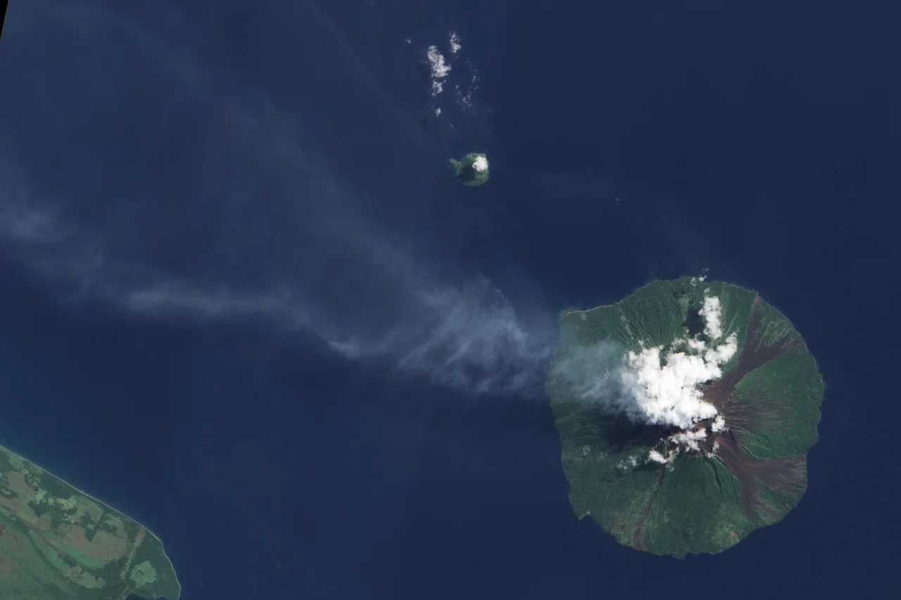
From the Air
Manam Motu is located at approximately 4.08°S, 145.03°E in the Bismarck Sea, about 12 km off the mainland coast of Papua New Guinea's Bogia District. The summit reaches 1,807 meters (5,928 ft); maintain substantial vertical clearance given active ash emissions. The island is roughly circular and 10 km across. The Volcanic Ash Advisory Center in Darwin issues regular advisories for Manam; consult current activity status before overflight. The nearest significant airport is Madang (AYMD) to the southeast. The four "avalanche valleys" radiating from the summit are visible from the air and are the channels for pyroclastic flows during major eruptions.
Nearby Stories
- Sepik 53 km away
- Karkar Island 54 km away
- Territory of New Guinea 67 km away
- Bombing of Wewak 102 km away
- Naval Base Alexishafen 110 km away
- Operation Copper 128 km away
- Highlands Highway 150 km away
- Manus Island 247 km away