Dampier Strait (Papua New Guinea)
In 1700, a British buccaneer-turned-explorer named William Dampier discovered he was wrong about the map. The hydrographers had drawn the easternmost land beyond New Guinea as a continuous coast, an unbroken extension of the same great island. Sailing along that coast aboard the *Roebuck*, Dampier saw an opening. Water where water was not supposed to be. He steered through it, kept looking north, and saw only more water - no land closing the horizon, no trick of the eye. The mass to the east was not New Guinea at all. It was a separate island. He named it New Britain. The strait that proved it is still called Dampier Strait today.
The Pirate Who Drew the Coast
Dampier was an unlikely geographer. A former privateer who had already circumnavigated the globe twice by the time he sailed into these waters - the first person to circumnavigate the world three times - he was both scientist and scoundrel, a meticulous observer of plants, winds, and currents who kept losing ships to mutiny, scurvy, or rot. In his *A Continuation of a Voyage to New Holland*, Chapter 4, he recorded the moment of discovery in sober prose: "Here I found an opening and passage between, with many islands; the largest of which lie on the north side of this passage or strait. The channel is very good." He named the northwest cape of the new land Cape Gloucester and its mountain Mount Gloucester. He named a northern island, crowned with peaks, Crown Isle. He named a long thin island Long Island, because that is what it looked like. The names have lasted three hundred years.
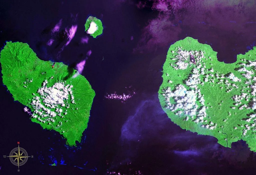
Between Two Seas
The strait links two bodies of water with very different personalities. To the north lies the Bismarck Sea, shallow, warm, fringed with reefs. To the south lies the Solomon Sea, which plunges fast into some of the deepest water in the western Pacific. In between, Dampier Strait runs thirty miles wide between Umboi Island - which Dampier named Sir George Rook's Island after his patron in the Royal Navy - and the northwestern tip of New Britain. Crown Island rises on the western approaches. Long Island sits nearby, smoking from its caldera. Currents push through hard; reefs crowd both sides. Dampier himself nearly grounded on coral when his boat's crew, sounding for anchorage, found "no ground" a mile offshore and then struck a reef of coral rocks. He kept his distance after that.
Colonies and Cartographers
For nearly two centuries after Dampier, the strait remained mostly a line on charts, a navigational note for ships between Australia and the Spice Islands. In 1883 the colony of Queensland tried to annex eastern New Guinea, only to see Britain undo the annexation the following year. Germany moved into the vacuum in 1884, claiming the northern coast of New Guinea eastward to Dampier Strait and the hinterland behind it. The colonizers renamed the New Britannia Archipelago the Bismarck Archipelago - a name it still carries, honoring the Prussian chancellor who presided over Germany's late scramble for empire. That German era lasted thirty years. When the First World War broke out in August 1914, Australian forces sailed north and took German New Guinea in a matter of months. The Treaty of Versailles formalized what the guns had already decided, converting the territory into a League of Nations mandate under Australian administration.
The Straits at War Again
The Second World War turned Dampier Strait into a strategic choke point. On March 8, 1942, two Japanese battalions landed at Lae and Salamaua on the Huon Gulf, immediately west of the strait. With those footholds, Imperial Japan controlled both the Dampier and the neighboring Vitiaz Strait - the gate through which any Allied advance toward New Britain or the Philippines would have to pass. The Allies spent the next twenty months prying the gate back open. In December 1943, American forces landed on New Britain itself, hitting the beaches at Cape Gloucester on December 26. The strait became a highway for landing craft. Destroyers screened convoys through it. Bombers hunted barges within it. On February 12, 1944, General Douglas MacArthur announced that Rooke Island - Umboi, the bigger of the two islands that border the strait - had been occupied without opposition. Company B of the 1st Marines had crossed the Dampier Strait by landing craft and walked ashore on empty beaches; the Japanese garrison had already slipped away.
Flying the Strait
From the cockpit, Dampier Strait still presents itself the way its namesake first saw it: a gap of blue between two great coasts, dotted with islands. Umboi fills much of the view to the west, a wedge of jungle and mountain that is actually a dormant volcano complex. New Britain rises to the east, its shoreline pocked with the scars of a war only three generations gone. Long Island and Crown Island punctuate the northern approaches. Trade winds push the clouds east to west in the morning and the currents do the same below. Dampier called the channel "very good" in 1700, and by the standards of a man who had buried too many shipmates on coral reefs, that was high praise.
From the Air
Dampier Strait runs between Umboi Island and the Cape Gloucester peninsula of New Britain, centered around 5.61 S, 148.20 E. The strait is about 30 nm wide with depths transitioning quickly from the shallow Bismarck Sea (north) to the deep Solomon Sea (south). Cruising altitude 10,000-14,000 ft gives a commanding view. Nearest airports: Hoskins (AYHK) on New Britain about 85 nm east, Madang (AYMD) on the mainland about 110 nm west. Convective buildups common over both land masses in the afternoon. Winds are typically east to east-southeast at altitude.
Nearby Stories
- Long Island, Madang Province 63 km away
- Huon Peninsula 65 km away
- MV Rabaul Queen 83 km away
- Vitu Islands 94 km away
- Battle of Talasea 145 km away
- Karkar Island 200 km away
- Bismarck Archipelago 214 km away
- Japanese Submarine Ro-103 360 km away