Huon Peninsula
The coastline rises out of the Solomon Sea in flights of stairs. Geologists call them raised beach terraces - ancient coral reefs lifted into the air by tectonic collision, preserved one above the other like the rings of a fossilized tree. On the Huon Peninsula of Papua New Guinea, these steps march upward from the beach to elevations of nearly 500 meters, the clearest record of ocean level changes over the last 125,000 years found anywhere on Earth. UNESCO has nominated them as a candidate World Heritage site - a stairway to the past, as the application calls it. The peninsula itself is still rising, about a centimeter a year, as the Pacific plate slides under the Australian plate and buckles the coast upward.
A French Name, Older Neighbors
The peninsula was charted by European ships in the 1790s and named for the French naval officer Jean-Michel Huon de Kermadec, who died of illness in 1793 during d'Entrecasteaux's expedition searching for the lost La Perouse. His name stuck to the land because of European cartographic convention, not because anyone here used it. The people who actually live on the Huon Peninsula have been here for at least 40,000 years - long before French ships, long before coffee plantations, long before missionaries. Archaeologists working the upland terraces have recovered stone tools that age, arranged on what appear to be cultivated surfaces. These are among the oldest evidence of agriculture anywhere in the world. Dozens of distinct languages are spoken across the peninsula today, a density of linguistic diversity found only in New Guinea and the adjacent islands - one of the gifts of a landscape where every next valley required a new vocabulary.
The Tree That Kangaroos Climb
High in the mossy cloud forests of the Saruwaged Range lives a creature that seems to defy its own biology: a kangaroo that climbs trees. Matschie's tree-kangaroo, the Huon tree-kangaroo, is endemic to this peninsula and nowhere else. It has the thick russet coat of a montane mammal, the pouch of a marsupial, the claws of a climber, and the soft waddle of a creature that evolved its kangaroo-ness on the ground before finding reasons to go up. The bird life is just as improbable. The endemic Huon astrapia is a bird of paradise whose male grows tail feathers more than three times the length of its body. The rainforest on the higher slopes of the Cromwell Range holds the best-preserved large forest of Dacrydium conifers in the entire southern hemisphere - a scrap of ancient Gondwanan vegetation still standing where the ice never reached.
The Campaign Over the Mountains
In September 1943, Australian and American forces took Lae in a two-pronged operation that caught the Japanese between an amphibious landing and a paratrooper drop. The Japanese survivors did not surrender. Instead, they did something extraordinary: they walked out north over the Saruwaged Range, at elevations over 4,000 meters, in tropical uniforms, with whatever food they could carry. The Huon Peninsula campaign that followed, from September 1943 into early 1944, pursued them along the coast and over the interior ridges. Australian troops took Finschhafen - the old German town on the east coast - and pushed them steadily to Sio on the north shore. Thousands of Japanese died in the mountain crossing itself, victims of altitude, cold, hunger, and the terrain their maps had not adequately described. By early 1944 the peninsula was clear.
YUS and the Quiet Victories
In 2009, the people of the Yopno, Uruwa and Som river valleys in the peninsula's mountainous interior did something their ancestors had done in their own way for millennia: they agreed on how to share and protect their land. Backed by Conservation International and the scientist Lisa Dabek, 50 clans pledged sections of their territory into the YUS Conservation Area, the first in Papua New Guinea legally protected under a new national act. YUS covers over 760 square kilometers of cloud forest and tree-kangaroo habitat. The clans retain ownership. Decisions about hunting, gardening, and access stay with them. In a country where conservation schemes often run aground on the fact that almost all land is traditionally owned, YUS represents something that actually works - protection from the ground up, led by the people who live there.
The Stairway at the Coast
Walk the coast near Sialum on the north side of the peninsula and the raised terraces are impossible to miss. Each step represents an ancient sea level stand, fossilized at the moment a coral reef was lifted out of the water and preserved in stone. The dates run from about 125,000 years ago at the top to the still-rising modern reef at the bottom. To geologists, these are diagnostic - they allow precise reconstruction of ancient ocean chemistry, ice-age cycles, and the pace of tectonic uplift. To everyone else, they look like what they are: a beach that kept going up instead of staying put. The people who farm these terraces know them intimately. Some use fences woven from Piper aduncum stems to stop erosion on the steep faces. The work is slow and the soil is thin. But the view from up there, looking out over the Solomon Sea and the Vitiaz Strait toward New Britain, is worth the climb.
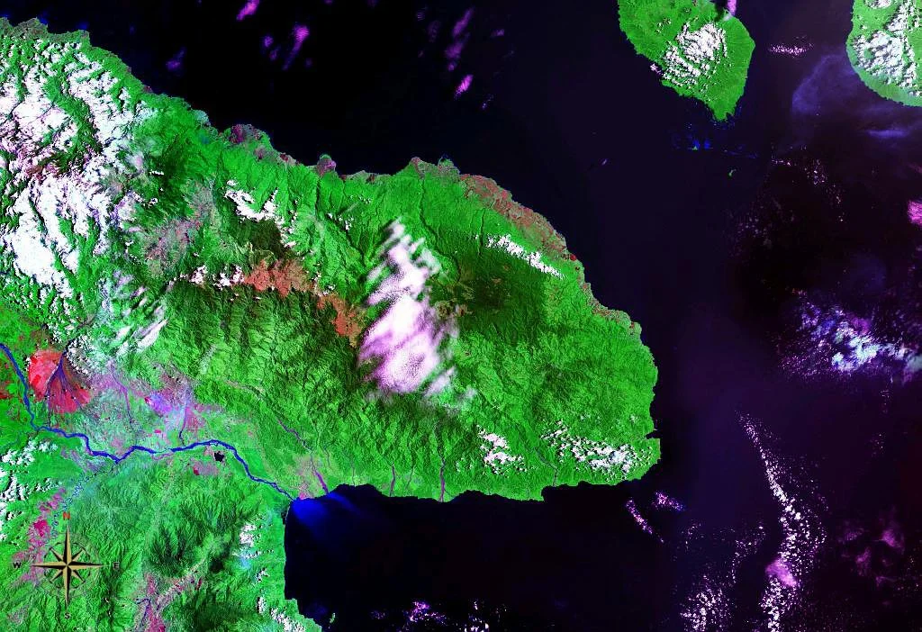
From the Air
The Huon Peninsula centers near 6.33°S, 147.42°E, extending from the north shore of the Huon Gulf (with Lae at its south-western base) northeast toward the Vitiaz Strait. The terrain is dominated by three parallel ranges: the Saruwaged (peaks over 4,100 m), Finisterre, and Cromwell Mountains. Lae airfield (Nadzab, AYNZ) is the main regional airport on the south side. The historic Saidor Airport lies on the north coast. Monsoon weather off the Solomon Sea builds dramatic cloud walls on the ranges. For high-altitude viewing, the raised coastal terraces are visible near Sialum on the north coast - a distinctive stepped pattern in the shoreline.
Nearby Stories
- Landing at Nadzab 30 km away
- Kaiser-Wilhelmsland 36 km away
- Madang and Morobe 36 km away
- Voco Point 53 km away
- Battle of John's Knoll and Trevor's Ridge 56 km away
- Dampier Strait (Papua New Guinea) 64 km away
- Battle of the Bismarck Sea 69 km away
- Battle of Cape Gloucester 117 km away