Battle of Cape Gloucester
The rain started on December 26, 1943, and did not really stop for a month. By the time the 1st Marine Division hit the beaches at Cape Gloucester that morning, seventeen months after their ordeal on Guadalcanal, they were the most experienced amphibious infantry in the Pacific. They were about to meet an enemy they could not shoot back at: the weather. Ten inches of rain a week. Kunai grass taller than a man, sharp enough to shred uniforms. Mangrove swamps that swallowed tanks. The Japanese 17th Division, dug in around two airstrips and a mountain, was in some ways the smaller problem.
Operation Backhander
Cape Gloucester sits on the northwestern tip of New Britain, 230 miles west of the massive Japanese base at Rabaul and 245 miles northeast of Port Moresby. It juts into the Bismarck Sea just north of the Vitiaz and Dampier Straits, the narrow passages between New Britain and the New Guinea mainland. Controlling those straits meant controlling convoy routes. Two Japanese airfields sat on the cape itself - not much to look at, a 3,900-foot strip and a shorter one, both grown over with kunai - but they threatened any Allied advance west. The operation, codenamed Backhander, was part of the larger Operation Cartwheel, General MacArthur's campaign to isolate Rabaul rather than assault it head-on. Lieutenant General Walter Krueger's Alamo Force drew the job. The 1st Marine Division, commanded by Major General William H. Rupertus, drew the landing. It would be their second major amphibious assault of the war.
The Landing
Before dawn on December 26, Task Force 76 under Rear Admiral Daniel E. Barbey began the naval bombardment - cruisers and destroyers hammering Japanese positions, followed by fourteen squadrons of American and Australian aircraft. The main landing came at Yellow Beaches 1 and 2 on the eastern side of the peninsula, near Silimati Point. The 7th Marines went in first. The 1st Marines followed through their lines, beginning the push north toward the airfields. A smaller diversionary force hit Green Beach to the west at Tauali, where they found the Japanese defenses abandoned. Initial resistance was light. The real enemy was the terrain. Swamp pressed in on both sides of the narrow coastal trail, funneling the advance into a single column. Sherman tanks mired axle-deep in mud. Trucks sank. Radios failed in the thick jungle - the Tauali force could not raise division headquarters and had to relay messages through Sixth Army instead.
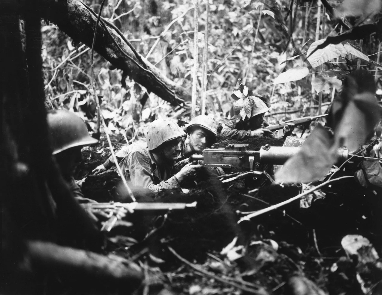
Hell's Point and Suicide Creek
That afternoon, Japanese aircraft from Rabaul finally arrived over the beaches. They sank the destroyer USS Brownson just offshore, killing 108 of her crew, and damaged two other destroyers. But the Marines got 13,000 men and 7,600 tons of equipment ashore on the first day, and the airfields fell within a week. On December 28, the 1st Marines hit the first serious defensive position on the coastal trail - a network of concealed bunkers with anti-tank guns and 75mm field pieces, known afterward as Hell's Point. Nine Marines were killed and 36 wounded breaking through; at least 266 Japanese defenders died holding it. Then came January and the ridges south of the airfields, where the 5th and 7th Marines fought the remnants of the Japanese 53rd and 141st Infantry Regiments for pieces of ground that the Marines named for the places they would always remember them by: Suicide Creek, Aogiri Ridge, Target Hill, Hill 660. On January 16, 1944, after three days of fighting in which 50 Marines and more than 200 Japanese soldiers were killed, the 7th Marines took Hill 660. Organized resistance ended. Major General Iwao Matsuda withdrew with roughly 1,100 survivors, leaving his command post behind intact.
The Cost
Casualties at Cape Gloucester amounted to 310 American dead and 1,083 wounded. Japanese killed exceeded 2,000. Those numbers tell only part of the story. Jungle rot, malaria, dysentery, and what the medical officers politely called "combat fatigue" gnawed at the division through January and February. Men slept in standing water for weeks. The 1st Marine Division had been withdrawn to Australia after Guadalcanal to recover; Cape Gloucester consumed that recovery. When the Army's 40th Infantry Division relieved them in late April, the Marines were exhausted, and the division needed a new period of rebuilding before the next fight. For the men who survived, Cape Gloucester would always be remembered in the same breath as Guadalcanal - another place the rain never stopped and the jungle fought back.
Was It Worth It?
Historians are not kind to Backhander. Lieutenant General George Kenney, the Fifth Air Force commander, had opposed the operation before it started. He believed the pace of the Pacific advance would outrun any airfield the Marines captured. He was largely right. The airstrip at Cape Gloucester was eventually built out - 5,200 feet of Marston Mat runway by March 1944, served by Royal Australian Air Force Kittyhawks of No. 78 Wing - but the Thirteenth Air Force units originally planned for the base were never sent. By August 1944 the plans were cancelled. Naval historian Samuel Eliot Morison called the whole operation a "waste of time and effort." The airfield did support the Admiralty Islands campaign in February 1944 and served as an emergency landing field into 1945. But in the broader arithmetic of Cartwheel, Cape Gloucester occupied a force, drew away Japanese attention, and was then mostly forgotten. The 310 Americans buried there, and the more than 2,000 Japanese soldiers who died defending it, did not know any of that. They fought the battle in front of them.
From the Air
Cape Gloucester sits at roughly 5.45 S, 148.43 E on the northwestern tip of New Britain. The peninsula extends into the Bismarck Sea with Mount Talawe (6,600 ft, extinct) at its base and Mount Langila (3,800 ft, semi-active) to the southwest. The airstrip site is at the peninsula's apex. Cruising altitude 10,000-14,000 ft reveals the distinctive coastal curve from Lagoon Point west to Borgen Bay east. Nearest airports: Hoskins (AYHK) about 90 nm east along the coast, Madang (AYMD) about 140 nm west across the strait. Expect heavy convective weather from December through February (the northwest monsoon), with afternoon thunderstorms possible year-round.
Nearby Stories
- Vitu Islands 72 km away
- Battle of Wareo 76 km away
- MV Rabaul Queen 100 km away
- Long Island, Madang Province 101 km away
- Battle of Talasea 107 km away
- Bismarck Archipelago 176 km away
- Karkar Island 237 km away
- Japanese Submarine Ro-103 338 km away