Madang and Morobe
Manam Island has been erupting almost continuously since 2004. For years its ash plume was a semi-permanent feature of the Bismarck Sea skyline, tall enough to show on satellite images, and despite recurring evacuations the islanders have repeatedly moved back to live beneath it. That willingness to negotiate with a volcano tells you something about Madang and Morobe provinces. Together they occupy the north-eastern shoulder of New Guinea, more than 900,000 people spread across mountain ranges, river valleys, active calderas, and forest so dense that fifteen thousand plant species have been catalogued and no one is confident that is the final count.
Madang's Quiet Boast
Madang town has called itself the prettiest city in the South Pacific for a long time, and locals will tell you to take that with a grain of salt. But the harbour really is picturesque, the reefs really are close enough that you can dive from a dinghy, and the carvers working in wood and shell produce some of the finest work in the Pacific. The province behind the town holds 365,000 people and Mount Wilhelm, at 4,509 metres the highest peak in the country, shared with Chimbu province across the border. Waterfalls drop hundreds of metres off the edges of the highlands. The Ramu river cuts through the middle, still navigable by dugout canoe for long stretches. The RamuNico nickel mine has made the coast anxious about what a future of tailings dumped at sea might look like.
Living on the Ring of Fire
Volcanic islands scatter the coast north and west of Madang town. Karkar Island sits thirty kilometres offshore, an oval of fifty thousand people farming coconut and cocoa on fertile slopes that last erupted in 1978. Its two nested calderas still smoke faintly. The inner crater can be climbed. Further out, Manam is the province's restless child, a near-perfect cone 200 kilometres to the northwest whose eruptions drove its islanders to the mainland for most of two decades. Bird life matches the geology in abundance. Multiple birds of paradise breed here. Butterflies grow huge. Somewhere between 200 different dialects are spoken across the province, which gives you a sense of how this landscape has concentrated human diversity.
Morobe's Working Coast
South across the provincial line sits Morobe, nearly 600,000 people organised around the Huon Gulf and the port city of Lae. Morobe has 171 languages on its own ledger. Tok Pisin, the English-based creole, holds them all together as the province's common tongue. Lae is the country's second city and its economic hub. Highland coffee comes down the Highlands Highway to Lae's wharves for export. Timber moves out of the Bulolo area. Oil and mineral exploration keeps expanding. The Markham Valley, which runs inland from Lae, is one of the country's most productive agricultural regions, an anchor of beef cattle and sugar in a country where flat, arable land is rare.
Tree Kangaroos and the Champagne Cork
The Huon Peninsula juts northeast from Lae into the Solomon Sea. Geologists have called it the champagne cork because its mountains are still pushing up fast enough to measure. One of Papua New Guinea's seven species of tree kangaroo, the Matschie's, lives in those forests. To see one in the wild you have to hike to 2,000 metres. In 2009 the YUS Conservation Area was established to protect the kangaroo's habitat in the peninsula's north, named for three rivers that drain it: the Yopno, Uruwa, and Som. The peninsula also holds Salamaua, a pre-war port just south of Lae reached by a one-hour boat trip. It was a thriving town before World War II. Now a single guesthouse sits beside warm reefs and the shallow wrecks of ships that did not survive the fighting.
The War Underfoot
You cannot spend long in these two provinces without the past coming up. Hansa Bay, on the Madang coast, holds the wrecks of thirty-five Japanese ships. The Black Cat Trail runs from Wau to Salamaua along the track gold prospectors used before the war. During World War II, some of the heaviest fighting in the South West Pacific happened along its length. Live mortars, munitions, plane wrecks, and huge bomb craters are still there for trekkers to step around. The Bulldog Trail, longer and harder, traces the route Japanese forces took south from Lae toward Wau after their defeats at Buna and Kokoda. Australian troops were supplied along it by local porters, the men whose endurance and knowledge of the country made much of the Allied campaign possible. Both provinces receive a steady stream of Japanese visitors making their own journey back to the ground where their grandfathers fought.
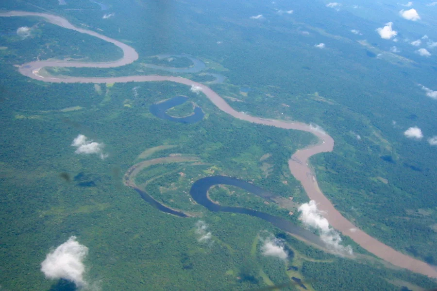
From the Air
Madang town sits at 5.22°S, 145.80°E; the provincial centroid is 6.03°S, 146.65°E. Flights into Madang Airport (AYMD) descend past the volcanic cones of Manam and Karkar. Lae is served by Nadzab Airport (AYNZ) in the Markham Valley, about 40 km inland. Cruise altitude of 8,000-10,000 feet offers dramatic views of the Finisterre and Saruwaged ranges, the Ramu and Markham rivers, and the reef-lined coast. Weather is typically best May through September, the dry season.
Nearby Stories
- Huon Peninsula 12 km away
- Landing at Nadzab 27 km away
- 1993 Finisterre Earthquakes 32 km away
- Vitiaz Strait 35 km away
- Ukarumpa 39 km away
- Airlines PNG Flight 1600 51 km away
- Battle of Wareo 68 km away
- Dampier Strait (Papua New Guinea) 101 km away