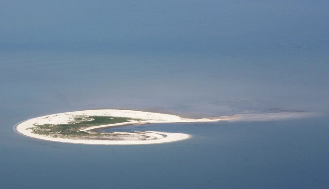
Lütje Hörn
Some islands stay put. Lütje Hörn does not. Since cartographers first started taking it seriously in the late nineteenth century, this tiny East Frisian sandbank has slid roughly two kilometers to the southeast and lost more than nine-tenths of its land area to the sea. Between 1961 and 1999 alone it migrated 600 meters eastward and 150 meters south. Storm by storm, it keeps walking. Watch the same patch of North Sea long enough and you can almost picture the island as a slow, restless animal, dragging its sand and its handful of dunes along the eastern channel of the Ems.
First Recorded in 1576
Lütje Hörn means roughly 'little horn' in Low German - a reference to its shape on the old maritime maps. It first appears in a 1576 sailing guide under the name Hooghe Hörn, written down by Frisian pilots who needed to warn captains away from the mudflats southeast of Borkum. For nearly three centuries after that, it stayed off the formal topographical record, showing up only in seafarer's lore. In 1859, Lower Saxon surveyors finally added it to the official maps. By then the island already had a personality: skinny, oriented north to south rather than east to west like its neighbors, and clearly subject to the moods of the Ems estuary. The other East Frisian islands - Borkum, Juist, Norderney, Wangerooge - run roughly parallel to the mainland. Lütje Hörn alone sits at right angles to the rest, swept that way by the currents pushing out of the river mouth.
The Shrinking Numbers
The arithmetic of Lütje Hörn's twentieth century reads like a slow demolition. In 1891 the island measured 61 hectares. By 1937 it was down to 54, the loss mostly chewed off by ordinary winter storms. In 1957 it still showed 58 hectares above the high-water mark, including roughly one acre of substantial dunes - enough vegetation to anchor sand and keep the place looking like a proper island. Then came February 1962. The great storm surge that flooded Hamburg and killed hundreds along the German coast tore through Lütje Hörn as well, peeling away dune faces and washing out salt marsh. The winter storms of 1989 and 1990 took another bite. By 1987 the island was down to 23 hectares. A few years after that, only 11. By the summer of 2006, NLWKN - Lower Saxony's coastal authority - reported that just 6.5 hectares of Lütje Hörn remained above the mean high-water line. The island had lost roughly 90 percent of its surface area in a century.
A Place Where Only Birds Land
Even with so little of it left, Lütje Hörn matters. It belongs to Zone I of the Wadden Sea National Park, the strictest protection category Germany applies. Access requires permission from the National Park Administration, which it almost never grants except to researchers. The reason is the same as for nearly every other small island in this sea: birds. The sandbar offers high ground in a tidal landscape with very little of it - a roosting site for waders and a nursery for terns and gulls during the breeding season. There are no buildings on Lütje Hörn. No lighthouse, no hut, no jetty. The island is an uninterrupted strip of sand and salt-tolerant vegetation, administered by the district of Leer in Lower Saxony as an unincorporated area, meaning no humans live there to govern. The unincorporated status is honest. It is also the only sensible designation for a place that may not exist in a recognizable form in another century.
Where Sand Goes to Walk
What is happening to Lütje Hörn is what happens to almost all the East Frisian islands, only faster. The currents in the Ems channel scour the western shoreline and dump sediment on the eastern side, so the entire island shuffles downstream over the decades. Borkum next door has migrated too, but slowly and on a much larger budget of sand. Lütje Hörn started small, and there is little reserve to draw from. Climate models suggest the rate of sea-level rise in the southern North Sea will outstrip the accretion rates that have kept the larger islands stable, and the smaller a sandbank is, the sooner it loses the fight. Whether Lütje Hörn survives the next big storm season, the next century, or the next thousand years - nobody can quite say. For now it remains, off the southeast tip of Borkum, a low strip of pale sand visible only at low tide, a German island that has spent four hundred years quietly walking away.
From the Air
Coordinates 53.58°N, 6.87°E, roughly 3 km southeast of Borkum in the eastern Ems channel. Recommended viewing altitude 1,500-3,000 ft for the clearest sense of the island's distinctive north-south orientation and its position relative to neighboring sandbanks. The Randzelwatt mudflats surround the island and are exposed at low tide; bring a tide table. Nearest airports: Borkum (EDWR) just 5 km to the northwest, Emden (EDWE) on the German mainland 35 km south, Eemshaven heliport (NL) just across the estuary. Low approaches during breeding season (April-July) are strongly discouraged - the island is a protected bird sanctuary.
Nearby Stories
- Battle of Jemmingen 1.3 km away
- Gaarkeuken Lock 1.8 km away
- Ewiges Meer 3.9 km away
- Organ at the Dorpskerk at Noordbroek 6.7 km away
- Schiermonnikoog National Park 7.5 km away
- German Trawler V 1101 Preussen 19 km away
- HVDC DolWin2 22 km away
- Gemini Wind Farm 36 km away