_02.jpg)
MacDonnell Road
Since 2023, Chinese tourists have been stopping at a street sign on a steep Mid-Levels road to photograph themselves holding McDonald's bags. The joke writes itself: the Chinese transliteration of MacDonnell Road and the Chinese name of the fast-food chain are identical, character for character. When McDonald's opened its first Hong Kong restaurant in January 1975, the company chose the name deliberately, citing MacDonnell Road as a 'well-known local street.' The road had been there since 1891 — running westward from Garden Road through the elevated residential district above Central, one of the most expensive addresses on Hong Kong Island. That a Victorian-era colonial street and a global burger franchise should end up sharing a name in Chinese is the kind of collision that Hong Kong, a city built on collisions, tends to produce without apparent effort.
A Road with Imperial Ambitions
Construction of MacDonnell Road began in 1891 and the first section was complete the following year. By 1899, the road had been extended eastward to form a junction with Bowen Road. The colonial government was offering crown land lots along the road on 999-year leases as early as 1896 — a remarkable term that the government ceased extending after May 1898. Only a limited number of plots on Hong Kong Island and in Kowloon retain such leases today, making MacDonnell Road properties among the most durably titled land in the territory.
The road was named for Richard Graves MacDonnell, governor of Hong Kong from 1866 to 1872. It runs through the Central Mid-Levels alongside a handful of other elite streets — Old Peak Road, Magazine Gap Road, Tregunter Path, Bowen Road — all of them pressed into the steep terrain between the financial district of Central and the summit of Victoria Peak. In 1903, parts of the road were infested with anopheles mosquitoes, and malaria was recorded in the district. The colonial authorities cleared the nearby nullahs as a preventive measure.
Before the War and During It
In the decades before the Second World War, the streets below Victoria Peak were home to a cosmopolitan mixture of residents. Wealthy Japanese nationals were living as high up as MacDonnell Road — a detail that carries ironic weight given what came next. In December 1941, during the eighteen-day Battle of Hong Kong, the headquarters of the 2/14th Battalion, Punjab Regiment was established on MacDonnell Road.
The 2/14 Punjab formed part of the West Brigade, responsible for the northwestern shore of Hong Kong Island from Causeway Bay to Belcher's Point. Their defensive area included the Governor's House and the headquarters of Major General Maltby. One resident of the road, a man named E.H. Ray whose grandniece Joyce Symons would later become an educator and public figure, had his house commandeered by the military during the battle. The colony surrendered on Christmas Day 1941. MacDonnell Road, like the rest of Hong Kong, spent the next three years and eight months under Japanese occupation.
Names and Their Meanings
The Chinese name of MacDonnell Road was changed in April 1957, from a character meaning 'slave' to one meaning 'labor' — the negative connotation of the original transliteration having become, by midcentury, an embarrassment that the authorities chose to address. It was a small change with real weight: the road's spoken Cantonese name was identical either way, but the written character carried different freight.
A 1904 book called *English Made Easy*, written by Mok Man Cheung and published in Hong Kong, listed the road as 'Mac Donald Road' — a spelling that anticipated the McDonald's coincidence by seventy years. When the fast food chain arrived in Hong Kong in January 1975 and adopted the road's Chinese name as its own, the loop closed. Today, the restaurant chain and the street that inadvertently named it coexist in the same city, their shared identity a minor footnote in Hong Kong's linguistic history.
The Buildings That Remain
MacDonnell Road is lined with buildings that hold more history than their current facades suggest. The Hong Kong Branch of the First Church of Christ, Scientist, at No. 31, was built in 1912 and is the only Christian Science branch in Hong Kong; its 1956 annexe makes it larger than it looks. The building is listed as a Grade II historic building. At No. 33, St. Paul's Co-educational College was founded in 1915 as St. Paul's Girls' College, relocated to this address in 1927, and became Hong Kong's first co-educational school in 1945. Its 1927 building is also Grade II listed.
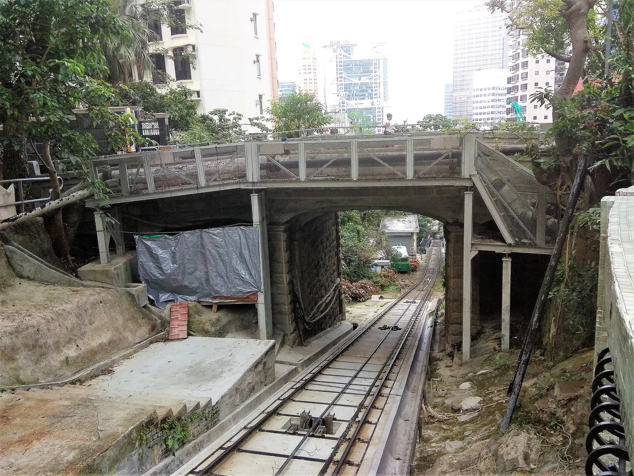
The MacDonnell Road Bridge, where the road crosses the Peak Tram tracks, was rebuilt in reinforced concrete supported by granite columns in 1938 — the current structure replacing an older one that the colonial authorities judged insufficient. The bridge sees steady pedestrian traffic from the MacDonnell Road tram stop, one of the intermediate stations on the historic Peak Tram route.
Residents Past and Present
Lee Shau-kee, one of Hong Kong's most prominent property developers, lived with his family in the penthouse of Eva Court at 36 MacDonnell Road from 1984 into the 2010s. The 22-storey residential building was developed for the Lee family and named after his ex-wife, Lau Wai-ken. When Lee moved on, he purchased a plot on The Peak for HK$1.82 billion in 2010 — at the time, the most expensive residential site in the world on a per-square-foot basis.
Kenny Bee, the Hong Kong singer, musician, and actor, grew up on MacDonnell Road. In December 2007 he published an autobiography titled after the street he was raised on. The western half of MacDonnell Road is now part of the Central Route of the Central and Western Heritage Trail, connecting the First Church of Christ, Scientist and St. Paul's Co-educational College to the broader historic precinct of Central. The road is served by the Peak Tram's MacDonnell Road stop and two bus routes — ordinary infrastructure for an address that has never been entirely ordinary.
From the Air
MacDonnell Road runs at approximately 22.2756°N, 114.157°E through the Central Mid-Levels, on the steep northern face of Hong Kong Island. The road is not directly visible from altitude, but the Mid-Levels district — a dense residential band clinging to the hillside above the Central financial district — is clearly distinguishable from the harbor. Approaching VHHH (Hong Kong International Airport) from the west, the island's north face rises sharply from the waterfront; the Peak Tram route, visible on maps, climbs through the Mid-Levels roughly parallel to MacDonnell Road. The Central-Mid-Levels escalator system, the world's longest covered outdoor escalator, runs nearby. Recommended viewing altitude for the overall area is 2,000–3,000 feet on a harbor transit.
Nearby Stories
- Lok Ma Chau Loop 2.3 km away
- Portas do Cerco 2.3 km away
- Kweilin Incident 17 km away
- Wanshan Archipelago Campaign 34 km away
- Nanxiong Formation 115 km away
- Battle of Nanpeng Island 148 km away
- Heyuan 169 km away
- Cape Maobitou 632 km away