
Machars
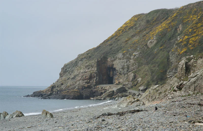
The name comes from the Gaelic word machair, meaning low-lying or level land, the kind of soft green ground that east-coast Scots call links. It is a deliberately gentle name. The Machars is not flat, exactly, but it is undulating where the rest of Galloway is steep, and the rolling pasture, the dairy herds, and the mild Gulf-Stream air make it one of the softest stretches of coast in southern Scotland. Dolphins and basking sharks come close inshore. A forty-mile coastline curls around the peninsula, and on it sits almost every story Galloway has to tell.
A Coastline With Everything
Start at the mud-flats of Wigtown on Wigtown Bay and travel south. The shore becomes the sandy beach at Rigg Bay in Garlieston, where the Mulberry Harbours were trialled in secret in 1943. Past Garlieston, the cliffs rise to the ruined arch of Cruggleton Castle on its shale promontory. The land drops at Portyerrock Bay and the Isle of Whithorn, then rises again at Burrow Head, where the climax of The Wicker Man was filmed in 1972. Round the southern tip, the shore enters Luce Bay; cliffs continue to the sandy beach at Monreith, childhood home of Gavin Maxwell, and on past Port William. Rocky shore, sandy beaches, dunes near Glenluce. Two rivers cut through it all: the River Bladnoch, rising at Loch Maberry, and its tributary the Tarf Water meeting it near Kirkcowan.
Saint Ninian's Quiet Claim
Saint Ninian brought Christianity to Scotland through the Machars. He founded a small church at what is now the Isle of Whithorn around the late 4th century, and Whithorn itself grew into the seat of a medieval cathedral. Ninian had studied under Saint Martin of Tours, and his mission predates the better-known one of Saint Columba at Iona by more than a century. Columba's Iona is often credited as the cradle of Scottish Christianity; the people of the Machars will tell you, politely but firmly, that the cradle was here. The Pilgrim's Way still threads twenty-five miles from Glenluce Abbey through the peninsula to Whithorn and on to St Ninian's Cave. Standing stones at Drumtroddan and Torhousekie stone circle remind any walker that the path is older than the saints who used it.
Two Halves, Two Landscapes
The eastern Machars is dairy country, all rolling green hills and scattered woodland, perfect for the big herds that once supplied a creamery at Sorbie. The north-west of the peninsula is a different world entirely. Above the raised beaches of Luce Bay rises a rugged moorland of peat bog and low stony ridges, with many small lochs scattered through it. This is forestry country, dominated by Sitka spruce plantations, and stock-rearing country for hardy Belted Galloways and the dark-red Galloway cattle. Mochrum Fell is the highest point. The Castle Loch near the Old Place of Mochrum still hides the remains of several crannogs, those Iron Age artificial islands built out into open water for defence.
Wartime Wigtown
In 1941 the Air Ministry opened RAF Wigtown, often called Baldoon, on the carse near Kirkinner. It served as a training school in the Second World War, hosting No. 1 Air Observers School from September 1941 to February 1942 and operating with a tracked target range along the coast. The first grass runways flooded, so two concrete strips went in during 1942. The airfield closed in 1948. Today its control tower still stands and many of the perimeter and access roads remain visible. Walkers and cyclists use them. Across the peninsula, the smuggling routes that once connected Burrow Head to the Point of Ayre on the Isle of Man, eighteen miles south, have faded into history, but the tourist trade that has replaced smuggling and farming as the main local industry has not yet displaced the deep memory of either.
From the Air
The Machars peninsula occupies roughly 54.7-54.9N, 4.2-4.6W, bounded by Wigtown Bay to the east and Luce Bay to the west. From cruising altitude the peninsula reads as a soft green wedge between two deep bays, with Burrow Head and the Isle of Whithorn as the prominent southern landmarks. Best viewed at 3,000-6,000 ft. Cruggleton Castle, the Isle of Whithorn cairn, and the old RAF Wigtown airfield are all useful waypoints. Nearest airports: Dumfries (EGDD), Prestwick (EGPK), and Isle of Man Ronaldsway (EGNS) across the Solway. On clear days the Lake District and the Isle of Man are both visible.
Nearby Stories
- Ardwell 2.1 km away
- Point of Ayre Lighthouse 8.7 km away
- Battle of Glen Trool 9.8 km away
- Ballantrae Lifeboat Station 11 km away
- Solway Firth 13 km away
- Dumfries 17 km away
- St Bees Lifeboat Station 17 km away
- Portavogie 34 km away