
Machrie Moor Stone Circles
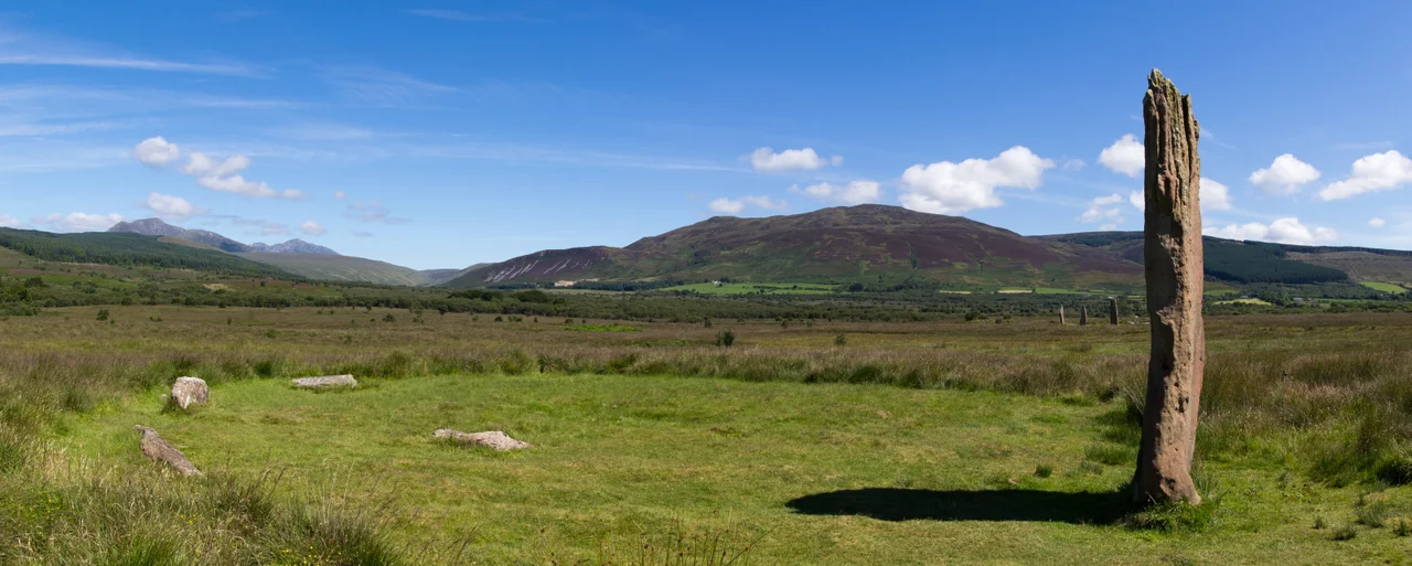
Walk east from the derelict Moss Farm on the Isle of Arran and the heather opens onto a flat moor. The first thing you see is a standing stone — red sandstone, weathered, taller than a person. Then another. Then another. Six stone circles are visible here, each one made by people who lived more than four thousand years ago. The most prominent stones at Machrie Moor 1 reach close to five metres into the wet Hebridean sky. Radiocarbon dating of the timber circle that once stood at the same site puts its construction at around 2030 BCE — give or take 180 years. These people were doing something deliberate. At the summer solstice, the rising sun strikes a particular notch in the hills beyond, illuminating the circles. The placement was not casual.
Granite and Sandstone
The six circles on Machrie Moor were built from two different stones. Some are made of granite boulders, rounded and hard, dragged by glacial action from elsewhere on the island. Others are formed of tall red sandstone slabs, quarried from local outcrops and stood upright like ribs against the sky. The contrast was not accidental. Machrie Moor 1 — perhaps the most impressive — is an ellipse with axes of 12.7 and 14.6 metres, alternating six granite boulders with five sandstone pillars. The heights of the three still-intact stones range from 3.7 to 4.9 metres. Only one stands fully upright today, 4.3 metres high. The stumps of others are still visible, partly submerged in the slow-rising peat that has covered much of this moor over the millennia.
What the Circles Held
When excavators dug into Machrie Moor 1 in 1861, they found a cist near the centre — a stone-lined burial chamber, evidence that whatever ceremonial purpose the circles served, it included connection with the dead. The inner circle is 12 metres in diameter and consists of eight granite boulders, the tallest about 1.2 metres high on the western side. Machrie Moor 7 is a single standing stone, 1.6 metres tall. Machrie Moor 8 is the remains of a probable chambered cairn — an oval spread of stones roughly 20 by 16 metres, with a 1.8 metre standing stone at its eastern edge surrounded by smaller stones that may once have formed a chamber or façade. Machrie Moor 10 is the Moss Farm Road Stone Circle. The numbering is unromantic, but it conceals a varied and complicated ritual landscape.
Buried and Forgotten
Many of these monuments were lost to peat. Peat grows slowly, but over four thousand years it grows enough to bury whole rows of standing stones. When a further stone circle was discovered almost completely submerged in 1978, it was given the number Machrie Moor 11. There is no telling how many more lie beneath the surface, waiting either for chance discovery or for the right cut of a peat spade. Around 1.2 kilometres east of the main circles, near the B880 road, is another stone-setting of three granite boulders that may originally have been four. The whole moor, in other words, was a single deliberately marked landscape — a place where people came to build, to bury, to gather, and to mark the year by the sun's position on the longest day.
Why Here
What we do not know about the people who raised these stones could fill libraries. Their language, their gods, their reasons for choosing the alternation of granite and sandstone — all of it has been lost. What survives is the result of their decisions. The summer solstice alignment suggests they tracked the sun carefully. The cist burials suggest they tended their dead with ceremony. The labour involved in moving and raising stones nearly five metres tall, in a society without metal tools, was substantial — and that labour was given. These were people who decided this place mattered enough to build for it. Today the moor is wet and quiet, the sheep move through the stones, and Historic Environment Scotland looks after the site. The circles still mark the solstice. They have been doing it for forty centuries.
From the Air
Machrie Moor lies on the west coast of the Isle of Arran at approximately 55.54 degrees north, 5.31 degrees west. The site is east of the small settlement of Machrie and the derelict Moss Farm. From altitude, look for the broad flat moor between the coast and the granite hills that rise toward Arran's interior, with the prominent stones at Machrie Moor 1 visible as small vertical marks against the heather. Glasgow Prestwick (EGPK) is roughly 30 nautical miles east across the Firth of Clyde. There is no airport on Arran itself. Weather is mild oceanic, with frequent low cloud and rain rolling in off the Atlantic — clear days are best for spotting the stones, and best for understanding why the solstice alignment was worth building for.
Nearby Stories
- Great Cumbrae 5 km away
- Dunure Castle 12 km away
- Islay 12 km away
- Cushendall 14 km away
- Dunyvaig Castle 22 km away
- Tighnabruaich Lifeboat Station 25 km away
- Ballantrae Lifeboat Station 30 km away
- Battle of Glen Trool 30 km away