Madura: Salt, Bulls, and the Island That Emptied Itself
Every autumn, a young boy grips a wooden sled hitched to two bulls and holds on as the animals explode across a hundred-meter dirt track. The race lasts ten to fifteen seconds. The crowd -- farmers, fishermen, families from villages where maize fields run to the horizon -- erupts. This is karapan sapi, Madura's famous bull-racing tradition, and it captures something essential about the island: a place that has made spectacle out of scarcity, culture out of hardship, and identity out of a landscape that offers little easy wealth. Madura sits just off the northeast coast of Java, separated by a narrow strait now spanned by Indonesia's longest bridge. It is home to roughly four million people, but the Madurese diaspora is far larger -- some seven million strong, scattered across eastern Java and beyond. More Madurese live off the island than on it, a fact that says everything about Madura's stubborn, complicated relationship with prosperity.
Princes, Treaties, and the Cape of Good Hope
Madura's political history reads like a chess match played across centuries, with Javanese sultans, Madurese princes, and Dutch colonizers trading moves. In 1624, Sultan Agung of the Mataram Sultanate conquered the island and placed it under the Cakraningrat dynasty, a single princely line that proved far more ambitious than their overlords expected. The Cakraningrats repeatedly challenged Central Javanese authority, conquering large portions of Mataram's territory whenever opportunity arose. When the First Javanese War of Succession erupted between Amangkurat III and his uncle Pangeran Puger, the lord of West Madura backed Puger's claim -- hoping, it seems, that Javanese civil war would open space for Madurese expansion. The gambit partly worked, but the real winner was the Dutch East India Company, which gained control of eastern Madura in 1705. By 1743, sovereignty over the entire island had been ceded to the Dutch. Cakraningrat IV, who contested the handover, fled to Banjarmasin, sought British protection, was betrayed, captured, and exiled to the Cape of Good Hope. His story encapsulates colonial-era Madura: a place where local power was real but never quite sufficient to resist the larger forces closing in.
A Landscape of Limestone and Salt
Madura is geologically an extension of Java's northern limestone range, but lower, rougher, and drier. The hills are rounded rather than dramatic, the soil thin and calcium-rich -- productive for tobacco and cloves but hostile to the rice paddies that made neighboring Java one of the most fertile islands in Asia. This geological misfortune shaped everything. Where Javanese farmers grew surplus rice, Madurese farmers grew subsistence maize on small landholdings that rarely generated wealth. What the island did produce was salt. The flat, sun-baked coastline proved ideal for evaporation ponds, and by the second half of the nineteenth century Madura had become the primary salt supplier for the entire Dutch-controlled archipelago. The trade persists today. Drive the island's coastal roads and the salt pans stretch in geometric grids, their shallow water catching the equatorial light in bands of white and pale blue. The climate -- tropical savanna under the Koppen classification, warmer and drier than mainland East Java -- is the salt industry's silent partner.
The Diaspora Next Door
Madura's thin soil and limited economic opportunities created one of Indonesia's most striking demographic patterns: chronic emigration so sustained that the majority of ethnic Madurese no longer live on the island. The eastern arc of East Java, commonly called the Horseshoe, is heavily Madurese -- towns like Situbondo, Bondowoso, and parts of Jember have Madurese-speaking majorities. Many families participated in government transmigration programs that relocated Indonesians from crowded islands to less populated ones. Others simply left for Surabaya, Indonesia's second-largest city, which sits just across the strait. The opening of the Suramadu Bridge in 2009 -- at 5.4 kilometers, the longest bridge in Indonesia -- tightened that connection. Bangkalan, the regency at Madura's western tip, has industrialized since the 1980s and functions increasingly as a Surabaya suburb. Commuters cross the bridge daily, living on an island whose interior remains agricultural and poor while its western edge merges into the metropolitan economy of a city of three million.
Drums, Masks, and the Sound of Bamboo
Cultural life on Madura runs deeper than the bull races, though those get the headlines. The island sustains several performance traditions rooted in village life. Topeng theatre -- masked performances of the Ramayana and Mahabharata -- is Madura's best-known art form nationally, regularly featured at exhibitions of Indonesian regional culture. Ironically, actual performances on Madura itself are rare, reserved for large official functions. The more popular form is loddrok, an unmasked theatre with a wider range of themes that draws crowds in towns and villages across the island. Music accompanies nearly everything. The gamelan orchestras at Madura's former royal courts, particularly those at Bangkalan and Sumenep, are elaborate and historically significant. More distinctively Madurese is tongtong music, played on wooden and bamboo drums, its driving rhythms inseparable from the bull races they often accompany. And the Madurese are sailors as well as farmers. Traditional vessels -- the golekan, the leti leti, the janggolan -- once carried cargoes of Borneo timber between Indonesia and Singapore, a maritime tradition that predates the colonial era and endures in diminished form along the island's coasts.
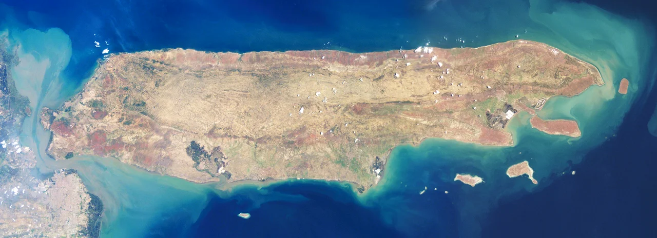
From the Air
Madura lies at approximately 7.04S, 113.30E, stretching east from Surabaya across the Java Sea. From altitude, the island is clearly visible as a long, relatively flat landmass north of Java's eastern bulge, connected by the Suramadu Bridge at its western end. Salt pans along the coast catch sunlight distinctively. The island's terrain is low limestone hills with no significant peaks. Nearest major airport is Juanda International Airport (WARR/SUB) at Surabaya, approximately 30 km southwest of Bangkalan across the strait. Trunojoyo Airport (WART) at Sumenep on Madura's eastern end handles small aircraft. Weather is tropical savanna; dry season (June-October) brings clearer visibility.
Nearby Stories
- The Submarine That Refused to Stay Down 9.7 km away
- The Bridge That Took Half a Century 11 km away
- The Collector Who Could Not Stop 16 km away
- The Kedopok War: When Probolinggo Rose Against Its Buyer 48 km away
- When Sapudi Shook at Dawn 62 km away
- Bengawan Solo: Java's River of Deep Time 89 km away
- Java's Little Africa 94 km away
- Forty Hours in the Masalembo Sea 177 km away