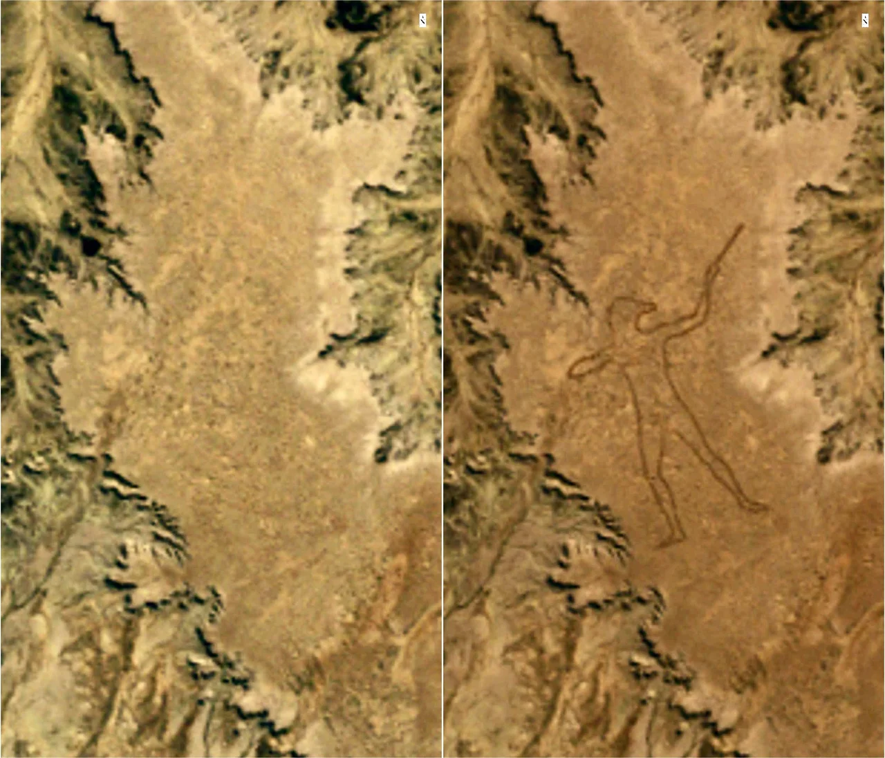

Marree Man
On 26 June 1998, a charter pilot named Trec Smith was flying between Marree and Coober Pedy when he looked down and saw a man. Not a person on the ground, but a man drawn into the ground - a colossal outline of a hunter, mid-stride, arm raised to throw, sketched across an entire plateau in lines cut into the red earth. The figure stood 2.7 kilometres tall, with a perimeter of 28 kilometres, sprawling over roughly two and a half square kilometres of desert near Finniss Springs, west of the town of Marree. It is one of the largest geoglyphs on the planet. And here is the part that still unsettles: nobody saw it being made, nobody filmed it, and to this day no one has credibly confessed to creating it. A figure visible from space simply appeared in one of the emptiest corners of Australia, as if drawn overnight by an invisible hand.
A Whodunit Written in Sand
The forensics, at least, are clear. Comparing satellite images, investigators pinned the creation to a narrow window: on 27 May 1998, a NASA Landsat-5 pass showed the plateau undisturbed; by 12 June, the completed figure was there. Whoever did this carved lines up to 35 metres wide and shifted earth across kilometres of terrain - work that experts concluded required an earthmoving machine and an expert grasp of satellite-guided positioning, then a cutting-edge and barely available technology. The audacity is staggering. Someone moved heavy equipment into remote country, executed a drawing the size of a city, and vanished without leaving a single eyewitness behind. The desert kept the secret completely. In a modern world saturated with cameras and records, the Marree Man is a genuine mystery: a monumental act of creation with no confirmed author.
The American Red Herrings
The clues that did surface only deepened the puzzle - and may have been designed to mislead. A series of anonymous faxes arrived at media outlets and local businesses, dubbing the figure 'Stuart's Giant' after the explorer John McDouall Stuart. Their wording was conspicuously un-Australian: references to 'your State of SA', the 'Queensland Barrier Reef', and a nod to Ohio's Great Serpent Mound, an earthwork few outside the United States would know. A glass jar was reportedly unearthed at the site holding a satellite photo and a note bearing a U.S. flag. Later, a fax described a buried plaque stamped with the American flag and the Olympic rings. It all pointed across the Pacific - which is precisely why some suspected the American flavour was theatre, planted to throw investigators off an Australian trail. One name that surfaced was Bardius Goldberg, an Alice Springs artist with a taste for the grand gesture, the know-how, and access to machinery. Goldberg never confirmed it, and he took whatever he knew to his grave in 2002.
An Image Made Without Asking
For all the public delight at the riddle, the Marree Man raised a harder question that the headlines often skipped. The figure depicts an Aboriginal man hunting - rendered, it later emerged, after photographs in a 1946 book describing hunters of the Pitjantjatjara language group - yet it was bulldozed onto country sacred to others, by an outsider who never asked. At the time, the land was the subject of a native title dispute between the Arabana and Dieri Mitha peoples. The Dieri Mitha spoke out against what they saw as harm to and exploitation of their Dreaming, calling for the image to be erased and its maker held to account. Their objection cuts to something real: a stranger had seized the likeness of Aboriginal identity and carved it across Aboriginal land as a spectacle, without consent or consultation. Officials condemned the work too - the state environment minister called it vandalism. In 2012, the Federal Court recognised the Arabana people as the land's traditional owners.
The Giant Refuses to Fade
Deserts erase things, and the Marree Man began to dissolve almost at once, its lines softening year by year under wind and the rare rain. By 2016 the figure had nearly vanished back into the plateau. Then, with the consent of the Arabana Aboriginal Corporation, a group of locals decided not to let the giant disappear. Using a commercial grader steered by GPS, they spent some sixty hours re-cutting the entire outline, matching the original so precisely that it underscored an irony two decades in the making: a figure that could scarcely have been created without GPS in the first place. The Marree Man strides again across his plateau, sharp enough to see from a passing plane. He remains exactly what he was on the day a startled pilot first spotted him - vast, silent, and unclaimed. The land beneath him has its rightful owners. The figure above it still belongs to no one.
From the Air
The Marree Man lies at approximately 29.53°S, 137.47°E, on a plateau near Finniss Springs about 60 km west of the township of Marree in South Australia's Far North, just outside the Woomera Prohibited Area. The geoglyph is best - indeed only - appreciated from the air: from altitude the full hunting figure resolves, arm raised, against the flat ochre plateau. Note that vehicle access to the site has historically been restricted out of respect for traditional owners, but overflight is the traditional way to view it. The nearest airfield is Marree (ICAO YMRE) to the east; William Creek (YWMC) lies to the north-west and is a common scenic-flight base; Leigh Creek Airport (YLEC) lies to the south. Several outback air operators run dedicated flights over the figure, often combined with Kati Thanda-Lake Eyre to the north-west. Expect excellent dry-season visibility but heat shimmer and few ground references; recommended viewing altitude 2,000-4,000 ft AGL to frame the entire 2.7 km figure.
Nearby Stories
- Farina railway station 41 km away
- Strangways Springs 52 km away
- Anna Creek Station 61 km away
- Ediacara Hills 70 km away
- Killalpaninna Mission 75 km away
- Olympic Dam mine 85 km away
- Beltana Station 120 km away
- William Creek 134 km away