
Medway Megaliths
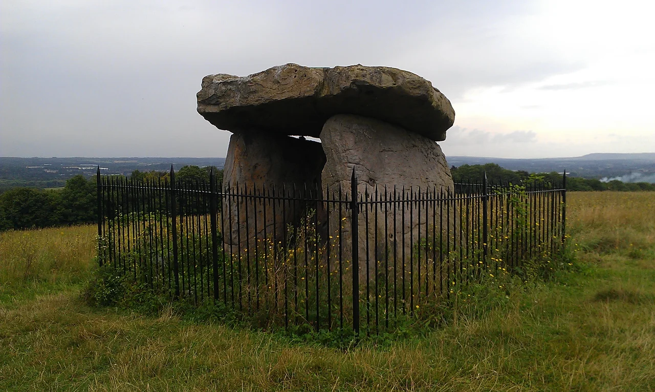
On Blue Bell Hill, looking east across the valley of the River Medway, Kit's Coty House still stands - three uprights and a capstone, a stone table that has been on this hillside since people in Britain had only just stopped being hunter-gatherers. Samuel Pepys came to see it in 1669. William Stukeley drew it in 1722. Local children once tried to count its companion stones at Little Kit's Coty House and were defeated, the folktale said, by the Devil himself - which is how those stones earned the name "the Countless Stones." The Medway Megaliths are the southeasternmost cluster of prehistoric megalithic tombs in the British Isles, and the only group in eastern England. They were built around 4000 BCE. Every visible piece of them is at least six thousand years old.
The Tradition That Crossed the Channel
Between 4500 and 3800 BCE, the communities of the British Isles changed how they lived. They stopped hunting and gathering as their primary food source and began herding cattle, growing cereals, building permanent settlements. Whether this came about because new farmers crossed from the European continent, or because the indigenous Mesolithic Britons adopted continental techniques, remains debated. Either way, the change emerged from contact across the English Channel - and Kent, sitting at the closest point of approach, was where it began. The Early Neolithic was also when humans across Western Europe first started constructing monumental architecture in the landscape. Long earthen mounds with stone chambers, called chambered long barrows, were built from southern Sweden to southeastern Spain. The Medway Megaliths represent the easternmost of these traditions in Britain - a regional variant whose closest stylistic parallels lie in the Low Countries, in Germany, or possibly in Scandinavia, depending on which archaeologist you ask.
Two Clusters Across the River
The monuments divide into a western group on the river's western bank, and an eastern group on Blue Bell Hill across the water. The two clusters sit about 8 to 10 kilometres apart. To the west: Coldrum Long Barrow, the best-preserved of the surviving tombs and now owned by the National Trust as a memorial to the local historian Benjamin Harrison; Addington Long Barrow, now bisected by a road; and Chestnuts Long Barrow, whose mound has eroded entirely but whose stones, partially re-erected, survive on private land. To the east: Kit's Coty House and Little Kit's Coty House, with their dramatic surviving uprights; the Coffin Stone, a great rectangular sarsen lying flat; the now-destroyed Smythe's Megalith, plundered by farm labourers in 1822; and the White Horse Stone, whose status as part of a barrow remains uncertain. All the long barrows shared a common plan - aligned east-west, with the stone chamber at the eastern end. They were built taller than most other British chambered tombs, with internal heights reaching ten feet.
The Living and the Dead
In 1998 and 1999, the Oxford Archaeological Unit excavated near the White Horse Stone, ahead of construction work on the Channel Tunnel Rail Link. They found a Neolithic longhouse - eighteen metres long, eight metres wide - of a type built across central and north-western Europe. Radiocarbon dates put it at 4110 to 3530 calibrated BCE. A smaller circular building lay just southeast of it. The excavators suggested the longhouse may have been a "house of the living" intervisible with the "houses of the dead" up on the hill. Another possibility: the longhouse was itself part of the funerary tradition - a place where bodies were prepared before being placed in the chambers, or where communal feasting honoured the dead. Either reading places the megaliths inside a wider ritualised landscape, a ceremonial geography in which the living and the ancestors faced one another across the valley. A causewayed enclosure - the largest known in Kent - was found at Burham, dating from 3700 to 3400 BCE.
The Smashing of the Tombs
In the late 13th century, somebody set out to destroy the Medway Megaliths systematically. Some chambers were toppled. Others were dug into. Stones were buried. Excavation at Chestnuts Long Barrow has confirmed deliberate medieval damage in the 12th or 13th century, and similar destruction is recorded at Coldrum, Addington, Kit's Coty, and Lower Kit's Coty. Why this happened is debated. The archaeologist Paul Ashbee thought it was Christian iconoclasm - a renewed church campaign to defame pre-Christian monuments during the reigns of Edward I and Edward III, around the time the Northern Crusade was carrying Latin Christianity into pagan Lithuania. The construction of St Stephen's Church at Tottington, St Michael's at Cosington, and St Margaret's at Addington, all near the megaliths, may have been part of the same effort. The archaeologist John Alexander argued for a more mundane motive: medieval treasure-hunting, perhaps under a special commissioner, on the model of the Close Roll of 1237 which ordered the opening of barrows on the Isle of Wight in search of buried valuables. Whichever it was, the tombs were broken.
Antiquarians, Pagans, and Folk Tales
Antiquarian interest began in the late 16th century with William Lambarde, who in his "Perambulation of Kent" compared Kit's Coty to Stonehenge and connected it to the legendary Anglo-Saxon hero Catigern. William Camden picked up the discussion in his "Britannia," making the site a tourist destination. Samuel Pepys visited in 1669 and wrote it up in his diary. John Aubrey, William Stukeley, Augustus Pitt Rivers, O.G.S. Crawford - the entire roll of English antiquarianism and early archaeology eventually came through Blue Bell Hill. Folktales gathered like moss. The Countless Stones could not be counted, because the Devil would add or subtract loaves of bread placed on them. Kit's Coty had been built by three witches assisted by a fourth. Two kings of Kent had died in battle nearby and been buried under the stones. In the latter 20th century, Druidic and Heathen Pagan groups began to use the sites for ceremony - Roharn's Grove, the Odinic Rite, Woden's Folk - finding spiritual significance in the same monuments medieval Christians had once tried to obliterate. The stones outlived them all.
From the Air
Located at approximately 51.32 north, 0.51 east, on both sides of the River Medway around Blue Bell Hill, roughly 4 miles north of central Maidstone. The eastern monuments cluster around Aylesford and Burham; the western group lies near Trottiscliffe and Addington. London Gatwick (EGKK) is about 22 nautical miles west; Manston (EGMH) is 28 nm east. From the air the valley is a green corridor of fields cut by the M20 motorway and the A229; the individual stones are too small to see, but the landscape's organisation - the river, the hill, the chalk downs - has not changed since the tombs were built.
Nearby Stories
- Blackwall Tunnel 0.2 km away
- London Gateway 2.6 km away
- Canterbury Castle 4.2 km away
- Battle Abbey 7.4 km away
- Plymouth Brethren 9.9 km away
- The Carrington Event: The Solar Storm That Could Happen Again 12 km away
- Clacton Pier 32 km away
- 2008 Channel Tunnel fire 42 km away