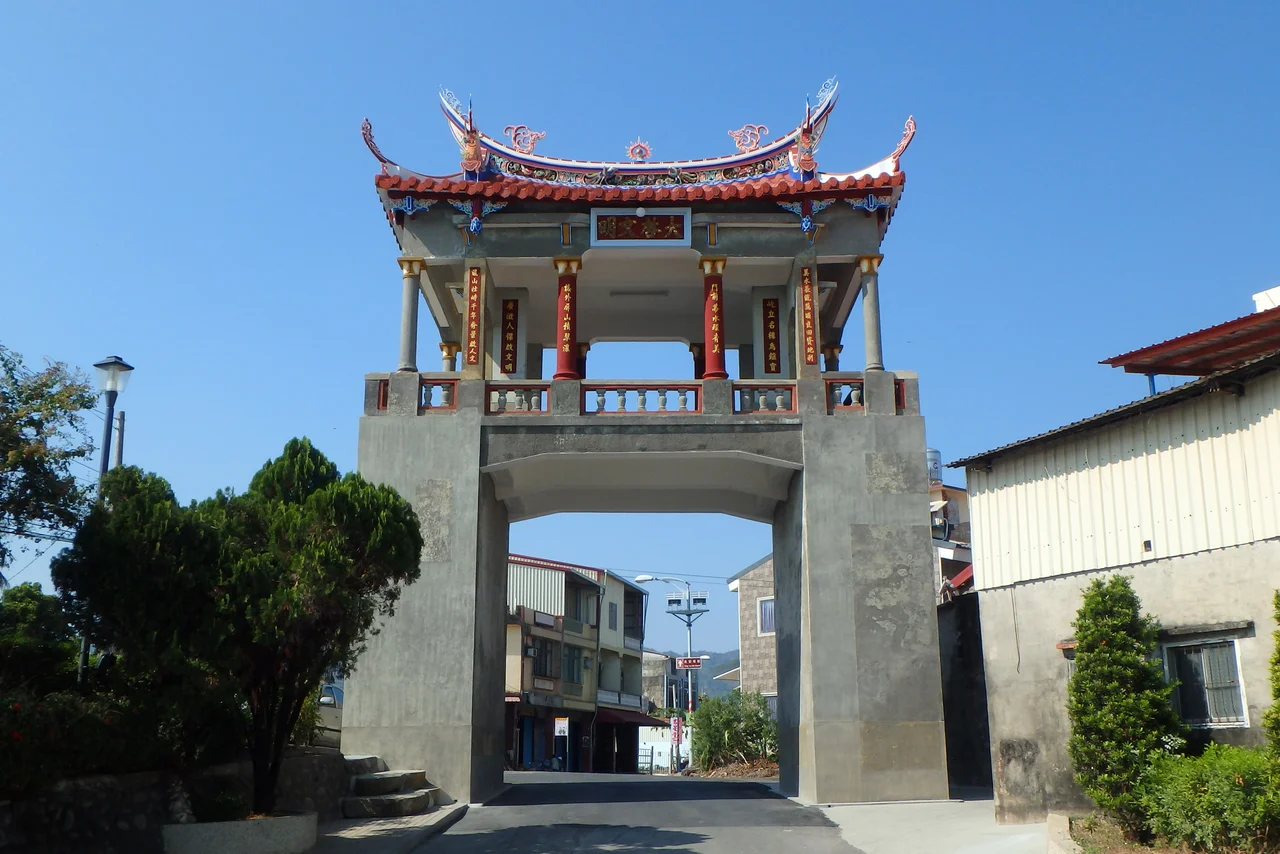

Meinong East Gate Tower
The banner above the gate reads *Khai-hak Bûn-bîng* — "Initiation of Civilization" — and it has watched over Meinong's main eastern approach for more than 270 years. Built in 1755 as a defense installation on the eastern edge of Minong Village, the Meinong East Gate Tower has outlasted Qing magistrates, Japanese colonizers, Pacific War air raids, and the postwar scramble to rebuild. It still stands at 10.63 meters tall, its brick and plaster unchanged in proportion from the dynasty that raised it, offering anyone who passes through a quiet lesson in how much can survive if people decide it's worth keeping.
Built to Hold a Frontier
In the mid-eighteenth century, Meinong was Hakka farmland carved out of Taiwan's southern interior. The Qing administration built the East Gate Tower to mark the settlement's eastern threshold and provide a point of defense against raids — a physical statement that this community had put down roots and intended to stay. Qing Dynasty architecture governed its form: a solid masonry gatehouse with a commanding roofline, proportioned for authority rather than elegance. For over a century it served that purpose, a fixed point in a landscape that was otherwise always shifting — forests cleared, paddies extended, families arriving from Guangdong by way of the Taiwan Strait.
The Year the Tower Fell
In 1895, Taiwan's transfer from Qing to Japanese imperial rule was not merely administrative. Communities across the island resisted, and Meinong was no exception. The East Gate Tower was destroyed during the revolt that year — whether by defenders using it as a fortification, by Japanese forces eliminating it as a stronghold, or simply in the confusion of the transition, the records don't specify. What is clear is that the tower's first life ended abruptly, and Meinong carried on without its defining eastern landmark for four decades. The gate's absence must have felt like a wound in the town's memory, because when the opportunity came to rebuild, the community seized it.
Rebuilt, Then Repurposed for Survival
In 1937, local merchants and dignitaries organized the tower's reconstruction — a civic act that reached back across four decades of absence to reclaim a piece of Hakka identity. The rebuilt gate followed the original Qing proportions, restoring the banner and the gatehouse form. Then came the Pacific War. During the 1940s, a small extension was added to the tower's top, and a large bell was hung there to serve as an air-raid alarm — the ancient gate pressed into service as an early-warning system for bombers. When the war ended, both the extension and the bell were removed, and the tower returned to something close to its 1937 form. The scars of that improvisation have faded. The survival has not.
A Monument the Town Decided to Keep
In May 2000, the Kaohsiung County Government designated the East Gate Tower as a county-level historical monument — formal recognition of what Meinong residents had long understood. The inscription above the gate, a simulation of a local elite's calligraphy, had always been read as a witness to Meinong's changes over time. Now it had legal protection to go with that symbolic weight. Today the tower stands in the middle of the town's daily life, close to the old streets and markets that define Meinong's character. Visitors can walk through the gate exactly as residents always have, the 10.63-meter structure framing a passage between present and past.
Meinong in the Round
The East Gate Tower is inseparable from the broader story of Meinong District — one of Taiwan's most distinctively Hakka communities, known for oil-paper umbrellas, tobacco cultivation, and a tenacious cultural identity that resisted assimilation through both Japanese colonial rule and the postwar Mandarin-dominant era. The gate is not a relic standing apart from that identity; it is one of its anchors. Standing beneath its roofline, with the sound of Hakka spoken on the street around you, the connection between architecture and community becomes immediate. The tower has outlasted every regime that passed through Meinong. The town is still here.
From the Air
The Meinong East Gate Tower sits at approximately 22.8956°N, 120.549°E, in the center of Meinong town in Kaohsiung's inland foothills. Approaching from the air at 3,000–5,000 feet, the broad Meinong Plain opens below with the Central Mountain Range rising sharply to the east — the same topography that made Meinong a defensible Hakka frontier settlement in the 1700s. The nearest major airport is RCKH (Kaohsiung International Airport), about 30 km to the southwest. Meinong's town grid is clearly visible from the air, with the gate tower located near the older central district. Clear days offer views to the Pacific coast to the west.
Nearby Stories
- Sanhe Tile Kiln 2.2 km away
- Yakou Mountain Pass 7.2 km away
- Taimali 9.2 km away
- 2025 Tainan–Chiayi Earthquake 17 km away
- Kunci Temple 19 km away
- Dongji Island 22 km away
- South Penghu Marine National Park 41 km away
- Daya Bay 548 km away