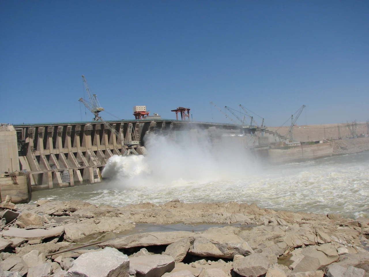
Merowe Dam
Compensation for a date palm amounts to about four years' harvest. A well-tended date palm can bear fruit for a hundred years. That math -- the kind you run while watching your grandfather's orchard get bulldozed -- tells much of what there is to tell about the Merowe Dam. Ten 125-megawatt Francis turbines now spin on the Nile at the Fourth Cataract, producing 5.5 terawatt-hours per year, nearly doubling Sudan's grid-connected electrical capacity when they came online in 2009. Between 55,000 and 70,000 people lost their villages, their riverbank date groves, and the only economy they had ever known. The dam is the largest hydropower project built in Africa in a century. It was also one of the most contested.
The Longest-Delayed Dam on the Nile
Colonial-era engineers had proposed a dam at the Fourth Cataract since the early twentieth century. The Anglo-Egyptian Sudan authorities returned to the idea repeatedly: equalize the Nile flow, irrigate cotton, tame the flooding. Sudan gained independence in 1956, and Egypt responded by building the Aswan High Dam to control the river from its own territory. President Nimeiri's military government revived the Sudanese plan in 1979. Four feasibility studies were commissioned through the 1980s. None of them produced construction. The money was not there. That changed in 1999 and 2000, when Sudan began exporting oil in commercial quantities. Suddenly Chinese, Arab Gulf, and European lenders all saw a creditworthy borrower. Contracts were signed in 2002 and 2003. Ground broke in early 2004, and on 3 March 2009 the reservoir was full, the generators were online, and Sudan had a dam nine kilometers long, 67 meters high, and containing about 15 percent of the Nile's annual flow.
What Got Flooded
The Manasir, Hamadab, and Amri peoples had farmed the Nile's islands and banks at the Fourth Cataract for centuries. Their villages had no paved roads, no grid power, and little contact with the rest of Sudan, but they were not poor in the ways that term usually means. Date palms on the fertile silt along the river were the region's most valuable possession, generating enough income to support self-sufficient communities. Families grew beans, millet, vegetables. Weekly markets moved goods between villages. Palm groves passed between generations like family businesses, each tree a compounding asset. Then Hamadab was resettled to Al-Multaga in 2003. The Amri went to Wadi Muqaddam in 2007. The Manasir were moved to Al-Mokabrab and Al-Fidah in 2008. Some refused. Many tried to stay near their old lands on the new lake's shore, becoming fishermen in a region that had never fished, earning less than they had before.
The Compensated Palms
Before the flooding, the government burned the compensated date palms so they could not be repossessed. Photographs from 2008 show smoke rising from the groves along the Nile. The UN rights expert Miloon Kothari reported that many displaced families had received no warning before water levels rose. Some remained temporarily homeless years later. Only married men were eligible for compensation for their houses. Vegetable gardens were valued almost nothing. A follow-up survey in early 2005 at Al-Multaqah found that poverty had increased dramatically because the new land could not produce anything marketable. Archaeologists working the salvage excavations ahead of the flood found themselves in a bind -- they were digging up 5,000 years of Nubian history, including a gold-mining center dating to the pharaohs, while the living Nubian communities of the same valley begged them to stop the dam that made their work possible. Most of the displaced families eventually took what compensation they could and rebuilt. None got back what was taken.
Who Paid, Who Built
The $2.945 billion project was funded by a coalition visible nowhere else in African infrastructure: China Import Export Bank led with $608 million. Arab Fund for Economic and Social Development contributed $477 million. Saudi Fund, Abu Dhabi Fund, Kuwait Fund, Oman Fund, and Qatar all joined, with the Sudanese government covering the remaining $1.114 billion. Chinese state-owned firms handled the main dam construction, Germany's Lahmeyer International managed the engineering, France's Alstom supplied the turbines. At the time it was signed, it was the largest international project Chinese industry had ever joined. The power lines now stretch 500 kilometers across the Bayudah Desert to Atbara and onward to Khartoum, Port Sudan, Dongola. Electrification in Sudan had been desperately low -- the average Sudanese in 2002 consumed roughly one fifteenth of their Egyptian neighbor's electricity. The dam cut that gap substantially, when it works.
War Comes to the Turbines
Since April 2023 Sudan has been consumed by civil war between the Sudanese Armed Forces and the Rapid Support Forces. On 13 January 2025, RSF drones struck the Merowe Dam's power station, setting fire to the facility and damaging a key transformer. The attack caused blackouts as far away as Shendi, Port Sudan, Atbara, and Omdurman. Further drone attacks in late 2024 and 2025 targeted the dam repeatedly and the nearby Merowe Airport. The dam's Nubian Liberation Front, a movement that had threatened armed resistance to the series of dams planned along the Nile, had already been warning for years that forced displacement would eventually produce armed response. The Kajbar dam project further north was formally cancelled in 2021 after the 2007 Kajbar massacre -- security forces firing on protestors. The Merowe Dam produces electricity for a country that can barely deliver it. The villages and palm groves under the reservoir do not reappear when the generators stop spinning.
From the Air
The Merowe Dam is located at approximately 18.67 degrees north, 32.05 degrees east on the Nile near the Fourth Cataract in Sudan's Northern State, about 350 km north of Khartoum. Best viewed at 15,000 to 25,000 feet, where the 174-km reservoir and the nine-kilometer dam structure become dramatic landscape features. Nearest airport: Merowe Airport (HSMN) immediately adjacent. Jebel Barkal and the ancient city of Napata are visible to the southwest. Note: the region has been active in the Sudanese civil war since 2023, with recurring drone attacks on the dam. Airspace and security conditions should be confirmed before any flight planning.
Nearby Stories
- Nubia 21 km away
- Monastery in Ghazali 25 km away
- Banganarti 96 km away
- R12 (cemetery) 118 km away
- Dongola Reach 178 km away
- Pyramids of Meroë 202 km away
- Nubian pyramids 228 km away
- Red Sea State 310 km away