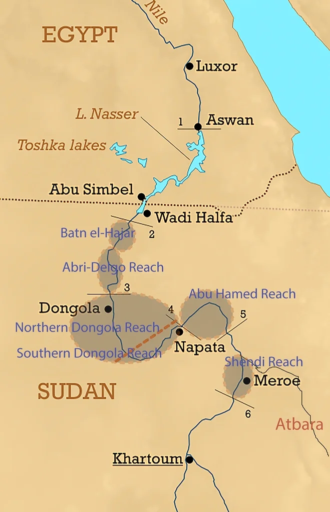
Dongola Reach
Fifty thousand years ago, someone built a hut near the Nile here. The remains of that structure, excavated at a site called Affad 23 in the southern part of the Dongola Reach, are among the oldest open-air shelters ever found anywhere in the world. Pushing that date backward, it means that for roughly a thousand centuries the 160 kilometers of river between the Third and Fourth Cataracts of the Nile has been a place people chose to live. The name on modern maps honors the Sudanese town of Dongola that dominates this section of the river. What it describes is older than any town and older than any name: a corridor of water, sandstone, and alluvial floodplain that was the heart of ancient Nubia.
Southern Reach, Northern Reach
Geographers divide the Dongola Reach into two parts because the river itself performs a strange maneuver here. At the Fourth Cataract the Nile meets the Central African Shear Zone, a tectonic boundary running diagonally across the continent, and turns sharply southwest. For roughly 280 kilometers the river flows in the wrong direction before rejoining its northward course. This bent stretch is the Southern Dongola Reach. Where the river recovers and heads north to the Third Cataract is the Northern Dongola Reach. The bend cradles dry valleys where ancient rivers once met the Nile: the extinct systems of Wadi Abu Dom, Wadi Muqaddam, Wadi Howar, and Wadi Al-Malik all join the Nile in the Southern Reach, connecting the Nile Valley across the desert to the Red Sea in the east and to inner Africa in the west. The Dongola Reach is a crossroads, disguised as a riverbank.
The Geology Under the Civilization
The Nile here flows over mostly sandstone bedrock, flanked by wide alluvial floodplains. In the Northern Reach, large cultivable basins on the eastern side of the valley, including the Kerma Basin, are fed by a network of palaeochannels: old river courses whose ghosts still carry water during the flood season. These basins grew some of the first agricultural surpluses in Africa outside Egypt. The soils were rich enough, and reliable enough, to support the population densities that enabled complex state formation. The Nile here does not have significant perennial tributary inputs. The river is essentially the only water source, which meant the places where it ran wide and flat became the places where civilizations grew.
Kerma, Kush, Makuria
Three great civilizations emerged from this stretch of river. The Kerma culture flourished between roughly 2500 and 1500 BCE, with its capital at Kerma on the eastern bank of the Northern Dongola Reach, and it was the first major kingdom south of Egypt. Kerma traded with Egypt as an equal and at times fought Egypt as a rival. After Kerma's fall, the Kingdom of Kush emerged further south with capitals first at Napata and then at Meroe, but its northern territory and agricultural base lay largely in the Dongola Reach. Kush was so powerful by the eighth century BCE that its kings conquered Egypt and ruled as the Twenty-fifth Dynasty. In the medieval period, after the Christianization of Nubia in the sixth century CE, the kingdom of Makuria made Old Dongola its capital. For nearly a thousand years Makuria was a Christian state that held its own against the expanding Islamic caliphates to the north.
What the Soil Preserves
The Dongola Reach is archaeologically dense. Abundant sites line the banks of old Nile channels in the Northern Reach, representing every period from the Paleolithic through the Islamic. Derek Welsby's 2001 book Life on the Desert Edge: Seven Thousand Years of Settlement in the Northern Dongola Reach summarizes decades of excavation documenting continuous human occupation across a landscape that looks, at first glance, too arid to have mattered. Polish archaeologists, particularly the team directed by Bogdan Zurawski through the Southern Dongola Reach Survey since 1998, have focused on the medieval Christian period, documenting sites like Banganarti and Selib where churches and fortifications from Makuria still stand. The Sudanese National Corporation for Antiquities and Museums partners with international teams on most of this work. The ongoing Sudanese civil war since 2023 has made new excavation difficult, but the sites themselves endure.
A Line Drawn by the River
From the air the Dongola Reach is easy to recognize. The great S-bend is visible at any reasonable altitude, a distinctive backwards curve where the Nile seems to change its mind. The dark alluvial fields run directly against the tan of the surrounding desert in sharp relief. The modern town of Dongola lies on the western bank near the middle of the Northern Reach, a small city that anchors a region with disproportionate historical weight. Upstream on the opposite bank sits Old Dongola, the abandoned medieval capital of Makuria, where excavators have uncovered churches, palaces, and the remains of what was once one of the most important cities south of Aswan. For more than fifty thousand years, people have chosen to live along this particular stretch of river. The archaeology cannot fully explain why, but the geography suggests an answer: this is where the Nile is broadest, the floodplain widest, and the soil richest for a thousand kilometers in any direction.
From the Air
The Dongola Reach runs from approximately 19.8 N, 30.2 E (Third Cataract) to 18.7 N, 32.4 E (Fourth Cataract) in Sudan. Central coordinate 19.25 N, 30.50 E. Nearest airports: Dongola Airport (ICAO HSDN) and Merowe Airport (ICAO HSMR). Active Sudanese civil war makes civilian overflight hazardous. From cruise altitude the distinctive S-bend of the Nile is an unmistakable navigation feature in otherwise featureless desert terrain.
Nearby Stories
- Kerma 9.9 km away
- El Khandaq 46 km away
- Nubia 61 km away
- Napata 122 km away
- Northern State (Sudan) 159 km away
- Selima Oasis 215 km away
- Semna (Nubia) 221 km away
- Lake Ptolemy 408 km away