Semna (Nubia)
The Egyptians called the fort at Semna South "Subduer of the Setiu-Nubians." Archaeologists only learned that name in 1966, when pottery seal impressions came out of a buried dump. Before then, all they had was a fragmentary hieratic inscription on a scrap of papyrus found near the Ramesseum in 1896, reading "Repressing the..." and breaking off. Between 1965 and 1971, as Lake Nasser rose behind the new Aswan High Dam, the four mud-brick fortresses at Semna disappeared beneath the water. The name, recovered just in time, tells you what Middle Kingdom Egypt wanted Semna to be.
The Narrowest Gorge
Semna lies - lay - 15 miles south of Wadi Halfa, where granite ridges pinch the Nile into its narrowest run, the Semna Cataract. At this strategic choke point, Egypt's 12th Dynasty pharaohs built a cluster of four mud-brick forts in the reign of Senusret I (1965-1920 BCE): Semna, Kumma, Semna South, and Uronarti. They were the southernmost anchor of a chain of seventeen Middle Kingdom Egyptian forts designed to control the Nubian frontier. The forts' walls were reinforced with wooden logs - a clever detail that made them stronger but also vulnerable, since the logs burned when attackers set fires. Traces of those fires are still visible on the walls in photographs from the 1920s excavations. The forts had doubly fortified gates and fortified corridors running down to the Nile so that defenders could reach water under cover even during a siege.
Who Controlled the Gold
Semna existed to control trade. Egyptian viceroy George Reisner, excavating in 1924 and 1928, cataloged what the forts were there to regulate: the goods moving north from inner Africa into Egypt. Reisner in 1929, quoting Middle Kingdom sources, listed the "southern products" these forts watched: ebony, ivory, pelts, incense and resin, ostrich feathers - and enslaved people, described with the dehumanizing shorthand of the ancient texts. The Nubians who were captured and sold north were real people whose lives were interrupted and ended by this trade, not commodities on a ledger, and the forts at Semna were part of the machinery that moved them. The Egyptian name of the Semna South fort - "Subduer of the Seti-land" - announces the relationship plainly. These were instruments of empire, not friendly border stations.
C-Group Neighbors
And yet the picture gets complicated. When Louis Vico Zabkar's team from the University of Chicago's Oriental Institute excavated Semna South between 1966 and 1968, they found pottery sherds of the C-Group type in the fort's dump. The C-Group were indigenous Nubian people living in the region from around 2000 to 1500 BCE. Their pottery inside an Egyptian fort's refuse suggests day-to-day coexistence - maybe even peaceful trade - alongside the overtly coercive mission the forts were built for. Contrary to Jean Vercoutter's earlier conclusion that the fort was only seasonally occupied, Zabkar's deeper excavation found evidence of permanent occupation from Senusret I through the early reign of Amenemhat III. There was also a great wall connecting Semna South to Semna West - further evidence that the fortifications functioned as a linked defensive complex, probably built in response to what the famous Semna Dispatches describe as pressure from southern raiders.
A 2,000-Year Cemetery
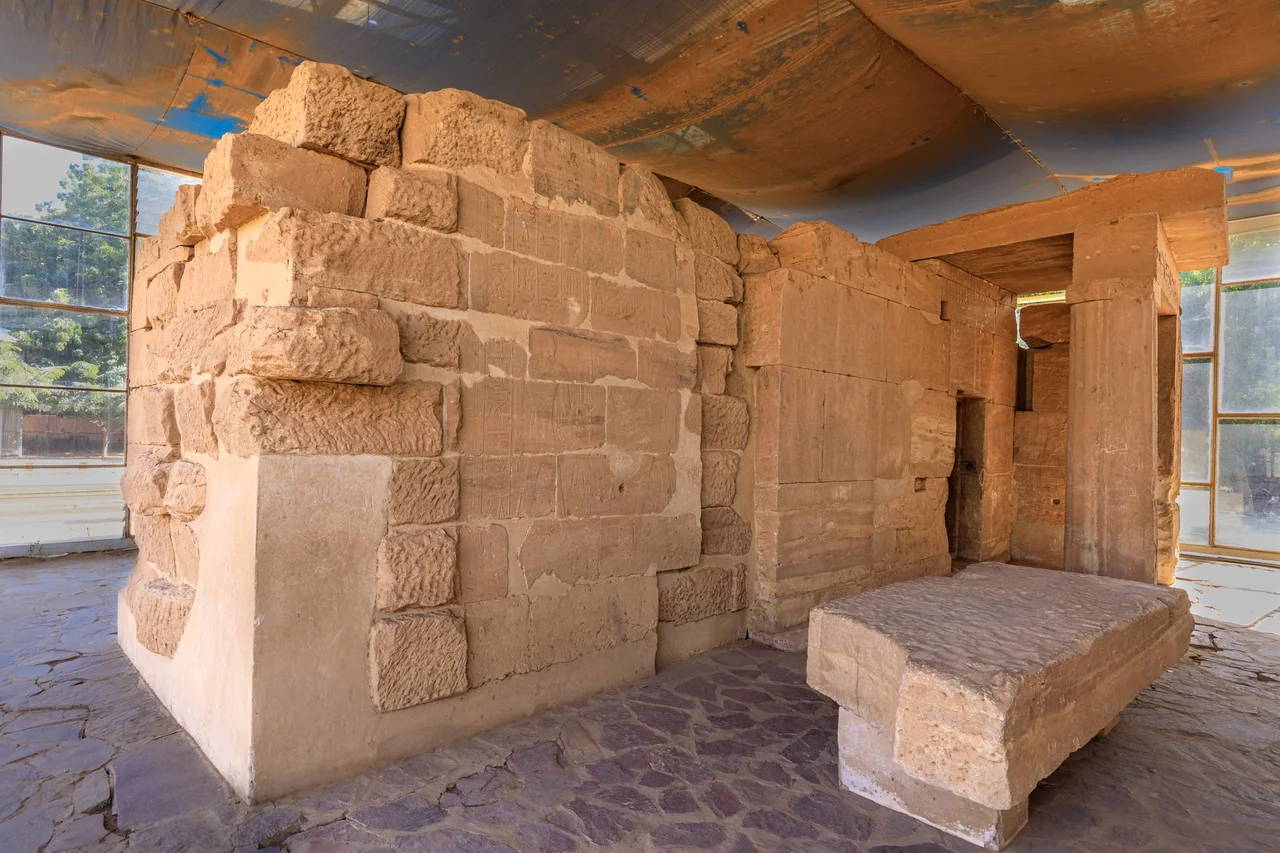
The most moving part of Semna is not its forts but its cemetery. North of the fort lay approximately 560 graves, holding over 800 individuals - 494 from the Meroitic period, 50 from the X-Group, and 16 from the Christian era. Two thousand years of Nubians buried themselves next to this same rocky outcrop. The Meroitic dead lay extended on their backs with heads to the west, often accompanied by bronze mirrors, jewelry, copper bowls, and fragments of linen shroud. The X-Group dead lay flexed on their sides. The Christians, centuries later, lay straight again in oblong shafts, wrapped in wool and linen, heads to the west. Anthropologist Alvrus, studying the skeletal remains from almost 600 individuals, found that 21% of adults had at least one healed fracture - and the skull was the most frequently injured region. Some of that was the rocky terrain. Some of it was interpersonal violence. Life on this stretch of frontier was not easy in any era. Today, human remains from Semna South are curated at Arizona State University, and the archaeological artifacts are at the University of Chicago. The temples of Dedwen and Sesostris III were moved to the National Museum of Sudan in Khartoum before the flood. Everything else is under the lake.
From the Air
Historical location at approximately 21.50N, 30.97E - now submerged beneath Lake Nasser on the Egypt-Sudan border, about 15 miles south of Wadi Halfa. Recommended viewing altitude: 4,000-6,000 feet AGL to see the distinctive narrow section of the reservoir where the ancient Semna Cataract once forced the Nile into a gorge. The forts themselves are underwater. Nearest airports are Wadi Halfa (HSSW area) to the north and regional airstrips much further south. The granite ridges that created the Batn-El-Hajar - the "Belly of the Rock" region - are still visible on the shores of the lake, a harsh and spectacular landscape.
Nearby Stories
- Mirgissa 5.9 km away
- Meinarti 29 km away
- Kulb 52 km away
- Battle of Ginnis 80 km away
- Lake Nasser 81 km away
- Qasr Ibrim 129 km away
- Dar al-Manasir 267 km away
- Kharga Oasis 384 km away