Mirgissa
The French archaeologist Jean Vercoutter found the grave in the desert west of the fortress. Inside were roughly 3,500 pottery fragments. When researchers began piecing them together, they realized they were not broken pots but Execration Texts -- ritual curses painted on vessels, inscribed with the names of Egypt's enemies in foreign lands and their rulers, and then smashed to release the magic. The fragments had been carefully buried together in a single grave, the curses sealed where they could do their work. Mirgissa's small temple to Hathor, the Egyptian goddess who protected pharaohs and mothers, stood inside walls twelve meters thick. The Middle Kingdom pharaohs meant this place to hold Egypt's southern frontier. They built it big enough that it is still the largest Egyptian fortress ever found in Nubia.
A Customs Post With Teeth
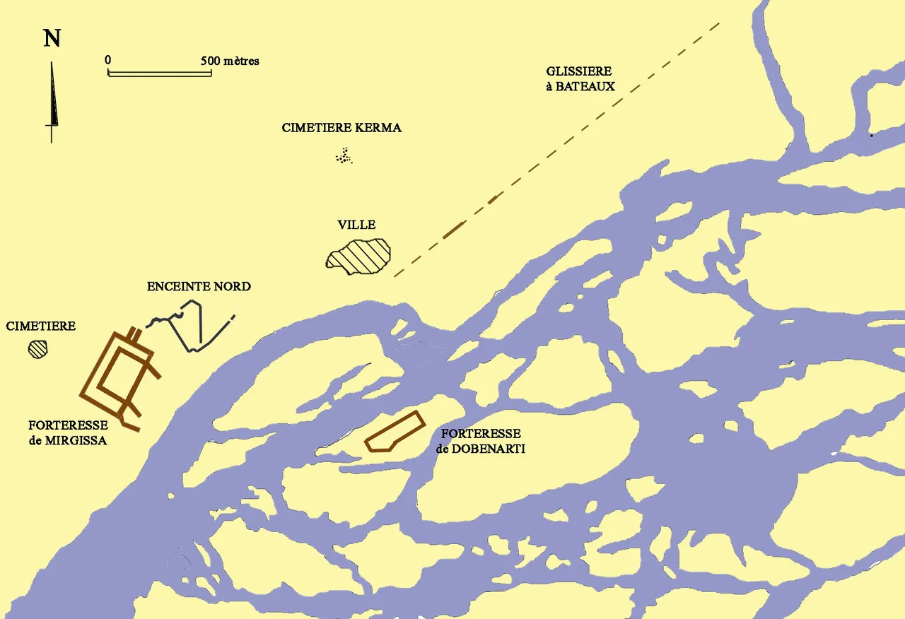
Mirgissa, known to its ancient inhabitants as Iken, sat on a rise above the Nile at the Second Cataract in what is now northern Sudan. Travelers coming downriver from Kush had to stop here. The rapids of the cataract made the Nile impassable by boat; cargo and crew transferred to land, and Mirgissa's sentries from their elevated position could watch troop movements for miles. During the Twelfth Dynasty, beginning around 1900 BCE, it served as a customs post for traffic heading north into Egypt. The fortress was one of eleven built by Senusret III between the Second and Third Cataracts to defend a border that Egypt drew and redrew across Nubia. Shalfak, Uronarti, Askut, Semna, Kumma, Sumna South -- the names form a chain of forts. Mirgissa was the largest, covering more than 40,000 square meters, controlling the economic exchanges between the Kingdom of Kush and Egypt at a bottleneck where the river itself made commerce impossible without cooperation.
Walls Thick Enough to Stop Time
The great fortress's double wall rose twelve meters high and spread more than six meters thick at the base. Bastions and square-cornered towers anchored the corners. A ditch protected both entrances. The south wall, facing the Nile, ran along a rocky ridge that gave the structure a natural foundation. Two enormous gates opened in the perimeter -- one to the north with a narrow passage blocked by two massive wooden doors and a portcullis, the other near the southeastern corner. The brickwork climbed the slope using angled bedding planes, a subtle engineering trick that kept horizontal courses aesthetically straight while actually following the hill. During Thutmose II's reign around 1492 to 1479 BCE, roughly 250 to 450 people inhabited the area. Most intense occupation came during the Thirteenth Dynasty and the Hyksos era, as proven by the vast quantity of scarab beetles found on site -- tiny clay insects used as seals and amulets, more abundant here than at almost any Nubian counterpart.
The Two-Kilometer Boat Slide
Vercoutter's 1962-1969 expedition made one discovery that still reads like historical fiction: a boat slipway more than two kilometers long, extending from Mirgissa to the natural harbor at the southern end of the cataract. Evenly spaced wooden cross beams were embedded in silt, the mud layers wetted and re-wetted to stay slippery. Egyptian traders could drag their boats bodily overland across these beams, bypassing the impassable rapids, reducing hull friction on clay kept lubricated by river mud. It is one of the oldest overland boat-transfer systems documented anywhere. Nearby stood the smaller fortress of Dabenarti on a 2.5-hectare rocky islet, now only foundations. Dabenarti protected the southern harbor where boats from Upper Nubia could dock in calm waters. Together the two forts controlled everything that moved between the Mediterranean world and the gold, ivory, and enslaved peoples of Kush -- and levied the customs that made Egypt's southern border into a revenue stream.
The Curse Pit
The Execration Texts found in that desert grave are one of the strangest archives of ancient diplomacy. Egyptian scribes would write on a pot the name of a foreign land -- Kush, Libya, Retjenu -- along with the names of its rulers and leaders. The pot would be consecrated, smashed, and the fragments buried ritually. The magic, Egyptians believed, would work on the named enemies wherever they were. Mirgissa's pit contained pottery naming foreign countries that Egypt considered hostile during the late Middle Kingdom. The ritual embedded foreign policy directly into the archaeological record. Near the pit, Vercoutter's team found three statues from the Twelfth Dynasty and a seal belonging to Nebiryraw I of the Sixteenth Dynasty. The fortress was sporadically re-occupied during the Meroitic era before being finally abandoned during the early Christian period, though its strategic position ensured that people kept coming back to it across almost two thousand years.
Water and Permission
Sir Henry George Lyons, an English geologist, reached the fortress in 1892, the first European to document the site. Vercoutter's French expedition came seventy years later -- and, notably, excavated without Sudanese government permission. That detail sits awkwardly in the record. The French expedition was part of the UNESCO-coordinated salvage archaeology program that raced to document the Nubian Nile valley before the Aswan High Dam's reservoir drowned it. Hundreds of sites were rescued in part. Many were not. Mirgissa was excavated to unprecedented detail between 1962 and 1969, then handed over to the rising water of Lake Nubia. The fortress that had controlled Egypt's southern border for centuries now sits submerged beside the ancient boat slipway, the Hathor temple, the cemeteries, and the stele that gave Iken its name. The curses are still buried. No one has come to read them.
From the Air
Mirgissa's location is at approximately 21.82 degrees north, 31.17 degrees east on what was the west bank of the Nile at the Second Cataract, now submerged in Lake Nubia. Best viewed at 15,000 to 20,000 feet to appreciate the broad reservoir of Lake Nubia / Lake Nasser extending from Wadi Halfa north to the Egyptian border. Nearest airports: Wadi Halfa (HSSW) to the south, Aswan International (HEBA) far to the north in Egypt. Extreme desert conditions, intense heat, and occasional dust storms; the submerged site itself cannot be seen from the air.
Nearby Stories
- Nabta Playa 16 km away
- Uronarti 17 km away
- Lake Nasser 45 km away
- Meinarti 68 km away
- Qasr Ibrim 93 km away
- Battle of Ginnis 119 km away
- Dar al-Manasir 304 km away
- Kharga Oasis 345 km away