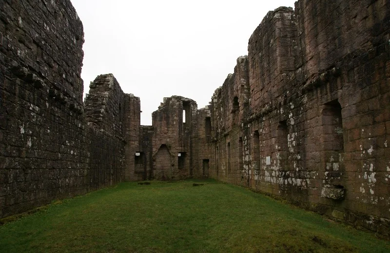

Morton Castle
Find Morton Castle and the fun begins. Wikivoyage advises leaving the A76 at Carronbridge, taking the A702, and turning at the second right. The reward for the small detour is a 14th-century ruin standing on a high promontory above an artificial loch in the hills two and a half miles northeast of Thornhill, often with no one else in sight. The walls reflect in the still water on three sides. The view stretches across Nithsdale. The castle once formed part of a chain of fortifications along the strategic Nith Valley, which runs from the Solway Firth north to the Clyde Valley, but today most travellers drive straight past without ever knowing it exists.
Dunegal's Honour
In the 12th century the honour of Morton belonged to Dunegal, Lord of Strathnith, the local ruler of Nithsdale. A ditch to the south of the present castle is thought to date from this earliest period, though it may simply be a natural feature. During the reign of Robert the Bruce, the lands passed to Thomas Randolph, later first Earl of Moray and Bruce's right hand. By 1307, and possibly as early as the 1260s, a castle stood on the high defensible promontory surrounded by marshland. Randolph also constructed an enclosed deer park nearby, befitting a nobleman of his stature. The location was chosen for the same reason every medieval castle was: a hill, water on the flanks, sightlines that gave the lord time to react to anyone approaching.
Treaty of Berwick
In 1357 came the Treaty of Berwick, the agreement that finally secured the release of King David II from his eleven-year captivity in England. The terms required the Scots to destroy thirteen castles in Nithsdale, Morton among them. It was the kind of demand that reshaped landscapes: deliberate, calculated demolition of the local infrastructure of independence. How much of the original castle came down is unclear, and how much of what stands today is original is genuinely unknown. The lands then passed to the earls of March, who probably built or rebuilt the present castle in the early 15th century. Architectural debate continues over whether the defensive elements survive from the 14th-century original or are part of the later rebuild.
Two Architectural Voices
Morton Castle bears a curious resemblance to Caerlaverock Castle further south, triangular in plan with twin gatehouses at the southwest corner. One of two D-plan towers still stands to four storeys, with a pit prison beneath. Above the prison, an elaborate fireplace in one room suggests this was the lord's lodging. Only the foundation of the second gate tower remains. The original gate had a portcullis and a turning bridge over a pit. Yet contrasting with this defensive seriousness, the long range of buildings across the south features large arched windows and a lack of arrow loops. This range was built or remodelled as a hunting lodge. Two voices speak from the same stone: the warrior architect at the gate, the country gentleman in the great hall.
Murder, Mistress, Forfeiture
In the mid 15th century James II of Scotland gave the lands to James Douglas of Dalkeith, later Earl of Morton, though the earldom takes its name from another Morton in Lothian. The fourth Earl of Morton, regent of Scotland, was executed in 1581 for his alleged part in the 1567 murder of Lord Darnley, husband to Mary, Queen of Scots. The castle and earldom briefly passed to John Maxwell, 7th Lord Maxwell. In 1588 James VI led an expedition against the Catholic Maxwells, and Morton Castle was taken and burned. The earldom returned to the Douglas line after the fourth earl's attainder was reversed. In 1608 the castle was sold to William Douglas of Coshogle, and ten years later to William Douglas of Drumlanrig, the future first Earl of Queensberry.
The Loch That Was a Marsh
The castle was at least partially occupied until 1714, probably as a hunting lodge rather than a permanent dwelling. In the 18th century the marsh below the promontory was deliberately dammed, and the artificial loch was born. The new water transformed the setting: a quiet brown wetland became a mirror reflecting the broken silhouette of the old fortress. After the castle was finally abandoned, stone was steadily carried off, the way medieval stone was nearly always recycled, until the 1890s when some repairs slowed the loss. Morton is now property of the Duke of Buccleuch and cared for by Historic Environment Scotland. It is a Scheduled Ancient Monument, freely open to anyone who finds it. Few do. The arrival is its own reward, the silence at the loch its own answer.
From the Air
Morton Castle sits at 55.27 degrees north, 3.75 degrees west, in the hills above Nithsdale 2.5 miles northeast of Thornhill in Dumfries and Galloway. The ruined castle is reflected in an artificial loch on three sides, easily visible from the air as a small bright water against the heather. Cruise at 2,500 to 3,500 feet to take in the castle, its surrounding loch and parkland, and the Nith Valley sweeping south. Dumfries Aerodrome (EGCO) lies about 22 miles south. Glasgow Prestwick (EGPK) is roughly 35 miles northwest, and Carlisle Lake District Airport (EGNC) sits 48 miles southeast. The A702 climbs east from the A76 at Carronbridge.
Nearby Stories
- National Museum of Costume 5.8 km away
- Quintinshill Rail Disaster 6.3 km away
- Darvel 8 km away
- Traquair House 9.3 km away
- Douglas Castle 9.4 km away
- Battle of Arkinholm 18 km away
- Cumnock 19 km away
- Kirkinner 26 km away