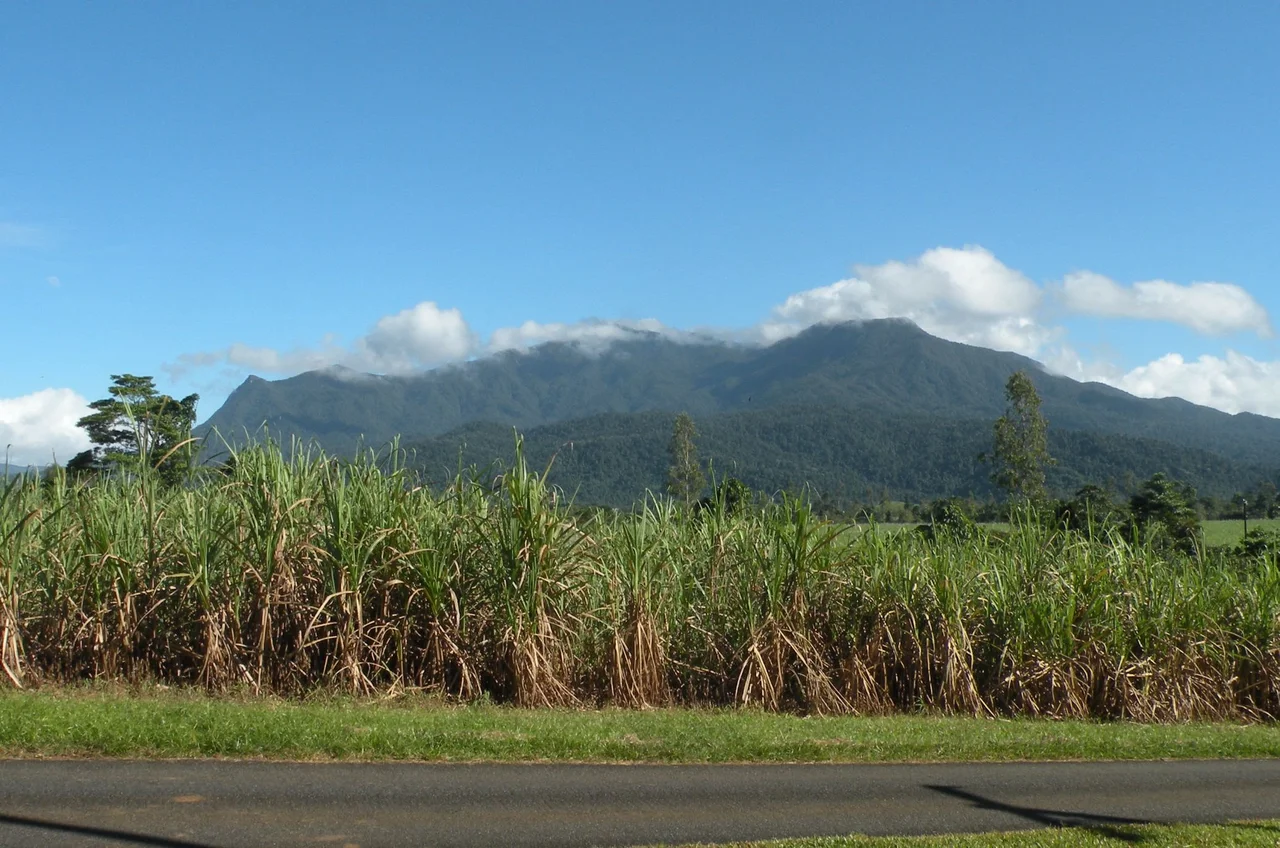

Mount Bartle Frere
Long before any surveyor pinned a foreign name to it, this summit had a name and a purpose. The Ngadjon-Jii people called it Choorechillum, and they understood it as a place where the spirits of the dead return - the highest ground in a country they had walked for thousands of years. Rising around 1,622 metres out of the Wet Tropics rainforest southwest of Cairns — a 2016 Geoscience Australia resurvey puts the official figure closer to 1,611 metres — the mountain Europeans labelled Mount Bartle Frere is still the tallest point in Queensland, and one of the wettest places on the continent. Its slopes are wrapped in green from foothill to peak, and its crown spends much of the year hidden inside its own weather.
A Forest That Never Stops Climbing
Most great mountains break free of the trees somewhere near the top. Choorechillum barely does. Rainforest cloaks it the whole way up, shifting in character as the air cools and thins. Down low, the lowland tropical forest is a riot of broad-leaved trees, palms, ferns, and vines tangled into a single living wall. Climb higher and the leaves shrink, the canopy lowers, and the forest grows quieter and stranger. Above 1,000 metres, mist rolls in almost daily, and the trees enter the realm of cloud forest - gnarled, stunted, and so thickly upholstered in moss and other plants that the bark all but disappears. Near the summit, one tree, Eucryphia wilkiei, grows nowhere else on Earth, its closest cousins clinging to the cool rainforests of Tasmania and Chile, half a world and an ice age away.
Rain Beyond Measure
No rain gauge sits on the summit, but the numbers from nearby Mount Bellenden Ker tell the story. Estimated annual rainfall on these peaks runs to around 8,000 millimetres, with a potential maximum that could reach an astonishing 17,000 - among the heaviest on the planet. Even the so-called dry season here is wet by any normal standard. In 1911, calculations based on lowland data suggest a single day during a cyclone may have dumped as much as two metres of rain, which, if accurate, would rank among the greatest daily downpours ever recorded anywhere. This relentless water is the mountain's sculptor and its guardian, feeding the Russell River, leaching the granite soils, and keeping the cloud forest perpetually dripping.
The Climb and the Cloud
Christie Palmerston was the first European recorded to reach the top, in October 1886; he blazed a tree with his initial and the date and left it at that. Today the standard route climbs roughly 15 kilometres return from the Josephine Falls car park, gaining around 1,500 vertical metres through slick roots, leech-rich undergrowth, and yellow markers spaced every kilometre. Ten to twelve hours is normal. The summit's promised reward - a sweep over the coastal lowlands one way and the Atherton Tablelands the other - is anything but guaranteed, because the peak so often sits inside the very clouds that feed its forest. Experienced walkers start before dawn in the dry months, from April to October, and accept that the view may never arrive.
Creatures of the Summit
The high country shelters life found almost nowhere else. The Bartle Frere skink, an endangered lizard, lives on these upper slopes and the peaks around them, adapted to the cool, wet, alpine-feeling world near the top. Two other lizard species carry the mountain in their scientific names. Among the granite boulders of the cloud forest grows Rhododendron lochiae, Australia's only native rhododendron, sometimes rooted in rock, sometimes perched high in the canopy as an epiphyte. BirdLife International recognises the mountain as part of the Wooroonooran Important Bird Area, a refuge for birds that exist only in Queensland's Wet Tropics. It is a small, vertical island of cool-climate species marooned in the tropics.
A Mountain at War
The peak holds a quieter, sadder distinction too. On 21 April 1942, an American B-25 Mitchell bomber slammed into the mountain in cloud, killing all seven men aboard. The aircraft had only recently come home from the Royce Raid, a daring strike against Japanese forces in the Philippines, and then met its end not in combat but on a fog-bound Australian peak. Decades on, the wreckage still lies on the slopes, the white US star insignia visible in photographs from the 1980s - a reminder that even in this remote rainforest, the reach of the Second World War left its mark, and that seven young crewmen rest somewhere in Choorechillum's enduring green.
From the Air
Mount Bartle Frere sits at 17.38 degrees S, 145.82 degrees E, roughly 51 km south of Cairns and southwest of Babinda, on the eastern edge of the Atherton Tablelands. Its 1,622 m granite summit (re-surveyed in 2016 to about 1,611 m) is the highest terrain in Queensland and a serious obstacle - it is frequently capped in cloud, with rain among the heaviest on Earth. Cairns Airport (ICAO YBCS) lies about 60 km to the north-northwest; the smaller field at Mareeba (YMBA) is northwest across the Tablelands. Approach with generous terrain clearance and expect orographic cloud, turbulence, and rapidly changing visibility on and around the Bellenden Ker Range. Clearest views come in the dry season, April to October.
Nearby Stories
- Andrew Leon 12 km away
- HMS Mermaid (1817) 14 km away
- Mbabaram language 21 km away
- Paronella Park 26 km away
- Mount Mulligan Mine Disaster 41 km away
- The Great Barrier Reef: The Living Structure Visible from Space - Now Dying 92 km away
- Undara Volcanic National Park 94 km away
- Kapa Kapa Trail 818 km away