Mount Ruang
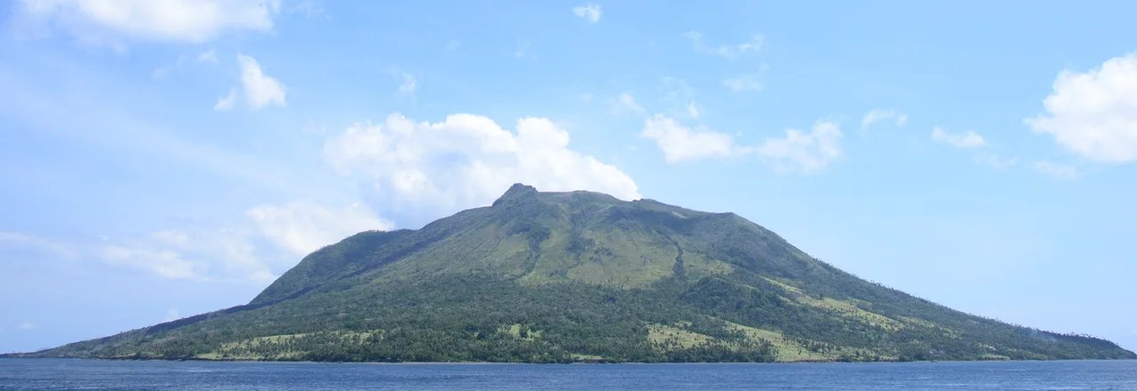
From the summit of Mount Ruang, you can see three worlds. To the south, the peak of Mount Klabat rises above the Sulawesi mainland. Northward, Siau Island marks the next link in the Sangihe volcanic chain. To the east, Ternate glimmers across the sea. Ruang itself is the southernmost stratovolcano in the Sangihe Islands arc, a 725-meter cone that constitutes an entire island in North Sulawesi. It has erupted at least 16 times since 1808, and its most recent outburst in April 2024 reminded everyone within a thousand kilometers that this small island volcano punches far above its weight.
Anatomy of an Island Volcano
Ruang is a volcanic island in the most literal sense: the mountain is the island and the island is the mountain. The summit is partially filled by a lava dome formed during eruptions in 1904, and subsequent activity has produced additional domes and pyroclastic flows that have reshaped the peak repeatedly. The geology is typical of subduction-zone stratovolcanoes, where the Pacific Plate dives beneath the Eurasian Plate along the Sangihe arc, generating the magma that feeds Ruang and its neighbors. What makes Ruang particularly dangerous is its location. An island volcano that collapses into the sea generates tsunamis, and Ruang's proximity to populated islands like Tagulandang makes every major eruption a multi-hazard event.
April 2024: The Sky Goes Dark
The eruption sequence began in mid-April 2024 and escalated rapidly. Authorities established a 4-kilometer exclusion zone around the crater, then extended it to 6 kilometers. On 17 April, Indonesia raised the alert to level four, its highest, and issued a tsunami warning based on the risk of the volcanic edifice collapsing into the sea. Orders went out to evacuate 11,000 residents and evacuees on Tagulandang to Manado on the Sulawesi mainland. Sam Ratulangi International Airport in Manado shut down. The Siau Tagulandang Biaro Islands Regency declared a 14-day state of emergency. At least 501 houses and buildings sustained damage from ashfall and volcanic debris.
A Plume That Crossed Borders
When Mount Ruang erupted again on 30 April, the consequences reached far beyond North Sulawesi. Airports as distant as Gorontalo Province were forced to close. All 843 residents of Ruang Island were evacuated to Manado, while 12,000 people on Tagulandang were relocated to Siau Island by ship. The sulfur dioxide plume extended over 1,000 kilometers, blanketing the entirety of Borneo by 19 April. Airlines from Malaysia and Singapore canceled flights to Sabah and Sarawak due to reduced visibility. Volcanic haze was detected briefly in Brunei's airspace. Surface air quality in Malaysian Borneo remained within acceptable limits, but the episode demonstrated how a modest-looking island volcano in a remote corner of Indonesia can disrupt aviation and atmospheric conditions across Southeast Asia.
Living Beside the Fire
The 843 residents of Ruang Island were not strangers to evacuation. The volcano's eruption history stretches back over two centuries, and life on the island has always been a negotiation with geological risk. Fishing communities have rebuilt after eruptions, resettled after evacuations, and returned to the slopes when the mountain quieted. The 2024 eruption may have changed that calculus permanently. With the entire island population relocated to Manado and the crater still active, the question of whether Ruang Island can sustain permanent habitation has become a matter of government policy rather than individual choice. The volcano, indifferent as volcanoes are, continues to steam.
From the Air
Located at 2.305N, 125.365E in the Sangihe Islands arc between Sulawesi and Mindanao. The volcanic island is clearly visible as a conical peak rising from the sea. CRITICAL: Active volcano with recent major eruptions in April 2024. Maintain safe altitude and distance; check NOTAMs for exclusion zones and ash advisories. Sam Ratulangi International Airport (ICAO: WAMM) in Manado is approximately 130 km south-southwest. Siau Island and Tagulandang are the nearest populated islands. Volcanic ash and SO2 plumes can reach FL400+ and extend over 1,000 km. Exercise extreme caution.
Nearby Stories
- Siau Island 12 km away
- Bangka Island (North Sulawesi) 41 km away
- Bunaken National Park 52 km away
- Bunaken 84 km away
- USS Shark (SS-174) 160 km away
- Mount Ibu 221 km away
- 1913 Sulawesi-Mindanao Earthquake 323 km away
- Basilan 534 km away